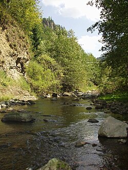
Bistrița (Someș)
| Bistrița Bistrița ardeleană Bistricioara Beszterce | |
|---|---|
 Bistrița at Colibița | |
 | |
| Location | |
| Country | Romania |
| Counties | Bistrița-Năsăud County |
| Towns | Bistrița |
| Physical characteristics | |
| Mouth | Șieu |
• location | Sărățel |
• coordinates | 47°3′31″N 24°25′45″E / 47.05861°N 24.42917°E |
| Length | 67 km (42 mi) |
| Basin size | 650 km2 (250 sq mi) |
| Discharge | |
| • location | Bistrița |
| • average | 7.22 m3/s (255 cu ft/s) |
| Discharge | |
| • location | Mouth |
| • average | 7.28 m3/s (257 cu ft/s) |
| Basin features | |
| Progression | Șieu→ Someșul Mare→ Someș→ Tisza→ Danube→ Black Sea |
| Tributaries | |
| • right | Bârgău |
The Bistrița (Romanian pronunciation: [ˈbistrit͡sa] ; Hungarian: Beszterce) is a river in the Romanian region of Transylvania, Bistrița-Năsăud County. It is sometimes referred to as Bistrița ardeleană.[1] Near the city of Bistrița (at the village Sărata) it flows into the Șieu,[2] a tributary of the Someșul Mare.[3][4] Its length is 67 km (42 mi) and its basin size is 650 km2 (250 sq mi).[4]
The upper reach of the river, upstream of the junction with the Bârgău in the village of Prundu Bârgăului is also known, locally, as Bistricioara.[5]
Towns and villages
[edit]The following towns and villages are situated along the river Bistrița, from source to mouth: Colibița, Bistrița Bârgăului, Prundu Bârgăului, Josenii Bârgăului, Livezile, Bistrița
Tributaries
[edit]The following rivers are tributaries to the river Bistrița:[4]
Left: Pănuleț, Repedea, Pârâul Stegii, Șoimu de Sus, Șoimu de Jos, Pietroasa, Poiana, Tănase, Fânațele, Ghinda
Right: Izvorul Lung, Bârgău, Valea Muntelui, Muncel, Iad, Slătinița, Valea Rus, Tărpiu
References
[edit]- ^ Cadrul geografic, Primăria Tiha Bârgăului
- ^ Bistrita ardeleana / Colibita (jud. Bistrita Nasaud), e-calauza.ro
- ^ "Planul național de management. Sinteza planurilor de management la nivel de bazine/spații hidrografice, anexa 7.1" (PDF, 5.1 MB). Administrația Națională Apele Române. 2010. pp. 71–73.
- ^ a b c Atlasul cadastrului apelor din România. Partea 1 (in Romanian). Bucharest: Ministerul Mediului. 1992. pp. 64–65. OCLC 895459847. River code: II.1.24.4
- ^ Relieful și vegetația, Primăria Tiha Bârgăului
Text is available under the CC BY-SA 4.0 license; additional terms may apply.
Images, videos and audio are available under their respective licenses.
