For faster navigation, this Iframe is preloading the Wikiwand page for Peloritani.

Peloritani

This article does not cite any sources. Please help improve this article by adding citations to reliable sources. Unsourced material may be challenged and removed.Find sources: "Peloritani" – news · newspapers · books · scholar · JSTOR (July 2018) (Learn how and when to remove this message)
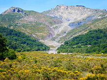
The Mount Scuderi, with its typical flat dolomitic peak
The Rocca di Novara dominates Fondachelli-Fantina valley.
in front of the Pizzo di Vernà from Fondachelli-Fantina
the Ritagli di Lecca from Fondachelli Fantina
The mountain Pizzo Russa lies in the territories of Fondachelli-Fantina and Novara di Sicilia
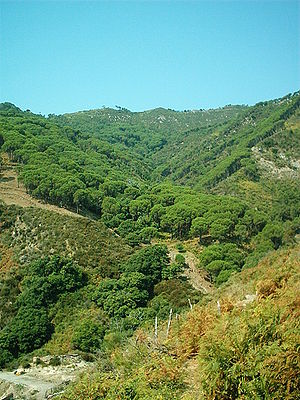
A pine forest in the territory of Mili San Pietro, in the comune of Messina

The Peloritani (Sicilian: Piluritani, Italian: Monti Peloritani) are a mountain range of north-eastern Sicily, in southern Italy, extending for some 65 km (40 mi) from Capo Peloro to the Nebrodi Mountains. On the north and east they are bordered by the Tyrrhenian and Ionian Seas respectively, and on the south by the Alcantara River .

The highest peaks are the Montagna Grande (1,374 m, 4,508 ft), the Rocca di Novara (1,340 m, 4,400 ft), the Pizzo di Vernà (1,287 m, 4,222 ft), the Monte Poverello (1,279 m, 4,196 ft) and the Monte Scuderi (1,253 m, 4,111 ft). The range is made up of a long series of peaks, with an average height of 800–1,000 m (2,600–3,300 ft), intermingled with ridges and ravines. The deep gorges house numerous streams that create the typical rivers of this land called fiumare, often full of deprises in their inferior flow. The most common rocks are of igneous and metamorphic origin. Sandstone soils are also present. Of unusual origin are the megaliths rocks of the Argimusco plateau.

Vegetation includes holm oak, oak, cork oak, beech, pine and chestnut, which once formed large forests but are now, mostly due to human presence, reduced to sparse woods so that the landscape is largely steppe-like. Several pine woods have been reconstituted by the local authorities since the 1950s. An ancient path, Dorsale dei Peloritani, runs along the ridge line from Monte Dinnammare above the Strait of Messina to the Rocca di Novara.

References

[edit]

38°03′N 15°20′E / 38.050°N 15.333°E / 38.050; 15.333


{{bottomLinkPreText}} {{bottomLinkText}}
Peloritani
Listen to this article

This browser is not supported by Wikiwand :(
Wikiwand requires a browser with modern capabilities in order to provide you with the best reading experience.
Please download and use one of the following browsers:

This article was just edited, click to reload
This article has been deleted on Wikipedia (Why?)

Back to homepage

Please click Add in the dialog above
Please click Allow in the top-left corner,
then click Install Now in the dialog
Please click Open in the download dialog,
then click Install
Please click the "Downloads" icon in the Safari toolbar, open the first download in the list,
then click Install
{{::$root.activation.text}}

Install Wikiwand

Install on Chrome Install on Firefox
Don't forget to rate us

Tell your friends about Wikiwand!

Gmail Facebook Twitter Link

Enjoying Wikiwand?

Tell your friends and spread the love:
Share on Gmail Share on Facebook Share on Twitter Share on Buffer

Our magic isn't perfect

You can help our automatic cover photo selection by reporting an unsuitable photo.

This photo is visually disturbing This photo is not a good choice

Thank you for helping!


Your input will affect cover photo selection, along with input from other users.

X

Get ready for Wikiwand 2.0 🎉! the new version arrives on September 1st! Don't want to wait?