Nendeln
Nendeln | |
|---|---|
Village | |
 | |
| Coordinates: 47°12′N 9°33′E / 47.200°N 9.550°E | |
| Country | |
| Electoral district | |
| Municipality | |
| Elevation | 450 m (1,480 ft) |
| Population (2003) | |
| • Total | 1,357[1] |
| Time zone | UTC+1 (CET) |
| • Summer (DST) | UTC+2 (CEST) |
| Postal code | 9485 |
| Area code | (+423) ... |
Nendeln is a village located in the municipality of Eschen in Liechtenstein.
History
[edit]Prior to the establishment of the village, the Roman Empire had a presence here. There, Villas from that time period have been excavated at Nendeln.[2]
During the War of the Second Coalition in 1799, the village was burned by invading French troops.[3] It was the starting location of 1939 Liechtenstein putsch, of the approximately 40 members of the VBDL who were intended to march towards Vaduz.[4]
Geography
[edit]The village is located in north-central Liechtenstein, on the main road Schaan-Schaanwald that links the country with Buchs (Switzerland) and Feldkirch (Austria). Villages that are closer to Nendeln are Schaanwald, Mauren, Eschen and Planken.[5]
Transport
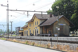
[edit]Nendeln has a railway station on the Feldkirch-Buchs line. The station is served by 22 trains per day, 11 in each direction between Switzerland and Austria. When the next station in the direction of Austria (Schaanwald) is not used, which has been the case since 2013, Nendeln is for customs purposes, a border station for passengers arriving from Austria. Liechtenstein is in a customs union with Switzerland. Customs checks may be performed in the station or on board trains by Swiss officials. Systematic passport controls were abolished when Liechtenstein joined the Schengen Area in 2011.[6]
References
[edit]- ^ (in German) 2003 population statistics of Eschen municipality
- ^ Baedeker, Karl (1891). The eastern Alps : including the Bavarian highlands, the Tyrol, Salzkammergut, Styria, Carinthia, Carniola, and Istria : handbook for travellers. London: Dulau. p. 265.
- ^ Wanner, Gerhard (31 December 2011). "Koalitionskriege". Historisches Lexikon des Fürstentums Liechtenstein (in German). Retrieved 28 September 2023.
- ^ Büchel, Donat (31 December 2011). "Anschlussputsch". Historisches Lexikon des Fürstentums Liechtenstein (in German). Retrieved 14 November 2023.
- ^ 240046176 Nendeln on OpenStreetMap
- ^ "No more controls on Swiss-Liechtenstein border".
External links
[edit]![]() Media related to Nendeln at Wikimedia Commons
Media related to Nendeln at Wikimedia Commons
Text is available under the CC BY-SA 4.0 license; additional terms may apply.
Images, videos and audio are available under their respective licenses.

