Muntendam
Muntendam | |
|---|---|
 Muntendam in 2011 | |
 Muntendam Location of Muntendam in the province of Groningen  Muntendam Muntendam (Netherlands) | |
| Coordinates: 53°8′1″N 6°52′7″E / 53.13361°N 6.86861°E | |
| Country | Netherlands |
| Province | Groningen |
| Municipality | Midden-Groningen |
| Area | |
| • Total | 12.88 km2 (4.97 sq mi) |
| Elevation | 2.2 m (7.2 ft) |
| Population (2021)[1] | |
| • Total | 4,635 |
| • Density | 360/km2 (930/sq mi) |
| Postal code | 9649[1] |
| Dialing code | 0598 |
Muntendam is a village in the municipality of Midden-Groningen, in the Dutch province of Groningen. The village has a population of 4,635 (2021). Muntendam had been an independent parish since the Middle Ages, but until 1840 it was ecclesiastically part of Zuidbroek.
From 1811 until 1990 it was a separate municipality, which boasted the title 'reddest (most socialist) municipality in the Netherlands', with a council of 11 containing 7 PvdA (Labour Party) members and 2 CPN (Communist Party) members. (However, nearby Reiderland had had a vast CPN majority since WWII, so the claim is rather too strong). When a new mayor had to be appointed in 1980 (at the time a municipality had no say in the matter), it was assumed that it would become a PvdA mayor as it had always been. However, the then minister of the interior, Hans Wiegel of the right-wing VVD, decided that this very left-wing part of the Netherlands needed a change and appointed a D66 (left of centre) mayor. This led to a cold reception and the first time a Dutch mayor was not officially inaugurated. Over time, however, people started to like him and when he moved to a bigger municipality there was even an action to keep him (to no avail). Not much later, the method of appointing a mayor in the Netherlands was changed, with the municipality putting up a request which is usually followed.
Gallery
[edit]-
 Protestant church
 -
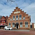 Former town hall
 -
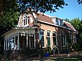 House in Muntendam
 -
 Street view
,_PKN-tsjerke.jpg)
,_it_%C3%A2lde_gemeenteh%C3%BBs_fan_de_gemeente_Muntendam.jpg)


References
[edit]- ^ a b c "Kerncijfers wijken en buurten 2021". Central Bureau of Statistics. Retrieved 9 April 2022.
four entries
- ^ "Postcodetool for 9649AA". Actueel Hoogtebestand Nederland (in Dutch). Het Waterschapshuis. Retrieved 9 April 2022.
External links
[edit] Media related to Muntendam at Wikimedia Commons
Populated places in the municipality of Midden-Groningen | |
|---|---|
| Towns | |
| Villages |
|
| Hamlets | |
| International | |
|---|---|
| National | |
| Geographic | |
Text is available under the CC BY-SA 4.0 license; additional terms may apply.
Images, videos and audio are available under their respective licenses.
