Munising Formation
| Munising Formation | |
|---|---|
| Stratigraphic range: Cambrian-?Early Ordovician | |
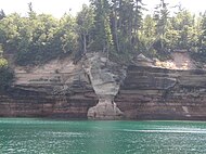
 Light-colored Musining Formation overlying the red Jacobsville Formation in Pictured Rocks National Lakeshore | |
| Type | Formation |
| Sub-units | Miner's Castle Member, Chapel Rock Member, Basal Conglomerate, Eau Claire Formation |
| Underlies | Au Train Formation |
| Overlies | Jacobsville Sandstone |
| Thickness | 1,700 ft (520 m) |
| Lithology | |
| Primary | Conglomerate |
| Other | Anhydrite |
| Location | |
| Region | |
| Country | |
The Munising Group or Formation is a 1,700 feet (520 m) thick, white to light grey[1] Cambrian sedimentary unit that crops out in Michigan and (to a lesser extent) Ontario. At one end of its extent, it comprises a basal conglomerate overlain by the Chapel Rock Member and the Miners Castle Member; elsewhere, it comprises the Eau Claire, Galesville (=Dresbach), and Franconia Members. Anhydritic evaporite deposits are present in places.[2] The conglomerate was deposited by rivers in flood, with the Chapel Rock member, which contains deltaic deposits, representing transgression as the conglomerate cones became submerged; the Miners Castle member was deposited further from the shoreline, representing shelf deposits.[3] Its uppermost strata may be Early Ordovician in age, and contain conodonts, trilobites and phosphatic moulds of brachiopods, ostrocoderm fish and gastropods.[4]
The Munising lies unconformably above the Jacobsville Formation.[1]
References
[edit]- ^ a b "Pictured Rocks: Geologic Formations". US National Park Service. Retrieved August 5, 2011.
- ^ Paul A. Catacosinos (1973). "Cambrian Lithostratigraphy of Michigan Basin". The American Association of Petroleum Geologists Bulletin. 57 (12): 2404–2418. doi:10.1306/83d9132b-16c7-11d7-8645000102c1865d.
- ^ Charles a. Haddox, R. H. D. (1990). "Cambrian Shoreline Deposits in Northern Michigan". SEPM Journal of Sedimentary Research. doi:10.1306/212F9250-2B24-11D7-8648000102C1865D.
- ^ Miller, J. F.; Ethington, R. L.; Rose, R. (2006). "Stratigraphic Implications of Lower Ordovician Conodonts from the Munising and Au Train Formations at Pictured Rocks National Lakeshore, Upper Peninsula of Michigan". PALAIOS. 21 (3): 227–237. doi:10.2110/palo.2004.p04-50.
| Ph |
|   | ||||||||||||||||||||||||||||||||||||||||||||||||||||||||||||
|---|---|---|---|---|---|---|---|---|---|---|---|---|---|---|---|---|---|---|---|---|---|---|---|---|---|---|---|---|---|---|---|---|---|---|---|---|---|---|---|---|---|---|---|---|---|---|---|---|---|---|---|---|---|---|---|---|---|---|---|---|---|---|
| pЄ |
| |||||||||||||||||||||||||||||||||||||||||||||||||||||||||||||
Text is available under the CC BY-SA 4.0 license; additional terms may apply.
Images, videos and audio are available under their respective licenses.
