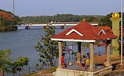
Mahé River
| Mahe River (Mayyazhipuzha) | |
|---|---|
 | |
| Location | |
| Country | India |
| Physical characteristics | |
| Source | |
| • location | Western Ghats |
| Mouth | |
• location | Arabian Sea |
| Length | 54 km (34 mi) |
| Basin size | 394 km2 (152 sq mi)[1] |
The Mahe River (Mayyazhipuzha) is a river in South India. It flows through the state of Kerala and the coastal exclave of Mahe in Puducherry.
The Mahe River originates in the slopes of the Western Ghats part of the Wayanad district. Initially, the river flows through the hilly eastern towns of the Kozhikode district like Vilangad, Vanimal, Jathiyeri and Nadapuram. Then, the river enters into the Malabar plains where it flows through several towns, including Parakkadavu, Kadavathur, Peringathur, Eramala, Kunnukara, Kariyad and Peringandoor.[2] The river then flows through the northern boundary of the Union Territory of Mahe and empties into the Arabian Sea.
Economy
[edit]There is very little influence on the economy of the region traversed by the river. The river has been used for inland navigation and transportation of articles from interior villages to Mahe and back in the past. The government of Puducherry has planned to build a fishing harbour at the estuary of the river. However, owing to technical reasons, the harbour (which is under construction) is on the beach adjacent to the estuary. To enhance tourist potential of Mahe, a riverside walkway (originating from the Water Sports Complex at Manjakkal, Mahe, on the banks of the river stretching out to the breakwater of the [Fishing Harbour]) is also being built by the government of Puducherry.[3]
Trivia
[edit]During the British Raj, the Mahe River was nicknamed the English Channel because it separated British-ruled Thalassery from French-ruled Mahe.
In popular culture
[edit]The river is mentioned in M. Mukundan's 1974 magnum opus novel Mayyazhippuzhayude Theerangalil (Malayalam for "On the banks of the Mahe River").
See also
[edit]References
[edit]- ^ "Rivers of Western Ghats". ernet.in. Archived from the original on 25 June 2018. Retrieved 18 January 2020.
- ^ "Official website of Kozhikode". Kozhikode. Government of Kerala. Archived from the original on 9 July 2007. Retrieved 6 August 2006.
- ^ "South Asia News". Works for Mahe fishing harbour project inaugurated. onlypunjab.com. Archived from the original on 27 September 2007. Retrieved 6 August 2006.
External links
[edit]Text is available under the CC BY-SA 4.0 license; additional terms may apply.
Images, videos and audio are available under their respective licenses.
