Magude District
Magude | |
|---|---|
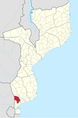
 Magude District on the map of Mozambique | |
| Country | Mozambique |
| Province | Maputo |
| Capital | Magude |
| Area | |
| • Total | 7,010 km2 (2,710 sq mi) |
| Population (2007 census) | |
| • Total | 53,317 |
| • Density | 7.6/km2 (20/sq mi) |
Magude District is a district of Maputo Province in southern Mozambique. The principal town is Magude. The district is located in the north of the province, and borders with Massingir and Chókwè Districts of Gaza Province in the north, Manhiça District in the east, Moamba District in the south, and with South Africa in the west. The area of the district is 7,010 square kilometres (2,710 sq mi).[1] It has a population of 53,317 as of 2007.[2]
Geography
[edit]The principal river in the district is the Komati River. Other rivers, such as the Mazimuchopes River, the Massintonto River, and the Uanétze River, are seasonal and only flow during the rainy season.[1]
The climate is subtropical dry, with the annual rainfall being 630 millimetres (25 in).[1]
History
[edit]The name Magude originates from Magudzo Cossa, a Xhosa king who was active in the area in the second half of the 19th century. Before 1874, the Magude Circunscrição, an administrative unit in colonial Portuguese Africa, was established, but the descendants of Magudzo Cossa retained the traditional role of the chiefs and were incorporated into the government.[1]
Demographics
[edit]As of 2005, 42% of the population of the district was younger than 15 years. 41% of the population spoke Portuguese. The most common mothertongue among the population was Xichangana. 59% were analphabetic, mostly women.[1]
Administrative divisions
[edit]The district is divided into five postos, Magude, Mapulanguene, Mahela, Motaze, and Panjane, which in total contain 18 localities.[1]
Economy
[edit]6% of the households in the district have access to electricity.[1]
Agriculture
[edit]In the district, there are 7,500 farms which have on average 2.3 hectares (0.0089 sq mi) of land. The main agricultural products are corn, cassava, cowpea, peanut, and sweet potato.[1]
Transportation
[edit]There is a road network in the district of the total length of 806 kilometres (501 mi), of which 41 kilometres (25 mi) are paved. There is a bridge over the Komati River, which requires a restoration.[1]
References
[edit]- ^ a b c d e f g h i "Perfil do Distrito de Magude" (PDF) (in Portuguese). Ministry of State Administration. 2005. Retrieved 30 October 2016.
- ^ "População da Provincia de Maputo". Censo 2007 (in Portuguese). Instituto Nacional de Estatística. Archived from the original on 20 February 2008. Retrieved 20 March 2008.
Further reading
[edit]- Heidi Gengenbach, "Binding Memories: Women as Makers and Tellers of History in Magude, Mozambique." Columbia U Press, 2004.
Districts of Mozambique by province | |
|---|---|
Capital: Maputo | |
| Cabo Delgado | |
| Gaza | |
| Inhambane | |
| Manica | |
| Maputo | |
| Nampula | |
| Niassa | |
| Sofala | |
| Tete | |
| Zambezia | |
Text is available under the CC BY-SA 4.0 license; additional terms may apply.
Images, videos and audio are available under their respective licenses.
