For faster navigation, this Iframe is preloading the Wikiwand page for M25 expressway (Hungary).

M25 expressway (Hungary)

This article includes a list of general references, but it lacks sufficient corresponding inline citations. Please help to improve this article by introducing more precise citations. (April 2020) (Learn how and when to remove this message)
.mw-parser-output .hidden-begin{box-sizing:border-box;width:100%;padding:5px;border:none;font-size:95%}.mw-parser-output .hidden-title{font-weight:bold;line-height:1.6;text-align:left}.mw-parser-output .hidden-content{text-align:left}@media all and (max-width:500px){.mw-parser-output .hidden-begin{width:auto!important;clear:none!important;float:none!important))You can help expand this article with text translated from the corresponding article in Hungarian. (April 2020) Click [show] for important translation instructions. View a machine-translated version of the Hungarian article. Machine translation, like DeepL or Google Translate, is a useful starting point for translations, but translators must revise errors as necessary and confirm that the translation is accurate, rather than simply copy-pasting machine-translated text into the English Wikipedia. Do not translate text that appears unreliable or low-quality. If possible, verify the text with references provided in the foreign-language article. You must provide copyright attribution in the edit summary accompanying your translation by providing an interlanguage link to the source of your translation. A model attribution edit summary is Content in this edit is translated from the existing Hungarian Wikipedia article at [[:hu:M25-ös autóút (Magyarország)]]; see its history for attribution. You may also add the template ((Translated|hu|M25-ös autóút (Magyarország))) to the talk page. For more guidance, see Wikipedia:Translation.
M25 expressway shield
M25 expressway
M25-ös autóút
Map key - blue in use Map key - grey other highways
M25 autóút.jpg
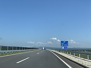
M25 near Eger
Route information
Length19 km (12 mi)
Existed2018–present
Major junctions
From M3 near Füzesabony
Major intersections
  • 3 near Kerecsend
  • 253 near Andornaktálya
To 252 in Eger
Location
CountryHungary
CountiesHeves
Major citiesEger
Highway system
  • Roads in Hungary

The M25 expressway (Hungarian: M25-ös autóút) is a short north–south highway in Hungary. It connects the M3 motorway to the city of Eger.

Timeline

[edit]
Section Length Opened Notes
Kál (M3) – Andornaktálya 14.5 km (9.01 mi) 20 July 2020 Segment South, built between 2018 – 2020.
Andornaktálya – Eger 4.0 km (2.49 mi) 7 November 2018 Segment North, built between 2017 – 2018.

Route description

[edit]
  • The route is full length expressway. The maximum speed limit is 110 km/h, with (2x2 lane road).
This article contains a bulleted list or table of intersections which should be presented in a properly formatted junction table. Please consult this guideline for information on how to create one. Please improve this article if you can. (November 2021)
County km Type Destination Notes

Heves
0 Interchange M3 / E71Budapest, Gyöngyös

M3 / E71Nyíregyháza, Miskolc (M30), Debrecen (M35)

The southern terminus of the Expressway expressway.

Kilometrage starting point


trumpet interchange

6 Bridge Laskó híd híd means Bridge
7 Exit Main road 3Kerecsend / Main road 33 – Füzesabony
10 Exit Main road 251 – Maklár, Bosch factory
15 Exit Main road 253 – Mezőkövesd, Andornaktálya
19 Roundabout Main road 252 – Eger Centrum, towards to Main road 25 → Ózd The northern terminus of the expressway.
1.000 mi = 1.609 km; 1.000 km = 0.621 mi

Maintenance

[edit]

The operation and maintenance of the road by Hungarian Concession Infrastructure Development Plc. This activity is provided by this highway engineer.

  • near Kál (M3), kilometre trench 103

Payment

[edit]

Hungarian system has 2 main type in terms of salary:

1, time-based fee vignettes (E-matrica);

  • Cars, vans and motorbikes up to 3.5 tonnes only need to buy a single vignette which costs 6,400 Hungarian forint (Ft) for 10 days, 10,360 Ft for 1 month and 57,260 Ft for a year, from 1 January 2024.[1]

2, county vignettes (Megyei matrica); the highway can be used instead of the national sticker with the following county stickers:

Type of county vignette Available section
Heves full length (0 km – 19 km)

See also

[edit]

References

[edit]
  1. ^ "National Toll Payment Services PLC - E-vignette rates from 1 January 2024". toll-charge.hu.
[edit]


{{bottomLinkPreText}} {{bottomLinkText}}
M25 expressway (Hungary)
Listen to this article

This browser is not supported by Wikiwand :(
Wikiwand requires a browser with modern capabilities in order to provide you with the best reading experience.
Please download and use one of the following browsers:

This article was just edited, click to reload
This article has been deleted on Wikipedia (Why?)

Back to homepage

Please click Add in the dialog above
Please click Allow in the top-left corner,
then click Install Now in the dialog
Please click Open in the download dialog,
then click Install
Please click the "Downloads" icon in the Safari toolbar, open the first download in the list,
then click Install
{{::$root.activation.text}}

Install Wikiwand

Install on Chrome Install on Firefox
Don't forget to rate us

Tell your friends about Wikiwand!

Gmail Facebook Twitter Link

Enjoying Wikiwand?

Tell your friends and spread the love:
Share on Gmail Share on Facebook Share on Twitter Share on Buffer

Our magic isn't perfect

You can help our automatic cover photo selection by reporting an unsuitable photo.

This photo is visually disturbing This photo is not a good choice

Thank you for helping!


Your input will affect cover photo selection, along with input from other users.

X

Get ready for Wikiwand 2.0 🎉! the new version arrives on September 1st! Don't want to wait?