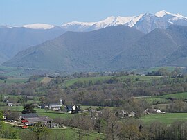
Lys, Pyrénées-Atlantiques
Lys | |
|---|---|
 General view of Lys | |
| Coordinates: 43°07′52″N 0°21′06″W / 43.1311°N 0.3517°W | |
| Country | France |
| Region | Nouvelle-Aquitaine |
| Department | Pyrénées-Atlantiques |
| Arrondissement | Oloron-Sainte-Marie |
| Canton | Oloron-Sainte-Marie-2 |
| Intercommunality | Vallée d'Ossau |
| Government | |
| • Mayor (2020–2026) | Nadège Poueymirou Bouchet[1] |
| Area 1 | 15.40 km2 (5.95 sq mi) |
| Population (2021)[2] | 323 |
| • Density | 21/km2 (54/sq mi) |
| Time zone | UTC+01:00 (CET) |
| • Summer (DST) | UTC+02:00 (CEST) |
| INSEE/Postal code | 64363 /64260 |
| Elevation | 304–510 m (997–1,673 ft) (avg. 424 m or 1,391 ft) |
| 1 French Land Register data, which excludes lakes, ponds, glaciers > 1 km2 (0.386 sq mi or 247 acres) and river estuaries. | |
Lys (French pronunciation: [lis]; Occitan: Lo Lis) is a commune in the Pyrénées-Atlantiques department in southwestern France.
Geography
[edit]Hydrography
[edit]The river Landistou, a 12.5 km long tributary of the Béez, passes through the village Lys. Several tributaries of the Landistou (Betbeder, Bonnasserre, Chourrup, Lazerau, Lespereu) also pass through the commune.[3] The northern part of the commune is drained by the river Luz, a 15.2 km long tributary of the Gave de Pau, and some of its tributaries (Gest, Herran, Luz de Casalis).[4] The southern part of the commune is drained by the stream Ruisseau de la Fontaine de Mesplé (Béez basin), and its tributary Ruisseau de Subercase.[5]
Localities and Hamlets
[edit]- lou Boscq
- Vic de Hoges de Baix
- Vic de Hoges de Haut
- Vic de Lis de Baix
- Vic de Lis de Haut
Surrounding Communities
[edit]- Sévignacq-Meyracq to the north
- Haut-de-Bosdarros to the northeast
- Bruges-Capbis-Mifaget to the east
- Sainte-Colome to the southwest
- Louvie-Juzon to the south
Toponymy
[edit]The name Lys appears as Lis-Sainte-Colomme (Lily Saint Colomme) from the 1721 census. The name comes from Gascony, and means 'flat land'.
History
[edit]Lys was formerly an annex of Sainte-Colome until it acquired municipality status in 1858.[6]
Administration
[edit]The current mayor is Nadège Poueymirou Bouchet, in office since 2020.[1]
The town is part of the following intercommunal structures:
- Communauté de communes de la Vallée d'Ossau (Ossau Valley)
- Syndicat de la perception d'Arudy
- SIVU d'assainissement (sanitation) de la vallée d'Ossau
- Ossau Valley water union
- Lower Ossau electric union
Population
[edit]
|
| ||||||||||||||||||||||||||||||||||||||||||||||||||||||||||||||||||||||||||||||||||||
| Source: EHESS[6] and INSEE (1968-2017)[7] | |||||||||||||||||||||||||||||||||||||||||||||||||||||||||||||||||||||||||||||||||||||
Economy
[edit]The town's economy is primarily oriented toward agriculture and livestock (sheep, cattle, pigs, mules).
See also
[edit]References
[edit]- ^ a b "Répertoire national des élus: les maires" (in French). data.gouv.fr, Plateforme ouverte des données publiques françaises. 13 September 2022.
- ^ "Populations légales 2021" (in French). The National Institute of Statistics and Economic Studies. 28 December 2023.
- ^ Sandre. "Fiche cours d'eau - Le Landistou (Q5010550)".
- ^ Sandre. "Fiche cours d'eau - Le Luz (Q5030500)".
- ^ Sandre. "Fiche cours d'eau - Ruisseau de la Fontaine de Mesplé (Q5000730)".
- ^ a b Des villages de Cassini aux communes d'aujourd'hui: Commune data sheet Lys, EHESS (in French).
- ^ Population en historique depuis 1968, INSEE
Text is available under the CC BY-SA 4.0 license; additional terms may apply.
Images, videos and audio are available under their respective licenses.


