Keonjhar State
| Keonjhar State କେନ୍ଦୁଝର | |||||||
|---|---|---|---|---|---|---|---|
| Vassal state of Maratha Confederacy (1751 - 1803) Princely State of British India | |||||||
| 12th century–1948 | |||||||
|
Flag | |||||||
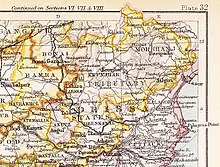
 Keonjhar State in the Imperial Gazetteer of India | |||||||
| Area | |||||||
• 1931 | 8,019 km2 (3,096 sq mi) | ||||||
| Population | |||||||
• 1931 | 460,609 | ||||||
| History | |||||||
• Established | 12th century | ||||||
| 1948 | |||||||
| |||||||
Keonjhar State (Odia: କେନ୍ଦୁଝର), also known as Keunjhar, was one of the princely states of India during the period of the British Raj.[1] The second largest of the states of the Orissa States Agency, it was located in present-day Kendujhar district, Odisha.

The state was bounded in the north by Singhbhum District, in the east by the State of Mayurbhanj and Balasore District, in the south by Dhenkanal State and Cuttack District, and in the west by the states of Pal Lahara and Bonai. The state consisted of two clearly differentiated areas: Low Keonjhar, a region of flat river valleys — the main river being the Baitarani, and the High Keonjhar, an area of forests dominated by mountain ranges with the Gandhamadan reaching a height of 1078 m. The capital was at Keonjhar. [2]
History
[edit]According to traditions, Keonjhar State was founded during the 12th century rule of the Eastern Ganga dynasty when the founder Jyoti Bhanja of the Bhanja dynasty, who was the brother of Adi Bhanja of Mayurbhanj, was enthroned as the Raja of Keonjhar with the help of the dominant local Bhuyan clans. The influence of the Bhuyans on the enthronement rituals and regnal traditions of Keonjhar suggests a long-standing relationship with the kingdom.[3][4]
Around the 14th century, a prince from Keonjhar named Ananga Bhanja, who was a nephew of the Raja of Keonjhar was named the king of Baudh by the local chieftains under Ganga rule.[5][6]
Maratha Rule
[edit]Chimna Sau marched to Keonjhar, where the Raja, accompanied by his diwan and vakil, came to pay his respects. Demonstrating loyalty and support, the Raja of Keonjhar provided 20,000 khandaits to bolster the Maratha forces. This substantial contribution of troops not only reinforced the Maratha military presence but also solidified the Raja's alliance with Chimna Sau, ensuring mutual cooperation and strengthening Maratha influence in the region.[7]
After the independence of India in 1947 Keonjhar merged into Republic of India on 1 January 1948[8] following which it became the part of Keonjhar district (now Kendujhar).
Rulers
[edit]The rulers of Keonjhar State of the Bhanja dynasty. The Keonjhar royal family adopted the emblems of the neighbouring State of Mayurbhanj, a peacock and the yellow and blue colours.[9]
- Jyoti Bhanja (12th cen CE)
- ...
- Jagannath Bhanja (1688 - 1700)
- Raghunath Bhanja (1700 - 1719)
- Gopinath Bhanja (1719 - 1736)
- Narsingh Narayan Bhanja (1736 - 1757)
- Daneswar Narayan Bhanja (1757 - 1758)
- Jagateswar Narayan Bhanja (1758 - 1762)
- Pratap Balbhadra Bhanja (1762 - 1794)
- Janardan Bhanja (1794 - 1825)
- Gadadhar Narayan Bhanj Deo (1825 - 22 March 1861)
- Dhanurjai Narayan Bhanj Deo (4 September 1861 – 27 October 1905)
- Gopinath Narayan Bhanj Deo (27 Oct 1905 – 12 August 1926)
- Balbhadra Narayan Bhanj Deo (12 Aug 1926 – 1 January 1948)
Titular
[edit]- Balbhadra Narayan Bhanj Deo (1 January 1948 – 1963)
- Nrusingh Narayan Bhanj Deo (1963 – 2016)
- Anant Narayan Bhanj Deo (2016 – 1 December 2019)
- Dhananjay Bhanj Deo (1 December 2019 – current)
See also
[edit]References
[edit]- ^ Chisholm, Hugh, ed. (1911). . Encyclopædia Britannica. Vol. 15 (11th ed.). Cambridge University Press. p. 749.
- ^ Imperial Gazetteer of India, v. 15, p. 202
- ^ Cornelia Mallebrein (2010), Sitting on the Tribal Chief’s Lap Coronation Rituals in Ex-Princely States of Orissa, University of Tubingen
- ^ "Princely states - Keonjhar". Archived from the original on 19 March 2019. Retrieved 24 July 2015.
- ^ ODISHA DISTRICT GAZETTEERS BOUDH (PDF), GAD, Govt of Odisha, 1991, p. 23
- ^ Imperial Gazetteer of India, v. 7, p. 140.
- ^ Ray, Bhabani Charan (1960). Orissa Under Marathas 1751-1803. p. 55.
- ^ Dr. Bhagyalipi Malla (August 2007). "Amalgamation of Princely States" (PDF). Orissa Review. p. 94,98. Retrieved 18 July 2013.
- ^ Princely States of India
21°38′N 81°36′E / 21.633°N 81.600°E
| Bengal States Agency | |
|---|---|
| Chhattisgarh States Agency | |
| Orissa States Agency | |
Text is available under the CC BY-SA 4.0 license; additional terms may apply.
Images, videos and audio are available under their respective licenses.

