Kent Downs
| Kent Downs | |
|---|---|
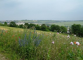
 Ranscombe Farm, Medway. In June, these 'unimproved' meadows are covered with chalk grassland flowers. | |
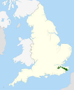
 Location of the Kent Downs AONB in the UK | |
| Location | Kent, England |
The Kent Downs is an Area of Outstanding Natural Beauty (AONB) in Kent, England.[1] They are the eastern half of the North Downs and stretch from the London/Surrey borders to the White Cliffs of Dover, including a small section of the London Borough of Bromley. The AONB also includes the Greensand Ridge, a prominent sandstone escarpment which lies south of the chalk escarpment of the North Downs.
It was first designated as an AONB in July 1968 and covers 878 square km (326 square miles).[2] The AONB's highest point is Toy's Hill, at 250m above sea level, and its boundaries include three main rivers: the Darent, Medway and Stour.[2]
To the west, Surrey Hills AONB adjoins the Kent Downs AONB, and includes a continuation of the North Downs chalk ridge which runs through the Kent Downs, stretching from Farnham to the English Channel and reappearing within the Parc Naturel Régional des Caps et Marais d’Opale in France.[2] High Weald AONB lies to the south east, separated by a distance of just over 2km at Bough Beech Reservoir.
As part of the management of the AONB, Village Design Statements have been adopted by 14 per cent of villages within its boundaries, going on to form part of Supplementary Planning Guidance, recognising the character of the historic landscape and distinctiveness of settlements.[3][4][2]
Areas
[edit]Among the named parts of the Downs are:
- Alkham Valley – a dry valley north-west of Dover;[5]
- Betsom's Hill – highest point in Kent at 251 metres (823 ft); near Westerham[6][7]
- Blue Bell Hill
- Burham Down
- Castle Hill
- Chartham Downs
- Denge Wood
- Detling Hill
- Elham Valley
- Hollingbourne Downs
- Knole Park
- Lullingstone Country Park
- Ranscombe Farm
- Samphire Hoe
- Summerhouse Hill
- Tolsford Hill
- Torry Hill
- Wye Downs
Walking
[edit]The North Downs Way runs through the full length of the AONB, the Stour Valley Walk passes through the east of the AONB, and the Greensand Way to the south of Sevenoaks.
References
[edit]- ^ The Kent Downs website
- ^ a b c d "Kent Downs Area of Outstanding Natural Beauty (AONB) Management Plan 2021-2026" (PDF).
- ^ Forsyth, Michael (4 September 2013). Understanding Historic Building Conservation. John Wiley & Sons. ISBN 978-1-118-80684-5.
- ^ Gallent, Nick; Juntti, Meri; Kidd, Sue; Shaw, Dave (14 January 2008). Introduction to Rural Planning. Routledge. ISBN 978-1-134-08634-4.
- ^ *walks/rides available in this Valley Archived 2007-05-02 at archive.today
- ^ Muir, Jonny (2011). The UK's County Tops: Reaching the top of 91 historic counties. Cicerone. p. 32. ISBN 9781849655538.
- ^ Simon Edwardes (2001). "Historic County Tops". The Mountains of England and Wales. Retrieved 20 April 2014.
External links
[edit]| East of England | ||
|---|---|---|
| East Midlands | ||
| North East | ||
| North West | ||
| South East | ||
| South West | ||
| West Midlands | ||
| Yorkshire and the Humber | ||
| ||
51°17′N 0°35′E / 51.29°N 0.58°E
Text is available under the CC BY-SA 4.0 license; additional terms may apply.
Images, videos and audio are available under their respective licenses.

