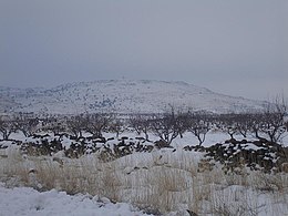
Jabal al-Druze

| Part of a series on
Druze |
|---|
 |
Jabal al-Druze (Arabic: جبل الدروز, romanized: jabal al-durūz, lit. 'Mountain of the Druze'), is an elevated volcanic region in the As-Suwayda Governorate of southern Syria.[1] Most of the inhabitants of this region are Druze, and there are also significant Christian communities.[2][3] Safaitic inscriptions were first found in this area. The State of Jabal Druze was an autonomous area in the French Mandate for Syria and the Lebanon from 1921 to 1936.[4][5] In the past, the name Jabal al-Druze was used for a different area, located in Mount Lebanon.[citation needed]
In Syria, most Druze reside in the As-Suwayda Governorate, which encompasses almost all of Jabal al-Druze. This governorate is unique in Syria as it has a Druze majority. Additionally, it has integrated Christian communities that have long coexisted harmoniously with the Druze in these mountain.[6]
In the 1980s Druze made up 87.6% of the population, Christians (mostly Greek Orthodox) 11% and Sunni Muslims 2%.[7] In 2010, the As-Suwayda governorate has a population of about 375,000 inhabitants, Druze made up 90%, Christians 7% and Sunni Muslims 3%.[2] Due to low birth and high emigration rates, Christians proportion in As-Suwayda had declined.[2]
Geology
[edit]
The Jabal al-Druze volcanic field, the southernmost in Syria, lies in the Haurun-Druze Plateau in SW Syria near the border with Jordan. The most prominent feature of this volcanic field is 1800m-high Jabal al-Druze (also known variously as Jabal ad Duruz, Djebel Al-Arab, Jabal Druze, Djebel ed Drouz). The alkaline volcanic field consists of a group of 118 basaltic volcanoes active from the lower-Pleistocene to the Holocene (2.6 million years ago to present). The large SW Plateau depression is filled by basaltic lava flows from volcanoes aligned in a NW-SE direction. This volcanic field lies within the northern part of the massive alkaline Harrat al-Sham (also known as Harrat al-Shaam) volcanic field that extends from southern Syria to Saudi Arabia.[8]
Peaks
[edit]- Tell Qeni (1,803 m)
- Tell Joualine (1,732 m)
- Tell Sleiman (1,703 m)
- Tell Qleib (1,698 m)
- Tell Abou-Hamra (1,482 m)
- Tell El-Ahmar (1,452 m)
- Tell Abed-Mar (1,436 m)
- Tell Khodr-Imtan (1,341 m)
- Tell Azran (1,220 m)
- Tell Shihan (1,138 m)
In Arabic, the word "tell" means "mound" or "hill", but in Jabal al-Druze it rather refers to a volcanic cone.
See also
[edit]References
[edit]- ^ "Mount al-Durūz | Lebanon, Anti-Lebanon Range, Summit | Britannica". www.britannica.com. Retrieved 2024-07-22.
- ^ a b c The Druze and Assad: Strategic Bedfellows
- ^ "Christians in Syria's Suwayda discuss history, coexistence with Druze majority". North Press. 18 September 2020.
- ^ "11. French Syria (1919-1946)". uca.edu. Retrieved 2024-07-22.
- ^ "French Mandate for Syria and the Lebanon". The American Journal of International Law. 17 (3): 177–182. 1923. doi:10.2307/2212963. ISSN 0002-9300. JSTOR 2212963.
- ^ Balanche, Fabrice (2017). Atlas of the Near East: State Formation and the Arab-Israeli Conflict, 1918–2010. Brill. p. 27. ISBN 9789004345188.
...comprised 50,328 inhabitants, of whom 85 per cent were Druze, and it integrated Christian communities (7,000 people) who had long lived in these mountains in harmony with the Druze.
- ^ Pipes, Daniel (1990). Greater Syria: The History of an Ambition. Oxford University Press. p. 151. ISBN 978-0-19-506021-8.
- ^ Krienitz, M.-S.; Haase, K. M.; Mezger, K.; Shaikh-Mashail, M. A. (August 2007). "Magma Genesis and Mantle Dynamics at the Harrat Ash Shamah Volcanic Field (Southern Syria)". Journal of Petrology. 48 (8). Oxford University Press: 1513–1542. doi:10.1093/petrology/egm028. Retrieved 2024-07-22.
| Beliefs | ||
|---|---|---|
| Important figures | ||
| Texts |
| |
| Holy places |
| |
| Holy days | ||
| History |
| |
| Prophets | ||
| Relationship with other religions |
| |
| Druze communities | ||
| Other Features | ||
Text is available under the CC BY-SA 4.0 license; additional terms may apply.
Images, videos and audio are available under their respective licenses.
