Jánoshalma District
Jánoshalma District
Jánoshalmai járás | |
|---|---|
 Coat of arms | |
 Jánoshalma District within Hungary and Bács-Kiskun County. | |
| Country | |
| County | Bács-Kiskun |
| District seat | Jánoshalma |
| Area | |
| • Total | 439.03 km2 (169.51 sq mi) |
| • Rank | 10th in Bács-Kiskun |
| Population (2011 census) | |
| • Total | 17,341 |
| • Rank | 11th in Bács-Kiskun |
| • Density | 39/km2 (100/sq mi) |
Jánoshalma (Hungarian: Jánoshalmai járás) is a district in southern part of Bács-Kiskun County. Jánoshalma is also the name of the town where the district seat is found. The district is located in the Southern Great Plain Statistical Region.
Geography
Jánoshalma District borders with Kiskőrös District to the north, Kiskunhalas District to the north and east, Bácsalmás District to the south, Baja District to the west, Kalocsa District to the northwest. The number of the inhabited places in Jánoshalma District is 5.
Municipalities
The district has 2 towns and 3 villages. (ordered by population, as of 1 January 2013)[1]
- Borota (1,431)
- Jánoshalma (8,941) – district seat
- Kéleshalom (453)
- Mélykút (5,165)
- Rém (1,306)
The bolded municipalities are cities.
Demographics
Religion in Jánoshalma District (2011 census)
In 2011, it had a population of 17,341 and the population density was 39/km2.
| Year | County population[2] | Change |
|---|---|---|
| 2011 | 17,341 | n/a |
Ethnicity
Besides the Hungarian majority, the main minorities are the Roma (approx. 800) and German (150).
Total population (2011 census): 17,341
Ethnic groups (2011 census):[3] Identified themselves: 16,200 persons:
- Hungarians: 15,160 (93.58%)
- Gypsies: 767 (4.73%)
- Others and indefinable: 273 (1.69%)
Approx. 1,000 persons in Jánoshalma District did not declare their ethnic group at the 2011 census.
Religion
Religious adherence in the county according to 2011 census:[4]
- Catholic – 11,378 (Roman Catholic – 11,360; Greek Catholic – 15);
- Reformed – 273;
- Evangelical – 42;
- other religions – 247;
- Non-religious – 1,414;
- Atheism – 80;
- Undeclared – 3,907.
Gallery
-
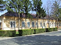 Jánoshalma, Town Hall
 -
 Park in Mélykút
 -
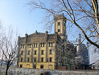 Historic Mill of Upper Bácska (Jánoshalma)
 -
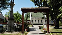
 St. Joachim Church in Mélykút


Text is available under the CC BY-SA 4.0 license; additional terms may apply.
Images, videos and audio are available under their respective licenses.
