Indian, Anchorage
Indian
Indian Valley | |
|---|---|
Unincorporated community | |
 Indian | |
| Country | United States |
| State | Alaska |
| Borough | Municipality of Anchorage |
| Time zone | UTC-9 (AKST) |
| • Summer (DST) | UTC-8 (AKDT) |
| ZIP code | 99540 |
| Area code | 907 |
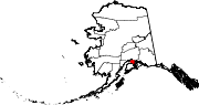
Indian (also known as Indian Valley) is a community in the Municipality of Anchorage, Alaska, United States. It lies in a valley in the Chugach Mountains near the middle of the north shore of the Turnagain Arm of Cook Inlet. It is about 24 miles (39 km) southeast of downtown Anchorage and about 3 miles (4.8 km) northwest of Bird, and about 13 miles (21 km) west-northwest of Girdwood.
Description
[edit]The community is located just west of Indian Creek and north of the Seward Highway within the Indian Valley. (The Seward Highway provides the only roadway access to Indian.)[1] Although not part of the Chugach State Park, the community is entirely surrounded by the park.[2]
Although the Alaska Railroad passes through the southern edge of the community (and has a siding that runs most of the length of community) none of the railroad's regular passenger trains stop in Indian. However, there are two special event trains that operate out of the Anchorage station that turn around (reverse direction) in Indian before returning to Anchorage. These two trains include the annual Easter Train and the Holiday Train (which runs twice each day on selected Saturdays in December).[3][4] Neither train allows passengers to disembark in Indian.
The origin of the community (and currently one of the main attractions) is the Indian Valley Mine. The mine was established 1920 and is currently listed on the National Register of Historic Places.[5]
Climate
[edit]Indian Creek Pass rises out of Indian to the north, up the Indian Valley and into the Chugach Mountains.[6] Indian Creek Pass has a subalpine climate (Köppen Dfc).
| Climate data for Indian Pass, Alaska, 1991–2020 normals, 1981-2020 extremes: 2350ft (716m) | |||||||||||||
|---|---|---|---|---|---|---|---|---|---|---|---|---|---|
| Month | Jan | Feb | Mar | Apr | May | Jun | Jul | Aug | Sep | Oct | Nov | Dec | Year |
| Record high °F (°C) | 54 (12) |
48 (9) |
53 (12) |
64 (18) |
72 (22) |
79 (26) |
82 (28) |
82 (28) |
68 (20) |
53 (12) |
46 (8) |
46 (8) |
82 (28) |
| Mean maximum °F (°C) | 36 (2) |
37 (3) |
43 (6) |
52 (11) |
63 (17) |
70 (21) |
72 (22) |
69 (21) |
57 (14) |
46 (8) |
38 (3) |
36 (2) |
72 (22) |
| Mean daily maximum °F (°C) | 23.7 (−4.6) |
25.5 (−3.6) |
30.5 (−0.8) |
40.7 (4.8) |
50.1 (10.1) |
56.8 (13.8) |
59.4 (15.2) |
56.9 (13.8) |
48.2 (9.0) |
35.6 (2.0) |
27.1 (−2.7) |
25.6 (−3.6) |
40.0 (4.5) |
| Daily mean °F (°C) | 18.8 (−7.3) |
20.3 (−6.5) |
23.0 (−5.0) |
32.5 (0.3) |
41.8 (5.4) |
48.6 (9.2) |
52.3 (11.3) |
50.2 (10.1) |
42.3 (5.7) |
31.0 (−0.6) |
22.4 (−5.3) |
20.7 (−6.3) |
33.7 (0.9) |
| Mean daily minimum °F (°C) | 13.7 (−10.2) |
15.2 (−9.3) |
15.5 (−9.2) |
24.3 (−4.3) |
33.5 (0.8) |
40.4 (4.7) |
45.4 (7.4) |
43.4 (6.3) |
36.3 (2.4) |
26.3 (−3.2) |
17.5 (−8.1) |
15.8 (−9.0) |
27.3 (−2.6) |
| Mean minimum °F (°C) | −9 (−23) |
−5 (−21) |
−1 (−18) |
11 (−12) |
25 (−4) |
33 (1) |
39 (4) |
36 (2) |
27 (−3) |
11 (−12) |
−1 (−18) |
−2 (−19) |
−14 (−26) |
| Record low °F (°C) | −36 (−38) |
−27 (−33) |
−18 (−28) |
−8 (−22) |
16 (−9) |
28 (−2) |
34 (1) |
29 (−2) |
14 (−10) |
−6 (−21) |
−18 (−28) |
−13 (−25) |
−36 (−38) |
| Average precipitation inches (mm) | 3.75 (95) |
3.95 (100) |
3.25 (83) |
2.69 (68) |
1.56 (40) |
1.40 (36) |
2.99 (76) |
6.13 (156) |
6.71 (170) |
5.10 (130) |
4.76 (121) |
4.75 (121) |
47.04 (1,196) |
| Source 1: XMACIS2[7] | |||||||||||||
| Source 2: NOAA (Precipitation)[8] | |||||||||||||
See also
[edit]References
[edit]- ^ Google (November 10, 2015). "Indian, Anchorage, AK" (Map). Google Maps. Google. Retrieved November 10, 2015.
- ^ "Chugach State Park" (PDF) (Map). dnr.alaska.gov. 1:80,000. Cartography by Martin Stahl. Alaska Department of Natural Resources: Division of Parks & Outdoor Recreation. December 12, 2009. Retrieved November 10, 2015.
- ^ "Easter Train". alaskarailroad.com. Alaska Railroad. Archived from the original on June 30, 2015. Retrieved November 13, 2015 – via archive.web.org.
- ^ "Holiday Train". alaskarailroad.com. Alaska Railroad. Retrieved November 13, 2015.
- ^ "Asset Detail: Indian Valley Mine". nps.gov. National Park Service. Retrieved November 10, 2015.
- ^ "Indian Creek Pass". Alaska Guide. Retrieved November 7, 2023.
- ^ "xmACIS2". National Oceanic and Atmospheric Administration. Retrieved November 7, 2023.
- ^ "Indian Pass, Alaska 1991-2020 Monthly Normals". Retrieved November 7, 2023.
External links
[edit]- Indian Valley Mine (official website)
Neighborhoods of The Municipality of Anchorage, Alaska, United States | ||
|---|---|---|
| Neighborhoods |
|  |
| Ghost towns | ||
60°59′N 149°31′W / 60.99°N 149.51°W
Text is available under the CC BY-SA 4.0 license; additional terms may apply.
Images, videos and audio are available under their respective licenses.
