Huliyurdurga
Huliyurdurga | |
|---|---|
Village | |
 Kumbi Betta | |
 Huliyurdurga Location in Karnataka, India  Huliyurdurga Huliyurdurga (India) | |
| Coordinates: 12°49′N 77°02′E / 12.817°N 77.033°E | |
| Country | |
| State | Karnataka |
| District | Tumkur |
| Talukas | Kunigal |
| Population (2001) | |
| • Total | 8,399 |
| Languages | |
| • Official | Kannada |
| Time zone | UTC+5:30 (IST) |
Huliyurdurga is a village in the state of Karnataka, India.[1][2] It is located in the Kunigal taluk of Tumakuru district of Karnataka.
Demographics
[edit]As of 2011 India census, Huliyurdurga had a population of 7989 with 4034 males and 3955 females.[3]
Geography
[edit]Huliyurdurga is:
- 60 km south of Tumkur,
- 22 km south of Kunigal and
- 30 km from Ramanagara.
It is now the headquarters of the hobli of the same name. It was the headquarters of the taluk of the same name till 1873. It is situated at the foot of the hill of the same name. The Huliyurdurga hill is shaped like an inverted cup.
The fort on the hill is 845 meters above mean sea level and is said to have been erected by Kempe Gowda, the Magadi chief. The fort has ruins of:
- Springs,
- Houses,
- Gunpowder magazines,
- Granaries,
- A Durbar Hall
and other structures (remains of).
A temple close to this hill is said to have been built by Kempe Gowda or by Chikkadevaraya Wodeyar. It has carved granite pillars in the Navaranga. The temple of Mallikarjuna is situated on the summit of Hemagiri hill, which is beside Huliyurdurga. A shrine of Varadaraja, locally known as Hemagiriyappa, where the object of worship is a round stone, is on the eastern slope of Hemagiri. The southern slope has a shrine of Bhairava. Hemagiri hill is higher than Huliyurdurga but has no fort.
Gallery
[edit]-
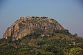 Kumbi Betta - A view from Hemagiri
 -
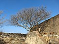 Ruins of fort on top of Kumbi Betta
 -
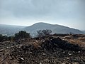 A view of Hemagiri Hill from Kumbi Betta
 -
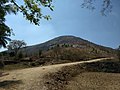
 A View of Huliyur Durga City from top of Kumbi Betta
 -
 Hemagiri Hill


See also
[edit]References
[edit]- ^ Village code= 1696600 "Census of India : Villages with population 5000 & above". Registrar General & Census Commissioner, India. Archived from the original on 8 December 2008. Retrieved 18 December 2008.
- ^ "Yahoomaps India". Archived from the original on 18 December 2008. Retrieved 18 December 2008. Huliyurdurga, Tumkur, Karnataka
- ^ "Huliyurdurga Population (2021/2022), Village in Kunigal Taluka". www.indiagrowing.com. Retrieved 23 March 2022.
3.Karnataka State Gazetteer 1983.
External links
[edit]District HQ: Tumkur | |
| Villages and Towns |
|
Text is available under the CC BY-SA 4.0 license; additional terms may apply.
Images, videos and audio are available under their respective licenses.
