Hohenleipisch
Hohenleipisch | |
|---|---|
 Coat of arms | |
Location of Hohenleipisch within Elbe-Elster district 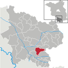 | |
 Hohenleipisch  Hohenleipisch | |
| Coordinates: 51°30′00″N 13°33′00″E / 51.50000°N 13.55000°E | |
| Country | Germany |
| State | Brandenburg |
| District | Elbe-Elster |
| Municipal assoc. | Plessa |
| Government | |
| • Mayor (2024–29) | Lutz Schumann[1] |
| Area | |
| • Total | 34.81 km2 (13.44 sq mi) |
| Elevation | 135 m (443 ft) |
| Population (2022-12-31)[2] | |
| • Total | 2,005 |
| • Density | 58/km2 (150/sq mi) |
| Time zone | UTC+01:00 (CET) |
| • Summer (DST) | UTC+02:00 (CEST) |
| Postal codes | 04934 |
| Dialling codes | 03533 |
| Vehicle registration | EE, FI, LIB |
Hohenleipisch (Sorbian: Lubuš) is a municipality in the Elbe-Elster district, in Brandenburg, Germany.
History
[edit]Two kilometres west of Hohenleipisch is an old brown coal and quartz sand pit called Grube Gotthold.
From 1952 to 1990, Hohenleipisch was part of the Bezirk Cottbus of East Germany.
Demography
[edit]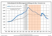
|
|
|
|
References
[edit]- ^ Landkreis Elbe-Elster Wahl der Bürgermeisterin / des Bürgermeisters. Retrieved 27 June 2024.
- ^ "Bevölkerungsentwicklung und Bevölkerungsstandim Land Brandenburg Dezember 2022" (PDF). Amt für Statistik Berlin-Brandenburg (in German). June 2023.
- ^ Detailed data sources are to be found in the Wikimedia Commons.Population Projection Brandenburg at Wikimedia Commons
Towns and municipalities in Elbe-Elster | ||
|---|---|---|
|  | |
| International | |
|---|---|
| National | |
Text is available under the CC BY-SA 4.0 license; additional terms may apply.
Images, videos and audio are available under their respective licenses.
Cover photo is available under {{::mainImage.info.license.name || 'Unknown'}} license.
Cover photo is available under {{::mainImage.info.license.name || 'Unknown'}} license.
Credit:
(see original file).
