Haighton
| Haighton | |
|---|---|
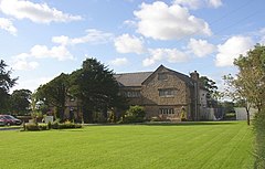
 Haighton Manor | |
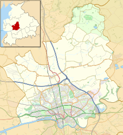
Location within Lancashire | |
| Population | 202 (2011) |
| OS grid reference | SD566349 |
| Civil parish |
|
| District | |
| Shire county | |
| Region | |
| Country | England |
| Sovereign state | United Kingdom |
| Post town | PRESTON |
| Postcode district | PR2 |
| Dialling code | 01772 |
| Police | Lancashire |
| Fire | Lancashire |
| Ambulance | North West |
| UK Parliament | |
Haighton is a civil parish in the City of Preston, Lancashire, England. It is a rural area north east of the urban city of Preston, beyond Fulwood and Brookfield.
Geography
[edit]Haighton also contains the hamlets of Haighton Green and Haighton Top. It is separated from the city by the M6 motorway, with junction 31A on the boundary with Brookfield.
Community
[edit]The area was intended to become a residential suburb as part of the Central Lancashire New Town, with population increasing to 29,100 by 2001[1] however it never occurred and the area has remained rural. It has a population of 197,[2] increasing to 202 at the 2011 Census.[3]
Economy
[edit]The listed building of Haighton Manor[4][circular reference] has operated as a country pub and restaurant since the early 1970s, undergoing substantial renovation in the mid 2010s and now operated by Brunning and Price.
History
[edit]The parish was part of Preston Rural District throughout its existence from 1894 to 1974.[5] In 1974 the parish became part of the Borough of Preston, which became a city in 2002.
See also
[edit]References
[edit]- ^ Central Lancashire Development Corporation outline plan, 1974. ISBN 0-904335-00-3
- ^ UK Census (2001). "Local Area Report – Haighton Parish (30UK005)". Nomis. Office for National Statistics. Retrieved 27 May 2019.
- ^ UK Census (2011). "Local Area Report – Haighton Parish (E04005238)". Nomis. Office for National Statistics. Retrieved 27 May 2019.
- ^ Listed buildings in Haighton
- ^ Preston RD, Vision of Britain, accessed 9 June 2014
External links
[edit]Geography of the City of Preston district | |||||||
|---|---|---|---|---|---|---|---|
| Cities | |||||||
| Suburbs | |||||||
| Villages | |||||||
| Parishes | |||||||
| Topography |
| ||||||
| Unitary authorities | |
|---|---|
| Boroughs or districts | |
| Major settlements (cities in italics) |
|
| Rivers | |
| Canals | |
| Topics | |
Text is available under the CC BY-SA 4.0 license; additional terms may apply.
Images, videos and audio are available under their respective licenses.


