File:Xaver Bodil surface map 2013-12-05-12UTC.gif
Size of this preview: 500 × 600 pixels. Other resolutions: 200 × 240 pixels | 400 × 480 pixels | 640 × 768 pixels.
Original file (640 × 768 pixels, file size: 99 KB, MIME type: image/gif)
| This is a file from the Wikimedia Commons. Information from its description page there is shown below. Commons is a freely licensed media file repository. You can help. |
Summary
| Description |
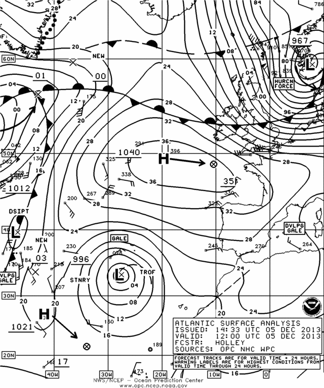
English: Surface weather map of Eastern Atlantic coast whem cyclone Bodil was passing in the North Sea on December 5th, 2013 at 12 UTC.
Français : Carte météorologique du 5 décembre 2013 à 12 UTC lorsque la tempête Bodil traversait la mer du Nord en Europe. |
| Date | |
| Source | http://nomads.ncdc.noaa.gov/ncep/NCEP |
| Author | National Centers for Environmental Prediction of NOAA |
Licensing
This image is in the public domain because it contains materials that originally came from the U.S. National Oceanic and Atmospheric Administration, taken or made as part of an employee's official duties.
|
File history
Click on a date/time to view the file as it appeared at that time.
| Date/Time | Thumbnail | Dimensions | User | Comment | |
|---|---|---|---|---|---|
| current | 13:42, 7 December 2013 | | 640 × 768 (99 KB) | Pierre cb | ((Information |Description =((en|1=Surface weather map of Eastern Atlantic coast whem cyclone Bodil was passing in the North Sea on December 5th, 2013 at 12 UTC.)) ((fr|1=Carte météorologique du 5 décembre 2013 à 12 UTC lor... |
File usage
The following pages on the English Wikipedia use this file (pages on other projects are not listed):
Global file usage
The following other wikis use this file:
- Usage on de.wikipedia.org
- Usage on fr.wikipedia.org
- Usage on zh.wikipedia.org
Text is available under the CC BY-SA 4.0 license; additional terms may apply.
Images, videos and audio are available under their respective licenses.
Cover photo is available under {{::mainImage.info.license.name || 'Unknown'}} license.
Cover photo is available under {{::mainImage.info.license.name || 'Unknown'}} license.
Credit:
(see original file).
