For faster navigation, this Iframe is preloading the Wikiwand page for File:Map Staten Island Railway en.png.

File:Map Staten Island Railway en.png
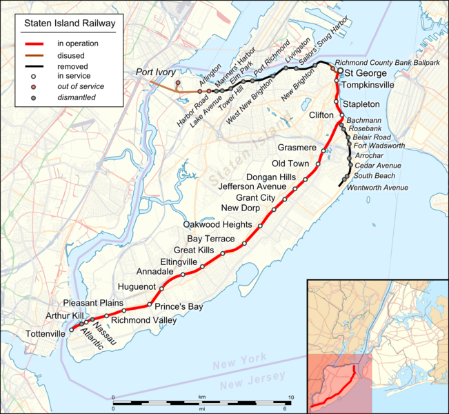
Original file(1,885 × 1,737 pixels, file size: 2.4 MB, MIME type: image/png)

Description
English: Location map of Staten Island Railway. English Index
Date
Source
Creator
 Geotemporal data
Bounding box
N: 40.6801444°N
W: 74.3002352°W E: 73.9998772°W
S: 40.4700369°N
Georeferencing View the georeferenced map in the Wikimaps Warper
Other versions
German Index
I, the copyright holder of this work, hereby publish it under the following license:
w:en:Creative Commons
attribution
This file is licensed under the Creative Commons Attribution 3.0 Unported license.
You are free:
  • to share – to copy, distribute and transmit the work
  • to remix – to adapt the work
Under the following conditions:
  • attribution – You must give appropriate credit, provide a link to the license, and indicate if changes were made. You may do so in any reasonable manner, but not in any way that suggests the licensor endorses you or your use.
This work is licensed under the Open Database License (summary).

Captions

Add a one-line explanation of what this file represents

Items portrayed in this file

depicts

image/png

File history

Click on a date/time to view the file as it appeared at that time.

Date/TimeThumbnailDimensionsUserComment
current19:22, 17 August 2023Thumbnail for version as of 19:22, 17 August 20231,885 × 1,737 (2.4 MB)DinoSoupCanadaConnected into NJ
02:11, 29 April 2018Thumbnail for version as of 02:11, 29 April 20181,885 × 1,737 (2.25 MB)Pechristenerkorr: Atlantic and Nassau stops were demolished
01:55, 29 April 2018Thumbnail for version as of 01:55, 29 April 20181,885 × 1,737 (2.25 MB)Pechristenertypos / Arthur Kill station
08:09, 22 November 2016Thumbnail for version as of 08:09, 22 November 20161,885 × 1,737 (1.57 MB)Kopiersperreoptipng
03:41, 22 November 2016Thumbnail for version as of 03:41, 22 November 20161,885 × 1,737 (2.27 MB)Pechristener((Map |Description=((en|1=Location map of ((w|Staten Island Railway)). English Index)) |Source= * [http://www.openstreetmap.org/ Open Street Map] Data * ((f|USA_New_York_City_location_map.svg)) (for location map) |Author= * rendering with Maperitive,...

File usage

The following pages on the English Wikipedia use this file (pages on other projects are not listed):

Global file usage

The following other wikis use this file:

{{bottomLinkPreText}} {{bottomLinkText}}
File:Map Staten Island Railway en.png
Listen to this article

This browser is not supported by Wikiwand :(
Wikiwand requires a browser with modern capabilities in order to provide you with the best reading experience.
Please download and use one of the following browsers:

This article was just edited, click to reload
This article has been deleted on Wikipedia (Why?)

Back to homepage

Please click Add in the dialog above
Please click Allow in the top-left corner,
then click Install Now in the dialog
Please click Open in the download dialog,
then click Install
Please click the "Downloads" icon in the Safari toolbar, open the first download in the list,
then click Install
{{::$root.activation.text}}

Install Wikiwand

Install on Chrome Install on Firefox
Don't forget to rate us

Tell your friends about Wikiwand!

Gmail Facebook Twitter Link

Enjoying Wikiwand?

Tell your friends and spread the love:
Share on Gmail Share on Facebook Share on Twitter Share on Buffer

Our magic isn't perfect

You can help our automatic cover photo selection by reporting an unsuitable photo.

This photo is visually disturbing This photo is not a good choice

Thank you for helping!


Your input will affect cover photo selection, along with input from other users.

X

Get ready for Wikiwand 2.0 🎉! the new version arrives on September 1st! Don't want to wait?