For faster navigation, this Iframe is preloading the Wikiwand page for File:Location map United Kingdom Southport.svg.

File:Location map United Kingdom Southport.svg
Original file(SVG file, nominally 1,094 × 1,228 pixels, file size: 3.69 MB)

Summary

Description
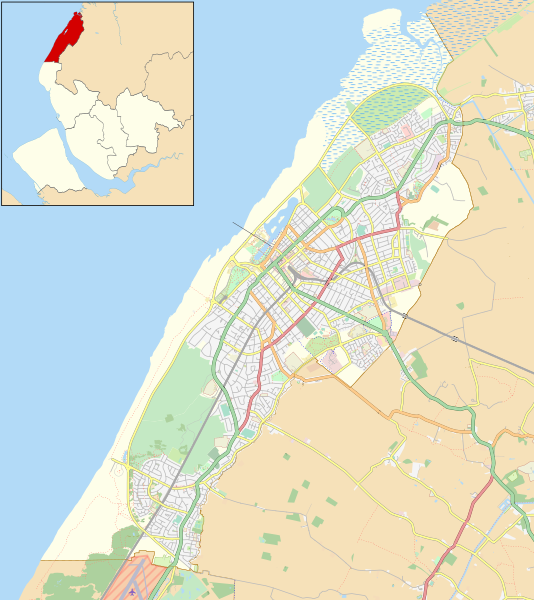
English: Map of Southport, Merseyside, England. Inset shows location within Merseyside.

Equirectangular map projection on WGS 84 datum.

Geographic limits:

  • West: 3.10° W
  • East: 2.92° W
  • North: 53.70° N
  • South: 53.58° N
Date
Source

This file was derived from: Southport unparished area UK locator map.svg

Author
Other versions Location map United Kingdom Southport Central.svg for Southport town centre

Licensing

This work contains information from OpenStreetMap, which is made available under the Open Database License (ODbL).

The ODbL does not require any particular license for maps produced from ODbL data. Prior to 1 August 2020, map tiles produced by the OpenStreetMap Foundation were licensed under the CC-BY-SA-2.0 license. Maps produced by other people may be subject to other licences.

w:en:Creative Commons
attribution share alike
This file is licensed under the Creative Commons Attribution-Share Alike 4.0 International license.
Attribution: © OpenStreetMap contributors. Contains Ordnance Survey data © Crown copyright and database right 2015.
You are free:
  • to share – to copy, distribute and transmit the work
  • to remix – to adapt the work
Under the following conditions:
  • attribution – You must give appropriate credit, provide a link to the license, and indicate if changes were made. You may do so in any reasonable manner, but not in any way that suggests the licensor endorses you or your use.
  • share alike – If you remix, transform, or build upon the material, you must distribute your contributions under the same or compatible license as the original.

Captions

Add a one-line explanation of what this file represents

Items portrayed in this file

depicts

11 April 2017

File history

Click on a date/time to view the file as it appeared at that time.

Date/TimeThumbnailDimensionsUserComment
current22:30, 11 April 2017Thumbnail for version as of 22:30, 11 April 20171,094 × 1,228 (3.69 MB)Dr GregUser created page with UploadWizard

File usage

Global file usage

The following other wikis use this file:

Metadata

{{bottomLinkPreText}} {{bottomLinkText}}
File:Location map United Kingdom Southport.svg
Listen to this article

This browser is not supported by Wikiwand :(
Wikiwand requires a browser with modern capabilities in order to provide you with the best reading experience.
Please download and use one of the following browsers:

This article was just edited, click to reload
This article has been deleted on Wikipedia (Why?)

Back to homepage

Please click Add in the dialog above
Please click Allow in the top-left corner,
then click Install Now in the dialog
Please click Open in the download dialog,
then click Install
Please click the "Downloads" icon in the Safari toolbar, open the first download in the list,
then click Install
{{::$root.activation.text}}

Install Wikiwand

Install on Chrome Install on Firefox
Don't forget to rate us

Tell your friends about Wikiwand!

Gmail Facebook Twitter Link

Enjoying Wikiwand?

Tell your friends and spread the love:
Share on Gmail Share on Facebook Share on Twitter Share on Buffer

Our magic isn't perfect

You can help our automatic cover photo selection by reporting an unsuitable photo.

This photo is visually disturbing This photo is not a good choice

Thank you for helping!


Your input will affect cover photo selection, along with input from other users.

X

Get ready for Wikiwand 2.0 🎉! the new version arrives on September 1st! Don't want to wait?