For faster navigation, this Iframe is preloading the Wikiwand page for File:Laguna de Términos.jpeg.

File:Laguna de Términos.jpeg
Original file(8,797 × 5,865 pixels, file size: 6.89 MB, MIME type: image/jpeg)

Summary

Description

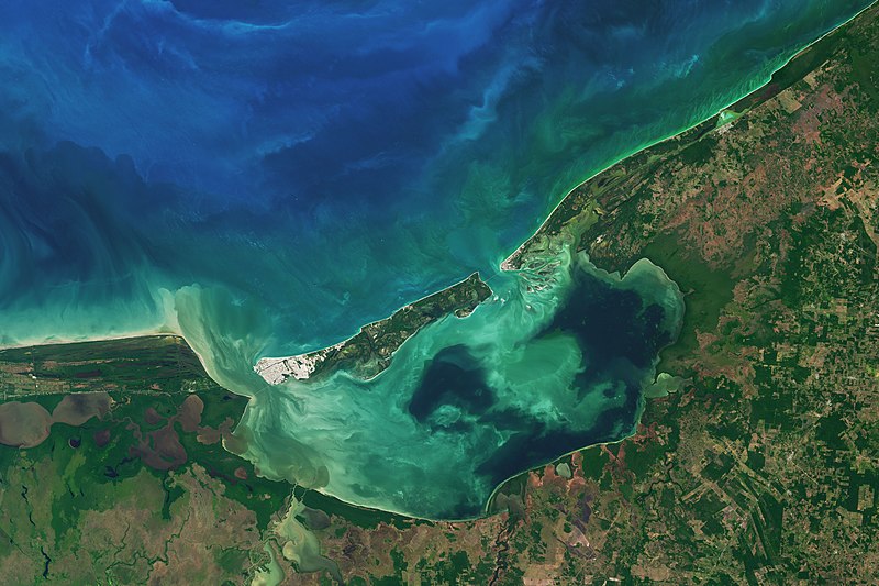
Along the coast of southeast Mexico, in the state of Campeche, wetlands and rivers give way to a shallow, swirling body of water. At 2500 square kilometers, Laguna de Términos is Mexico’s largest coastal lagoon.

By definition, coastal lagoons maintain a connection to the sea through a restricted inlet. At Laguna de Términos, the flow of water between the lagoon and the Campeche Sound is impeded by Isla del Carmen, a 2.5-kilometer-wide barrier island. This arrangement means this lagoon has two inlets (or outlets): Sea water generally flows into the lagoon around the east of the island, and out past the western end.

Campeche and its lagoon receive a healthy input of fresh water from a huge system of rivers flowing from the nearby states of Tabasco, Chiapas, and Guatemala. The flow varies depending on the season. When the Operational Land Imager (OLI) on the Landsat 8 satellite captured this image on January 20, 2017, the region was in the dry season, which runs from October through February.

Four major river systems drain the watershed and feed the lagoon from the south and southwest, the largest of which is the Usumacinta River. Even in the dry season, these areas of the lagoon are fresher than other parts and more turbid—visible in this image as colorful swirls near the shore. Winds and tides also can stir up lagoon waters.

Life is abundant here. Oyster beds thrive at the mouths of the major rivers. Beds of seagrass take hold in the saltier, calmer areas, particularly off of Isla del Carmen. And ringing much of the lagoon are uninterrupted patches of mangrove wetlands. The detailed image shows one such area on the eastern side of the lagoon. The mangroves and lagoon serve as a nursery for fish and shellfish, such as shrimp, which in turn support productive commercial fisheries in Campeche Sound.
Date
Source https://earthobservatory.nasa.gov/images/90893/laguna-de-terminos
Author NASA Earth Observatory images by Joshua Stevens, using Landsat data from the U.S. Geological Survey. Story by Kathryn Hansen.

Licensing

Public domain This file is in the public domain in the United States because it was solely created by NASA. NASA copyright policy states that "NASA material is not protected by copyright unless noted". (See Template:PD-USGov, NASA copyright policy page or JPL Image Use Policy.)
Warnings:

Captions

Add a one-line explanation of what this file represents

Items portrayed in this file

depicts

20 January 2017

image/jpeg

File history

Click on a date/time to view the file as it appeared at that time.

Date/TimeThumbnailDimensionsUserComment
current04:05, 12 March 2021Thumbnail for version as of 04:05, 12 March 20218,797 × 5,865 (6.89 MB)StellarHalo((Information |Description=Along the coast of southeast Mexico, in the state of Campeche, wetlands and rivers give way to a shallow, swirling body of water. At 2500 square kilometers, Laguna de Términos is Mexico’s largest coastal lagoon. By definition, coastal lagoons maintain a connection to the sea through a restricted inlet. At Laguna de Términos, the flow of water between the lagoon and the Campeche Sound is impeded by Isla del Carmen, a 2.5-kilometer-wide barrier island. This arrangeme...

File usage

The following pages on the English Wikipedia use this file (pages on other projects are not listed):

Global file usage

The following other wikis use this file:

Metadata

{{bottomLinkPreText}} {{bottomLinkText}}
File:Laguna de Términos.jpeg
Listen to this article

This browser is not supported by Wikiwand :(
Wikiwand requires a browser with modern capabilities in order to provide you with the best reading experience.
Please download and use one of the following browsers:

This article was just edited, click to reload
This article has been deleted on Wikipedia (Why?)

Back to homepage

Please click Add in the dialog above
Please click Allow in the top-left corner,
then click Install Now in the dialog
Please click Open in the download dialog,
then click Install
Please click the "Downloads" icon in the Safari toolbar, open the first download in the list,
then click Install
{{::$root.activation.text}}

Install Wikiwand

Install on Chrome Install on Firefox
Don't forget to rate us

Tell your friends about Wikiwand!

Gmail Facebook Twitter Link

Enjoying Wikiwand?

Tell your friends and spread the love:
Share on Gmail Share on Facebook Share on Twitter Share on Buffer

Our magic isn't perfect

You can help our automatic cover photo selection by reporting an unsuitable photo.

This photo is visually disturbing This photo is not a good choice

Thank you for helping!


Your input will affect cover photo selection, along with input from other users.

X

Get ready for Wikiwand 2.0 🎉! the new version arrives on September 1st! Don't want to wait?