File:C+B-Geography-Map1-StrabosMap.PNG
Size of this preview: 800 × 393 pixels. Other resolutions: 320 × 157 pixels | 640 × 315 pixels | 1,024 × 503 pixels | 1,566 × 770 pixels.
Original file (1,566 × 770 pixels, file size: 695 KB, MIME type: image/png)
| This is a file from the Wikimedia Commons. Information from its description page there is shown below. Commons is a freely licensed media file repository. You can help. |
Summary
| Description |
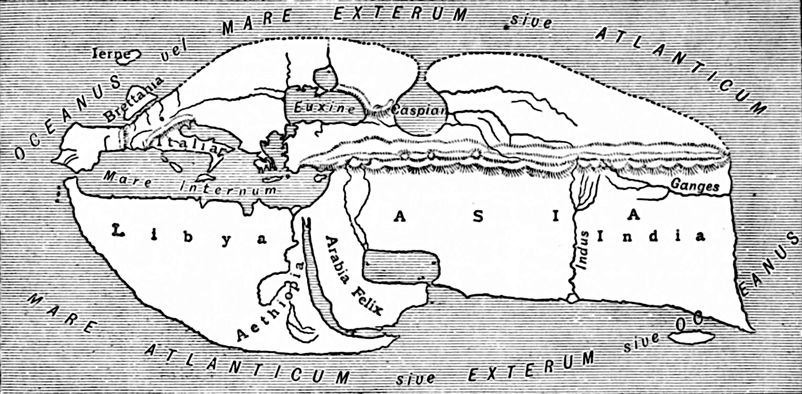
English: An illustration from the Encyclopaedia Biblica, a 1903 publication which is now in the public domain.
Map 1 for article "Geography". Map of the world, by Strabo |
||
| Date | |||
| Source | An illustration from the Encyclopaedia Biblica, a 1903 publication which is now in the public domain | ||
| Author | no idea - see source (though, ultimately Strabo) | ||
| Permission (Reusing this file) |
|
Licensing
This media file is in the public domain in the United States. This applies to U.S. works where the copyright has expired, often because its first publication occurred prior to January 1, 1929, and if not then due to lack of notice or renewal. See this page for further explanation.
|
 | |
 |
This image might not be in the public domain outside of the United States; this especially applies in the countries and areas that do not apply the rule of the shorter term for US works, such as Canada, Mainland China (not Hong Kong or Macao), Germany, Mexico, and Switzerland. The creator and year of publication are essential information and must be provided. See Wikipedia:Public domain and Wikipedia:Copyrights for more details.
|
File history
Click on a date/time to view the file as it appeared at that time.
| Date/Time | Thumbnail | Dimensions | User | Comment | |
|---|---|---|---|---|---|
| current | 19:34, 24 May 2020 | | 1,566 × 770 (695 KB) | Mikeroetto | Fresh extract from IA scans. Normalized and sharpened. |
| 20:57, 23 April 2011 |  | 728 × 353 (54 KB) | Hardwigg | Optimized with [http://www.pngoptimizer.com/ pngoptimizer.com/] | |
| 13:56, 21 October 2009 |  | 728 × 353 (90 KB) | Newman Luke | ((Information |Description=((en|1=An illustration from the Encyclopaedia Biblica, a 1903 publication which is now in the public domain. Map 1 for article "Geography". Map of the world, by Strabo)) |Source=An illustr |
File usage
The following pages on the English Wikipedia use this file (pages on other projects are not listed):
Global file usage
The following other wikis use this file:
- Usage on af.wikipedia.org
- Usage on bg.wikipedia.org
- Usage on el.wikipedia.org
- Usage on eo.wikipedia.org
- Usage on es.wikipedia.org
- Usage on fi.wikipedia.org
- Usage on fr.wikipedia.org
- Usage on he.wikipedia.org
- Usage on hu.wikipedia.org
- Usage on id.wikipedia.org
- Usage on ja.wikibooks.org
- Usage on ka.wikipedia.org
- Usage on la.wikipedia.org
- Usage on lt.wikipedia.org
- Usage on nn.wikipedia.org
- Usage on pt.wikipedia.org
- Usage on ru.wikipedia.org
- Usage on sk.wikipedia.org
- Usage on xmf.wikipedia.org
Metadata
Text is available under the CC BY-SA 4.0 license; additional terms may apply.
Images, videos and audio are available under their respective licenses.
Cover photo is available under {{::mainImage.info.license.name || 'Unknown'}} license.
Cover photo is available under {{::mainImage.info.license.name || 'Unknown'}} license.
Credit:
(see original file).
