For faster navigation, this Iframe is preloading the Wikiwand page for File:Bayou des allemands 2003.jpg.

File:Bayou des allemands 2003.jpg
Original file(1,500 × 951 pixels, file size: 428 KB, MIME type: image/jpeg)

Description
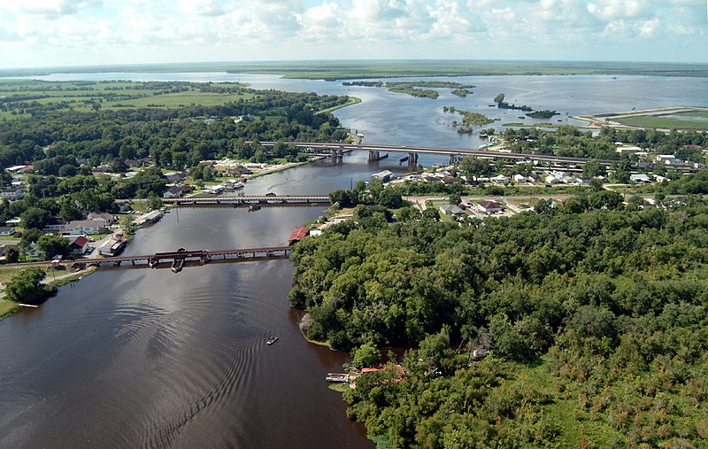
English: Bayou des Allemands and the town of Des Allemands, Louisiana, USA. The bayou empties into Dufrene Ponds (right, top) and Petit Lac Des Allemands (left, top). The bayou is the boundary between St. Charles Parish (left) and Lafourche Parish (right). The three bridges crossing the bayou are (closest to farthest): A railroad bridge, Louisiana State Route 631, and U.S. Route 90. View is to the south.
Date
Source U.S. Army Corps of Engineers Digital Visual Library
Image page
Image description page
Digital Visual Library home page
Author Lane Lefort, U.S. Army Corps of Engineers
Permission
(Reusing this file)
Public domain
This image or file is a work of a U.S. Army Corps of Engineers soldier or employee, taken or made as part of that person's official duties. As a work of the U.S. federal government, the image is in the public domain.

English | italiano | Nederlands | پښتو | русский | sicilianu | slovenščina | Türkçe | українська | +/−

Other versions en:Image:Bayou des allemands 2003.jpg
Location
InfoField
Des Allemands, Louisiana, USA
Camera location29° 49′ 31.57″ N, 90° 28′ 36.06″ W Kartographer map based on OpenStreetMap.View this and other nearby images on: OpenStreetMapinfo

Captions

Add a one-line explanation of what this file represents

Items portrayed in this file

depicts

10 July 2003

29°49'31.570"N, 90°28'36.059"W

image/jpeg

8e51adc0db29bad9d9880459e0e623b275e89696

437,941 byte

951 pixel

1,500 pixel

File history

Click on a date/time to view the file as it appeared at that time.

Date/TimeThumbnailDimensionsUserComment
current22:21, 7 April 2007Thumbnail for version as of 22:21, 7 April 20071,500 × 951 (428 KB)DanMS((Information | Description = ((en|Bayou des Allemands and the town of Des Allemands, Louisiana, USA. The bayou empties into Dufrene Ponds (right, top) and Petit Lac Des Allemands (left, top). The bayou is the boundary between St. Charles Parish (left)

File usage

The following pages on the English Wikipedia use this file (pages on other projects are not listed):

Global file usage

The following other wikis use this file:

Metadata

{{bottomLinkPreText}} {{bottomLinkText}}
File:Bayou des allemands 2003.jpg
Listen to this article

This browser is not supported by Wikiwand :(
Wikiwand requires a browser with modern capabilities in order to provide you with the best reading experience.
Please download and use one of the following browsers:

This article was just edited, click to reload
This article has been deleted on Wikipedia (Why?)

Back to homepage

Please click Add in the dialog above
Please click Allow in the top-left corner,
then click Install Now in the dialog
Please click Open in the download dialog,
then click Install
Please click the "Downloads" icon in the Safari toolbar, open the first download in the list,
then click Install
{{::$root.activation.text}}

Install Wikiwand

Install on Chrome Install on Firefox
Don't forget to rate us

Tell your friends about Wikiwand!

Gmail Facebook Twitter Link

Enjoying Wikiwand?

Tell your friends and spread the love:
Share on Gmail Share on Facebook Share on Twitter Share on Buffer

Our magic isn't perfect

You can help our automatic cover photo selection by reporting an unsuitable photo.

This photo is visually disturbing This photo is not a good choice

Thank you for helping!


Your input will affect cover photo selection, along with input from other users.

X

Get ready for Wikiwand 2.0 🎉! the new version arrives on September 1st! Don't want to wait?