File:Aerial view of Rose Bowl Cricket Ground - geograph.org.uk - 690412.jpg
No higher resolution available.
Aerial_view_of_Rose_Bowl_Cricket_Ground_-_geograph.org.uk_-_690412.jpg (640 × 525 pixels, file size: 82 KB, MIME type: image/jpeg)
| This is a file from the Wikimedia Commons. Information from its description page there is shown below. Commons is a freely licensed media file repository. You can help. |
Summary
| Description |
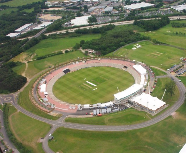
English: Aerial view of Rose Bowl Cricket Ground Taken during a birthday flying lesson.Courtesy of my son. |
| Date | |
| Source | From geograph.org.uk |
| Author | Colin Babb |
| Attribution (required by the license) | Colin Babb / Aerial view of Rose Bowl Cricket Ground / |
| Camera location | | View this and other nearby images on: OpenStreetMap |
|---|
| Object location | | View this and other nearby images on: OpenStreetMap |
|---|
Licensing

|
This image was taken from the Geograph project collection. See this photograph's page on the Geograph website for the photographer's contact details. The copyright on this image is owned by Colin Babb and is licensed for reuse under the Creative Commons Attribution-ShareAlike 2.0 license.
|
This file is licensed under the Creative Commons Attribution-Share Alike 2.0 Generic license.
Attribution: Colin Babb
- You are free:
- to share – to copy, distribute and transmit the work
- to remix – to adapt the work
- Under the following conditions:
- attribution – You must give appropriate credit, provide a link to the license, and indicate if changes were made. You may do so in any reasonable manner, but not in any way that suggests the licensor endorses you or your use.
- share alike – If you remix, transform, or build upon the material, you must distribute your contributions under the same or compatible license as the original.
File history
Click on a date/time to view the file as it appeared at that time.
| Date/Time | Thumbnail | Dimensions | User | Comment | |
|---|---|---|---|---|---|
| current | 04:14, 8 February 2011 | | 640 × 525 (82 KB) | GeographBot | == ((int:filedesc)) == ((Information |description=((en|1=Aerial view of Rose Bowl Cricket Ground Taken during a birthday flying lesson.Courtesy of my son.)) |date=2004-06-05 |source=From [http://www.geograph.org.uk/photo/690412 geograph.org.uk] |author=[h |
File usage
The following pages on the English Wikipedia use this file (pages on other projects are not listed):
Global file usage
The following other wikis use this file:
- Usage on ta.wikipedia.org
- Usage on ur.wikipedia.org
Text is available under the CC BY-SA 4.0 license; additional terms may apply.
Images, videos and audio are available under their respective licenses.
Cover photo is available under {{::mainImage.info.license.name || 'Unknown'}} license.
Cover photo is available under {{::mainImage.info.license.name || 'Unknown'}} license.
Credit:
(see original file).
