Dyleň
| Dyleň | |
|---|---|
 | |
| Highest point | |
| Elevation | 940 m (3,080 ft) |
| Prominence | 336 m (1,102 ft) |
| Isolation | 10.4 km (6.5 mi) |
| Coordinates | 49°58′4″N 12°30′10″E / 49.96778°N 12.50278°E |
| Geography | |
| Location | Karlovy Vary Region, Czech Republic |
| Parent range | Upper Palatinate Forest |
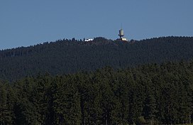
Dyleň (German: Tillenberg) is a mountain in the Karlovy Vary Region of the Czech Republic. At 940 metres (3,080 ft) above sea level, its summit is the second-highest peak in the Upper Palatinate Forest.
The summit is located in the Stará Voda municipality. It lies about 600 metres (2,000 ft) east of the Czech Republic–Germany border.
Local tradition holds that Napoleon Bonaparte declared Tillenberg the geographical midpoint of Europe in 1813.[1]
The German name provided the title of the epic poem Der Tillenberg: Ein Sagenschatz aus dem Egerlande (A Treasury of Tales from the Egerland) published in 1904 by Ernst Freimut (pseudonym of Johann (Hans) Sommert).[2]
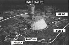
On the summit is a set of prominent buildings, which were used by the Soviet Union for electronic espionage into Germany during the Cold War. Now it is a radio and television transmission tower.
Geography and climate
[edit]
Dyleň has a humid continental climate (Köppen Dfb). The annual average temperature is 6.0 °C (42.8 °F), the hottest month in August is 15.4 °C (59.7 °F), and the coldest month is −3.0 °C (26.6 °F) in January. The annual precipitation is 746.4 millimetres (29.39 in), of which July is the wettest with 89.0 millimetres (3.50 in), while February is the driest with only 38.9 millimetres (1.53 in). The extreme temperature throughout the year ranged from −21.3 °C (−6.3 °F) on 7 February 2012 to 32.4 °C (90.3 °F) on 13 August 2003.
| Climate data for Dyleň, 1991–2020 normals, extremes 1998–present | |||||||||||||
|---|---|---|---|---|---|---|---|---|---|---|---|---|---|
| Month | Jan | Feb | Mar | Apr | May | Jun | Jul | Aug | Sep | Oct | Nov | Dec | Year |
| Record high °C (°F) | 11.9 (53.4) |
14.6 (58.3) |
18.8 (65.8) |
23.2 (73.8) |
28.2 (82.8) |
31.7 (89.1) |
32.0 (89.6) |
32.4 (90.3) |
26.7 (80.1) |
21.1 (70.0) |
16.0 (60.8) |
12.6 (54.7) |
32.4 (90.3) |
| Mean daily maximum °C (°F) | −1.0 (30.2) |
0.1 (32.2) |
4.0 (39.2) |
10.2 (50.4) |
14.4 (57.9) |
18.1 (64.6) |
19.5 (67.1) |
19.8 (67.6) |
14.3 (57.7) |
8.8 (47.8) |
3.4 (38.1) |
0.1 (32.2) |
9.3 (48.7) |
| Daily mean °C (°F) | −3.0 (26.6) |
−2.4 (27.7) |
0.9 (33.6) |
6.0 (42.8) |
10.1 (50.2) |
13.7 (56.7) |
15.2 (59.4) |
15.4 (59.7) |
10.8 (51.4) |
6.0 (42.8) |
1.3 (34.3) |
−2.1 (28.2) |
6.0 (42.8) |
| Mean daily minimum °C (°F) | −5.0 (23.0) |
−4.6 (23.7) |
−1.8 (28.8) |
2.5 (36.5) |
6.5 (43.7) |
9.9 (49.8) |
11.5 (52.7) |
12.0 (53.6) |
8.0 (46.4) |
3.6 (38.5) |
−0.6 (30.9) |
−4.1 (24.6) |
3.1 (37.6) |
| Record low °C (°F) | −21.1 (−6.0) |
−21.3 (−6.3) |
−17.5 (0.5) |
−10.4 (13.3) |
−3.4 (25.9) |
0.5 (32.9) |
3.5 (38.3) |
3.0 (37.4) |
−0.4 (31.3) |
−10.4 (13.3) |
−14.2 (6.4) |
−20.0 (−4.0) |
−21.3 (−6.3) |
| Average precipitation mm (inches) | 53.7 (2.11) |
38.9 (1.53) |
47.3 (1.86) |
43.2 (1.70) |
68.3 (2.69) |
75.1 (2.96) |
89.0 (3.50) |
81.2 (3.20) |
74.4 (2.93) |
60.6 (2.39) |
58.6 (2.31) |
56.0 (2.20) |
746.4 (29.39) |
| Average snowfall cm (inches) | 39.5 (15.6) |
28.3 (11.1) |
21.4 (8.4) |
6.0 (2.4) |
0.1 (0.0) |
0.0 (0.0) |
0.0 (0.0) |
0.0 (0.0) |
0.1 (0.0) |
3.1 (1.2) |
15.3 (6.0) |
28.0 (11.0) |
141.8 (55.8) |
| Average relative humidity (%) | 93.7 | 89.5 | 82.0 | 72.0 | 72.3 | 72.3 | 72.0 | 71.4 | 80.7 | 89.4 | 93.4 | 93.5 | 81.8 |
| Source: Czech Hydrometeorological Institute[3][4][5][6][7] | |||||||||||||
References
[edit]- ^ "Upper Palatinate: a Unique Place". Oberpfalz.de. Archived from the original on 2008-03-30. Retrieved 2009-04-18.
- ^ Švandrlík, Richard (January 31, 2001). "Osobnosti Mariánských Lázní". Hamelika (in Czech). Vol. XXV, no. 311. Retrieved 2009-04-18.
- ^ "Teplota vzduchu v jednotlivé kalendářní dny (Extremes)" (in Czech). Czech Hydrometeorological Institute. Archived from the original on 2024-09-09. Retrieved 2024-09-09.
- ^ "Průměrná teplota vzduchu v jednotlivé měsíce v jednotlivé roky (Temperatures)" (in Czech). Czech Hydrometeorological Institute. Archived from the original on 2024-09-09. Retrieved 2024-09-09.
- ^ "Srážkové úhrny v jednotlivé měsíce v jednotlivé roky (Precipitation)" (in Czech). Czech Hydrometeorological Institute. Archived from the original on 2024-09-09. Retrieved 2024-09-09.
- ^ "Množství nového sněhu v jednotlivé měsíce v jednotlivé roky (Snowfall)" (in Czech). Czech Hydrometeorological Institute. Archived from the original on 2024-09-09. Retrieved 2024-09-09.
- ^ "Průměrná relativní vlhkost vzduchu v jednotlivé měsíce v jednotlivé roky (Humidity)" (in Czech). Czech Hydrometeorological Institute. Archived from the original on 2024-09-09. Retrieved 2024-09-09.
External links
[edit]
Text is available under the CC BY-SA 4.0 license; additional terms may apply.
Images, videos and audio are available under their respective licenses.

