Darnétal
Darnétal | |
|---|---|
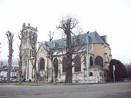
 The church of Carville | |
| Coordinates: 49°26′43″N 1°09′07″E / 49.4453°N 1.1519°E | |
| Country | France |
| Region | Normandy |
| Department | Seine-Maritime |
| Arrondissement | Rouen |
| Canton | Darnétal |
| Intercommunality | Métropole Rouen Normandie |
| Government | |
| • Mayor (2020–2026) | Christian Lecerf[1] |
| Area 1 | 4.93 km2 (1.90 sq mi) |
| Population (2021)[2] | 9,738 |
| • Density | 2,000/km2 (5,100/sq mi) |
| Time zone | UTC+01:00 (CET) |
| • Summer (DST) | UTC+02:00 (CEST) |
| INSEE/Postal code | 76212 /76160 |
| Elevation | 13–143 m (43–469 ft) (avg. 22 m or 72 ft) |
| 1 French Land Register data, which excludes lakes, ponds, glaciers > 1 km2 (0.386 sq mi or 247 acres) and river estuaries. | |
Darnétal (French pronunciation: [daʁnetal]; Norman: Dernétal) is a commune in the Seine-Maritime department in the Normandy region in northern France.
Geography
[edit]A light industrial suburban town surrounded by woodland, situated some 2 miles (3.2 km) east of the centre of Rouen at the junction of the D43, D15 and the N31 roads. Two small rivers flow through the town, the Robec and the Aubette.
SNCF operates a TER service, having a railway station in the town.
Heraldry
[edit] |
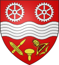
The arms of Darnétal are blazoned : Gules, a fess wavy [river] between two gear wheels argent and, in base, a printers stamp between, to dexter a weaver's shuttle and its bobbin in saltire, and to sinister a ?linen? shuttle with its ?teasel? in saltire Or.
|
Population
[edit]| Year | Pop. | ±% p.a. |
|---|---|---|
| 1968 | 11,062 | — |
| 1975 | 11,765 | +0.88% |
| 1982 | 10,081 | −2.18% |
| 1990 | 9,779 | −0.38% |
| 1999 | 9,225 | −0.65% |
| 2007 | 9,429 | +0.27% |
| 2012 | 9,418 | −0.02% |
| 2017 | 9,707 | +0.61% |
| Source: INSEE[3] | ||
Places of interest
[edit]- The churches of St.Ouen and of St.Pierre, both dating from the sixteenth century.
- Traces of a feudal castle.
- A restored watermill.
Notable people
[edit]- The activist René Valentin Binet, (1913–1957) was born here.
- Blessed Father Jacques Hamel (1930-2016), first priest to be killed by ISIL in Europe.
See also
[edit]References
[edit]- ^ "Répertoire national des élus: les maires" (in French). data.gouv.fr, Plateforme ouverte des données publiques françaises. 13 September 2022.
- ^ "Populations légales 2021" (in French). The National Institute of Statistics and Economic Studies. 28 December 2023.
- ^ Population en historique depuis 1968, INSEE
External links
[edit]- Official Darnétal website (in French)
- Darnétal Festival website (in French)
Text is available under the CC BY-SA 4.0 license; additional terms may apply.
Images, videos and audio are available under their respective licenses.


