Chodová Planá
Chodová Planá | |
|---|---|
 Main square | |
| Coordinates: 49°53′39″N 12°43′51″E / 49.89417°N 12.73083°E | |
| Country | |
| Region | Plzeň |
| District | Tachov |
| First mentioned | 1319 |
| Area | |
| • Total | 55.24 km2 (21.33 sq mi) |
| Elevation | 537 m (1,762 ft) |
| Population (2024-01-01)[1] | |
| • Total | 1,982 |
| • Density | 36/km2 (93/sq mi) |
| Time zone | UTC+1 (CET) |
| • Summer (DST) | UTC+2 (CEST) |
| Postal code | 348 13 |
| Website | www |
Chodová Planá (German: Kuttenplan) is a market town in the Tachov District in the Plzeň Region of the Czech Republic. It has about 2,000 inhabitants.
Administrative parts
[edit]The villages of Boněnov, Dolní Kramolín, Holubín, Hostíčkov, Michalovy Hory, Pístov and Výškov are administrative parts of Chodová Planá.
Geography
[edit]Chodová Planá is located about 12 kilometres (7 mi) northeast of Tachov and 49 km (30 mi) northwest of Plzeň. Most of the municipal territory lies in the Teplá Highlands, but the western part with the built-up area lies in the Upper Palatinate Forest Foothills. The highest point is at 748 m (2,454 ft) above sea level.
There are several fishponds in the vicinity of the market town. The largest of them is Regent, a 64 ha (160-acre) pond used for sports and recreational purposes.[2] The pond was founded in 1479.[3]
History
[edit]
The first written mention of Chodová Planá is from 1319, when it was a property of the knights Ctibor and Oldřich. It was then owned by various knights, and in 1391 and 1413 it was documented as the property of the Teplá Abbey. Its owners often changed until 1560, when Chodová Planá was bought by the Širtingar (German: Schirnding) family.[3]
After the Battle of White Mountain in 1620, the properties of the Širtingar family were confiscated, and Chodová Planá was acquired by the counts of Haimhausen. The estate remained in their possession until the abolition of serfdom in 1848. In 1733, a huge fire destroyed half of the market town, including the church.[3]
Until 1938, Chodová Planá had a Jewish community. Its presence is documented by two remaining Jewish cemeteries.[3]
Demographics
[edit]
|
|
| ||||||||||||||||||||||||||||||||||||||||||||||||||||||
| Source: Censuses[4][5] | ||||||||||||||||||||||||||||||||||||||||||||||||||||||||
Economy
[edit]
Chodová Planá is known for the oldest brewery in the west Bohemian region, which is named Chodovar. The first written reference of the brewery is from 1573, however, its much older history is evidenced by cellars from the 14th century, carved in granite rock, still used to brew beer.[6]
The brewery is best known today for its beer spa. Guests can soak in a dark lager/mineral water blend in copper tubs. The beer soak spa treatment is said to have medicinal benefits.[7]
Transport
[edit]The I/21 road, which connects the D5 motorway with Cheb, passes through the market town.
Chodová Planá is located on the railway line Plzeň–Karlovy Vary.[8]
Sport
[edit]The town has a sports club, TJ Slavoj Chodová Planá.
Sights
[edit]
The Church of Saint John the Baptist replaced the old one destroyed by the fire. It was built in the Baroque style in 1748–1754.[3]
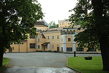
The Old Castle in Chodová Planá from 1734 was rebuilt into the cultural house. The New Castle was built in 1906. It includes a spacious park.[3]
In the brewery, there is a small brewery museum.
Notable people
[edit]- Johann Emanuel Veith (1787–1876), Roman Catholic preacher
Twin towns – sister cities
[edit]Chodová Planá is twinned with:[9]
 Störnstein, Germany
References
[edit]- ^ "Population of Municipalities – 1 January 2024". Czech Statistical Office. 2024-05-17.
- ^ "Rybník Regent u Chodové Plané" (in Czech). CzechTourism. Retrieved 2022-09-20.
- ^ a b c d e f "Historie" (in Czech). Městys Chodová Planá. Retrieved 2022-09-20.
- ^ "Historický lexikon obcí České republiky 1869–2011" (in Czech). Czech Statistical Office. 2015-12-21.
- ^ "Population Census 2021: Population by sex". Public Database. Czech Statistical Office. 2021-03-27.
- ^ "Pivovar Chodovar, Chodová Planá" (in Czech). Turistů ráj. Retrieved 2021-06-14.
- ^ "Pravé pivní lázně" (in Czech). Pivovar Chodovar. Retrieved 2021-06-14.
- ^ "Detail stanice Chodová Planá" (in Czech). České dráhy. Retrieved 2024-07-08.
- ^ "Partnerské město" (in Czech). Městys Chodová Planá. Retrieved 2021-06-14.
External links
[edit]Text is available under the CC BY-SA 4.0 license; additional terms may apply.
Images, videos and audio are available under their respective licenses.


