Banda Deul
| Banda Deul | |
|---|---|
 | |
| Religion | |
| Affiliation | Jainism/Hinduism |
| Location | |
| Location | Banda Purulia district |
| State | West Bengal |
| Country | India |
 Shown within West Bengal  Banda Deul (India) | |
| Geographic coordinates | 23°36′27″N 86°33′31″E / 23.6074°N 86.5587°E |
| Architecture | |
| Completed | 11th century |
Banda Deul is an 11th-century temple in Banda village (also called Deulghera) in the Raghunathpur II CD block in the Raghunathpur subdivision of the Purulia district in the Indian state of West Bengal.[1]
Geography
[edit]
5miles
Reservoir
Hill
M: municipal town, CT: census town, R: rural/ urban centre, H: historical/ religious centre, T: tourist centre
Owing to space constraints in the small map, the actual locations in a larger map may vary slightly
Location
[edit]Banda is located at 23°36′27″N 86°33′31″E / 23.6074°N 86.5587°E.
Banda is 1 km from Cheliyama, which contains the Radha Vinod temple with the most richly decorated terracotta carvings.[2]
Note: The map alongside presents some of the notable locations in the subdivision. All places marked in the map are linked in the larger full screen map.
Banda Deul
[edit]There is a temple at Banda, which is described by the Archaeological Survey of India as a rekha deul of triratha variety in sandstone.[3] The temple is richly decorated, the themes being creepers, scroll work and stylised chaitya window.[3]The temple is datable to c. 11th century AD.[3]
In 1872, the archaeologist J.D.Beglar came across this temple, then covered with deep vegetation in a forest. The area around the deul was cleared and it started attracting attention. It is not clear whether it was a Hindu or a Jain temple. The ground plan is star shpaed.[3] Internally the cella is square with a rectangular Mukhamandapa.[3] The temple consists of a single cell and it once had a mandapa.[4]
The temple had a mandapa which has largely collapsed, However, eight pillars are still there supporting the cross beams. The temple has a water outlet with a makara (crocodile) head.[2]
According to the List of Monuments of National Importance in West Bengal the old temple at Banda is an ASI listed monument.[1]
Banda picture gallery
[edit]-
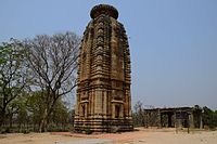 The deul at Banda with remains of the mandapa
 -
 The deul at Banda
 -
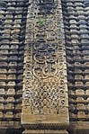 Stone decoration
 -
 Crocodile head shaped water outlet
 -
 Sculpture on the wall of temple of Banda
 -
 Mandapa in front of the temple of Banda


References
[edit]- ^ a b "List of Ancient Monuments and Archaeological Sites and Remains of West Bengal - Archaeological Survey of India". Item no. 134. ASI. Retrieved 25 January 2020.
- ^ a b "District Census Handbook, Puruliya, Series 20, Part XII A" (PDF). Banda - Page 101: Brief Description of Places of Religious, Historical or Archaeological Importance and Places of Tourist Importance of the District. Directorate of Census Operations, West Bengal. Retrieved 23 January 2020.
- ^ a b c d e "Old temple at Banda (locally known as deul)". ASI, Kolkata Circle. Retrieved 23 January 2020.
- ^ "Report of a Tour through the Bengal Provinces".
External links
[edit]Purulia district topics | |||||||||
|---|---|---|---|---|---|---|---|---|---|
| General | |||||||||
| Subdivisions | |||||||||
| Municipalities | |||||||||
| Community development blocks |
| ||||||||
| Education | |||||||||
| Hills | |||||||||
| Rivers | |||||||||
| Transport | |||||||||
| Railway stations | |||||||||
| Lok Sabha constituencies | |||||||||
| Vidhan Sabha constituencies | |||||||||
| Former Vidhan Sabha constituencies | |||||||||
| See also | |||||||||
Jain centres in West Bengal | |
|---|---|
| Historical centres | |
| Presently active centres | |
| See also | |

Text is available under the CC BY-SA 4.0 license; additional terms may apply.
Images, videos and audio are available under their respective licenses.
