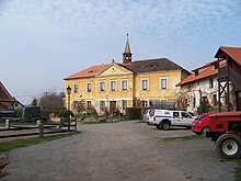
Čerčany
Čerčany | |
|---|---|
 Main road | |
| Coordinates: 49°51′11″N 14°42′11″E / 49.85306°N 14.70306°E | |
| Country | |
| Region | Central Bohemian |
| District | Benešov |
| First mentioned | 1356 |
| Area | |
| • Total | 6.45 km2 (2.49 sq mi) |
| Elevation | 285 m (935 ft) |
| Population (2024-01-01)[1] | |
| • Total | 3,134 |
| • Density | 490/km2 (1,300/sq mi) |
| Time zone | UTC+1 (CET) |
| • Summer (DST) | UTC+2 (CEST) |
| Postal code | 257 22 |
| Website | www |
Čerčany is a municipality and village in Benešov District in the Central Bohemian Region in the Czech Republic. It has about 3,100 inhabitants.
Administrative parts
[edit]The village of Vysoká Lhota is an administrative part of Čerčany.
Etymology
[edit]The original name of the settlement was Črnčany and was derived from the personal name Črnek or Črnec. The personal name itself was derived from černý (i.e. 'black').[2]
Geography
[edit]Čerčany is located about 7 kilometres (4 mi) north of Benešov and 24 km (15 mi) southeast of Prague. It lies in the Benešov Uplands. The highest point is the hill Čerčanský chlum at 530 m (1,740 ft) above sea level. The Sázava River flows through the municipality.
History
[edit]The first written mention of Čerčany is from 1356. The turning point was the construction of the railway from Prague to České Budějovice, which was completed in 1871, and Čerčany became a railway junction thanks to it. This contributed to the growth of the settlement, which at that time was part of Lštění. Čerčany has become a popular holiday resort. In 1919, Čerčany became an independent municipality.[3]
Demographics
[edit]
|
|
| ||||||||||||||||||||||||||||||||||||||||||||||||||||||
| Source: Censuses[4][5] | ||||||||||||||||||||||||||||||||||||||||||||||||||||||||
Transport
[edit]The I/3 road, which is part of the European route E55, passes through Čerčany.
Čerčany is located on the railway line Prague–Benešov. It is also the starting point of the railway line to Ledeč nad Sázavou.[6]
Sights
[edit]
In Vysoká Lhota is the Vysoká Lhota Castle. It was first documented in 1550. Baroque reconstruction took place in the 1740s.[7] Today there is a museum of carriages and wagons, and an exhibition about the history of the castle.[8]
Notable people
[edit]- Vlastimil Horváth (born 1977), singer
References
[edit]- ^ "Population of Municipalities – 1 January 2024". Czech Statistical Office. 2024-05-17.
- ^ Profous, Antonín (1947). Místní jména v Čechách I: A–H (in Czech). pp. 316–317.
- ^ "Historie" (in Czech). Obec Čerčany. Retrieved 2023-02-12.
- ^ "Historický lexikon obcí České republiky 1869–2011" (in Czech). Czech Statistical Office. 2015-12-21.
- ^ "Population Census 2021: Population by sex". Public Database. Czech Statistical Office. 2021-03-27.
- ^ "Detail stanice Čerčany" (in Czech). České dráhy. Retrieved 2024-06-04.
- ^ "Zámek" (in Czech). National Heritage Institute. Retrieved 2023-02-12.
- ^ "Muzeum a zámeček" (in Czech). Equi Hanuš. Retrieved 2023-02-12.
External links
[edit]Text is available under the CC BY-SA 4.0 license; additional terms may apply.
Images, videos and audio are available under their respective licenses.


