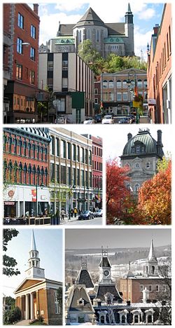
Σερμπρούκ
| Σερμπρούκ | ||
|---|---|---|
 | ||
| ||
| 45°24′0″N 71°54′0″W | ||
| Χώρα | Καναδάς[1] | |
| Διοικητική υπαγωγή | Εστρί | |
| Ίδρυση | 1793 | |
| Διοίκηση | ||
| • Δήμαρχος | Στιβ Λυσιέ (2017–2021)[2] | |
| Έκταση | 367,1 km² | |
| Πληθυσμός | 175.114 (1 Ιουλίου 2022)[3] | |
| Τηλ. κωδ. | 819[4] και 873[5][6][4] | |
| Ζώνη ώρας | ανατολική ζώνη ώρας UTC−5 (επίσημη ώρα) UTC-4 (θερινή ώρα) | |
| Ιστότοπος | Επίσημος ιστότοπος | |
Το Σερμπρούκ (αγγλικά και γαλλικά: Sherbrooke) είναι πόλη στο νότιο Κεμπέκ του Καναδά, η οποία βρίσκεται στη συμβολή των ποταμών Σαιντ-Φρανσουά και Μαγκόγκ στην καρδιά της διοικητικής περιοχής Εστρί.[7] Με 161.323 κατοίκους στην απογραφή του 2016,[8] αποτελεί την έκτη μεγαλύτερη πόλη στην επαρχία και την τριακοστή μεγαλύτερη στον Καναδά. Η Μητροπολιτική Περιοχή Απογραφής του Σερμπρούκ έχει 212.105 κατοίκους,[9] καθιστώντας την την τέταρτη μεγαλύτερη μητροπολιτική περιοχή στο Κεμπέκ και τη δέκατη ένατη μεγαλύτερη στον Καναδά.
Η πόλη αρχικώς ήταν γνωστή ως Χάιατς Μιλ (Hyatt's Mill), όμως μετονομάστηκε από τον Σερ Τζον Κόουπ Σερμπρούκ (1764-1840), Βρετανό στρατηγό, ο οποίος ήταν υπολοχαγός κυβερνήτης της Νέας Σκωτίας (1812-1816), και γενικός κυβερνήτης της Βρετανικής Βόρειας Αμερικής (1816-1818).
Παραπομπές
[Επεξεργασία | επεξεργασία κώδικα]- ↑ (Γερμανικά, Αγγλικά, Γαλλικά, Ισπανικά, Ιταλικά) archINFORM. 8621. Ανακτήθηκε στις 6 Αυγούστου 2018.
- ↑ Canada 2016 Census.
- ↑ www
.donneesquebec . Ανακτήθηκε στις 10 Δεκεμβρίου 2023..ca /recherche /fr /dataset /repertoire-des-municipalites-du-quebec /resource /c27b1830-2b46-4e80-819b-6238ff7c3b03 - ↑ 4,0 4,1 www
.cnac . Ανακτήθηκε στις 1 Μαΐου 2019..ca /area _code _maps /canadian _area _codes .htm #SouthernQuebec - ↑ soutien
.videotron . Ανακτήθηκε στις 1 Μαΐου 2019..com /residentiel /telephonie /nouvel-indicatif-telephonique-regional-873 - ↑ www
.newswire . Ανακτήθηκε στις 1 Μαΐου 2019..ca /news-releases /additional-area-code-873-now-available-for-new-telephone-numbers-in-the-819-region-in-quebec-510767361 .html - ↑ http://ftp.geogratis.gc.ca/pub/nrcan_rncan/raster/atlas_6_ed/reference/bilingual/que.pdf
- ↑ «Census Profile – Sherbrooke, Ville». Canada 2011 Census. Statistics Canada. 8 Φεβρουαρίου 2012. Ανακτήθηκε στις 9 Φεβρουαρίου 2012.
- ↑ Canada, Government of Canada, Statistics. «Census Profile, 2016 Census - Sherbrooke [Census metropolitan area], Quebec and Sherbrooke, Ville [Census subdivision], Quebec». www12.statcan.gc.ca (στα Αγγλικά). Ανακτήθηκε στις 20 Σεπτεμβρίου 2017.
|
Text is available under the CC BY-SA 4.0 license; additional terms may apply.
Images, videos and audio are available under their respective licenses.


