Αρχείο:USATopographicalMap.jpg
Μέγεθος αυτής της προεπισκόπησης: 800 × 527 εικονοστοιχεία . Άλλες αναλύσεις: 320 × 211 εικονοστοιχεία | 640 × 422 εικονοστοιχεία | 1.024 × 674 εικονοστοιχεία | 1.280 × 843 εικονοστοιχεία | 2.560 × 1.686 εικονοστοιχεία | 3.199 × 2.107 εικονοστοιχεία.
Εικόνα σε υψηλότερη ανάλυση (3.199 × 2.107 εικονοστοιχεία, μέγεθος αρχείου: 11,19 MB, τύπος MIME: image/jpeg)
|
|
Αυτό το αρχείο και η περιγραφή του προέρχονται από το Wikimedia Commons. Οι πληροφορίες από την σελίδα περιγραφής του εκεί εμφανίζονται παρακάτω. |
Σύνοψη
| Περιγραφή |
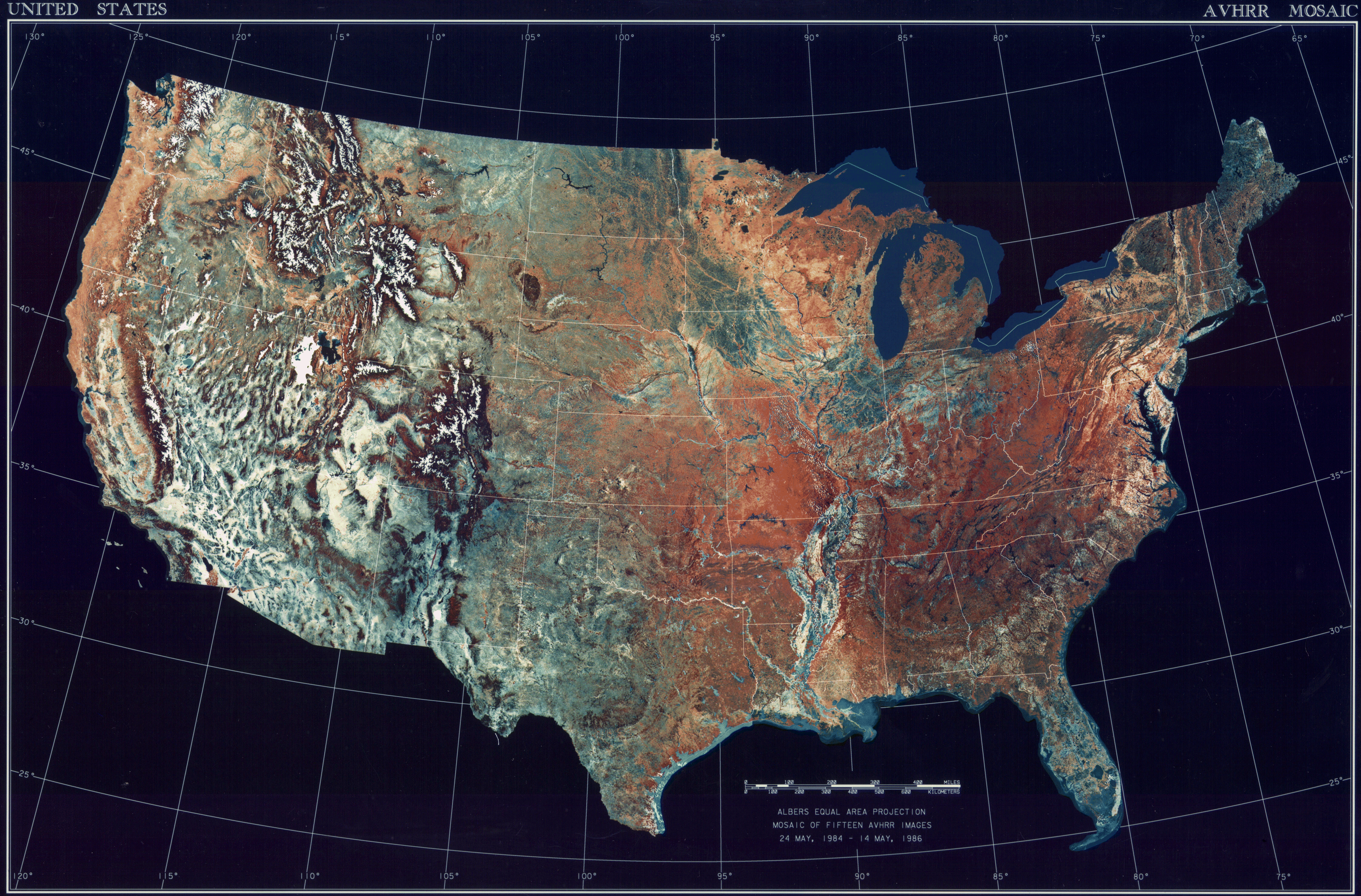
Deutsch: Satellitenbild der 48 Zentralstaaten der Vereinigten Staaten.
|
| Ημερομηνία | μεταξύ 24 Μαΐου 1984 και 14 Μαΐου 1986 |
| Πηγή | National Climactic Data Center/NOAA Satellite and Information Service |
| Δημιουργός | U.S. Dept. of Commerce/National Climactic Data Center/NOAA Satellite and Information Service |
Αδειοδότηση
This image is in the public domain because it contains materials that originally came from the U.S. National Oceanic and Atmospheric Administration, taken or made as part of an employee's official duties.
|
Ιστορικό αρχείου
Κλικάρετε σε μια ημερομηνία/ώρα για να δείτε το αρχείο όπως εμφανιζόταν εκείνη τη στιγμή.
| Ώρα/Ημερομ. | Μικρογραφία | Διαστάσεις | Χρήστης | Σχόλια | |
|---|---|---|---|---|---|
| τελευταία | 08:06, 25 Οκτωβρίου 2013 | | 3.199 × 2.107 (11,19 MB) | McZusatz | compression (uploaded using chunked upload script) |
| 17:33, 4 Μαρτίου 2009 |  | 3.199 × 2.107 (450 KB) | File Upload Bot (Magnus Manske) | ((BotMoveToCommons|en.wikipedia|year=((subst:CURRENTYEAR))|month=((subst:CURRENTMONTHNAME))|day=((subst:CURRENTDAY)))) ((Information |Description=((en|Topographical map of the United States)) |Source=Transferred from [http://en.wikipedia.org en.wikipedia |
Συνδέσεις αρχείου
Τα παρακάτω λήμματα συνδέουν σε αυτό το αρχείο:
Καθολική χρήση αρχείου
Τα ακόλουθα άλλα wiki χρησιμοποιούν αυτό το αρχείο:
- Χρήση σε ar.wikipedia.org
- Χρήση σε arz.wikipedia.org
- Χρήση σε ceb.wikipedia.org
- Χρήση σε de.wikipedia.org
- Χρήση σε dtp.wikipedia.org
- Χρήση σε en.wikipedia.org
- Χρήση σε es.wikipedia.org
- Χρήση σε fa.wikipedia.org
- Χρήση σε fr.wikipedia.org
- Χρήση σε fy.wikipedia.org
- Χρήση σε gu.wikipedia.org
- Χρήση σε he.wikipedia.org
- Χρήση σε ia.wikipedia.org
- Χρήση σε incubator.wikimedia.org
- Χρήση σε kn.wikipedia.org
- Χρήση σε la.wikipedia.org
- Χρήση σε lt.wikipedia.org
- Χρήση σε mnw.wikipedia.org
- Χρήση σε ms.wikipedia.org
- Χρήση σε my.wikipedia.org
- Χρήση σε pap.wikipedia.org
- Χρήση σε sq.wikipedia.org
- Χρήση σε sv.wikipedia.org
- Χρήση σε sw.wikipedia.org
- Χρήση σε ta.wikipedia.org
- Χρήση σε tcy.wikipedia.org
- Χρήση σε th.wikipedia.org
- Χρήση σε tl.wikipedia.org
- Χρήση σε uk.wikipedia.org
- Χρήση σε www.wikidata.org
- Χρήση σε yo.wikipedia.org
Text is available under the CC BY-SA 4.0 license; additional terms may apply.
Images, videos and audio are available under their respective licenses.
Cover photo is available under {{::mainImage.info.license.name || 'Unknown'}} license.
Cover photo is available under {{::mainImage.info.license.name || 'Unknown'}} license.
Credit:
(see original file).
