Αρχείο:France radar 2 dordogne.png
Δεν διατίθεται υψηλότερη ανάλυση.
France_radar_2_dordogne.png (657 × 292 εικονοστοιχεία, μέγεθος αρχείου: 343 KB, τύπος MIME: image/png)
| Αυτό το αρχείο και η περιγραφή του προέρχονται από το Wikimedia Commons. Οι πληροφορίες από την σελίδα περιγραφής του εκεί εμφανίζονται παρακάτω. |
Σύνοψη
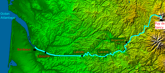
| Περιγραφή |
English: Map of Dordogne river made with France viewed by NASA Shuttle radar-imaging.
Français : Carte de la Dordogne faite à partir de l'image radar de la France vue depuis la navette spatiale, par la NASA. |
| Ημερομηνία | |
| Πηγή | Έργο αυτού που το ανεβάζει |
| Δημιουργός | Thierry46 |
Αδειοδότηση
- The purpose of NASA's Earth Observatory is to provide a freely-accessible publication on the Internet where the public can obtain new satellite imagery and scientific information about our home planet. The focus is on Earth's climate and environmental change. In particular, we hope our site is useful to public media and educators. Any and all materials published on the Earth Observatory are freely available for re-publication or re-use, except where copyright is indicated. We ask that NASA's Earth Observatory be given credit for its original materials.
This image uses high-resolution digital topography data from NASA's Shuttle Radar Topography Mission (SRTM) at JPL-Caltech [1]. It is in the public domain in the United States.
|
 | |
| This work was previously under Public Domain, or a Free License. It has been digitally enhanced and/or modified. This derivative work has been (or is hereby) released into the public domain by its author, Sting at the French Wikipedia project. This applies worldwide. In some countries this is not legally possible; if so:
|
Ιστορικό αρχείου
Κλικάρετε σε μια ημερομηνία/ώρα για να δείτε το αρχείο όπως εμφανιζόταν εκείνη τη στιγμή.
| Ώρα/Ημερομ. | Μικρογραφία | Διαστάσεις | Χρήστης | Σχόλια | |
|---|---|---|---|---|---|
| τελευταία | 19:40, 28 Αυγούστου 2008 | | 657 × 292 (343 KB) | Thierry46 | ((Information |Description=((en|1=Map of Dordogne river made with France viewed by NASA Shuttle radar-imaging. France radar 2.jpg)) ((fr|1=Carte de la rivière Dordogne faite à partir de l'image radar de la France vue depuis la navette spatiale, par |
Συνδέσεις αρχείου
Τα παρακάτω λήμματα συνδέουν σε αυτό το αρχείο:
Καθολική χρήση αρχείου
Τα ακόλουθα άλλα wiki χρησιμοποιούν αυτό το αρχείο:
- Χρήση σε bg.wikipedia.org
- Χρήση σε de.wikipedia.org
- Χρήση σε eo.wikipedia.org
- Χρήση σε fr.wikipedia.org
- Χρήση σε fr.wiktionary.org
- Χρήση σε ja.wikipedia.org
- Χρήση σε ro.wikipedia.org
- Χρήση σε sh.wikipedia.org
- Χρήση σε sr.wikipedia.org
Text is available under the CC BY-SA 4.0 license; additional terms may apply.
Images, videos and audio are available under their respective licenses.
Cover photo is available under {{::mainImage.info.license.name || 'Unknown'}} license.
Cover photo is available under {{::mainImage.info.license.name || 'Unknown'}} license.
Credit:
(see original file).
