For faster navigation, this Iframe is preloading the Wikiwand page for Αρχείο:Europe 1812 map en.png.

Αρχείο:Europe 1812 map en.png
Εικόνα σε υψηλότερη ανάλυση(2.284 × 1.503 εικονοστοιχεία, μέγεθος αρχείου: 1,14 MB, τύπος MIME: image/png)

Σύνοψη

This historical map image could be re-created using vector graphics as an SVG file. This has several advantages; see Commons:Media for cleanup for more information. If an SVG form of this image is available, please upload it and afterwards replace this template with ((vector version available|new image name)).
It is recommended to name the SVG file “Europe 1812 map en.svg”—then the template Vector version available (or Vva) does not need the new image name parameter.
Περιγραφή
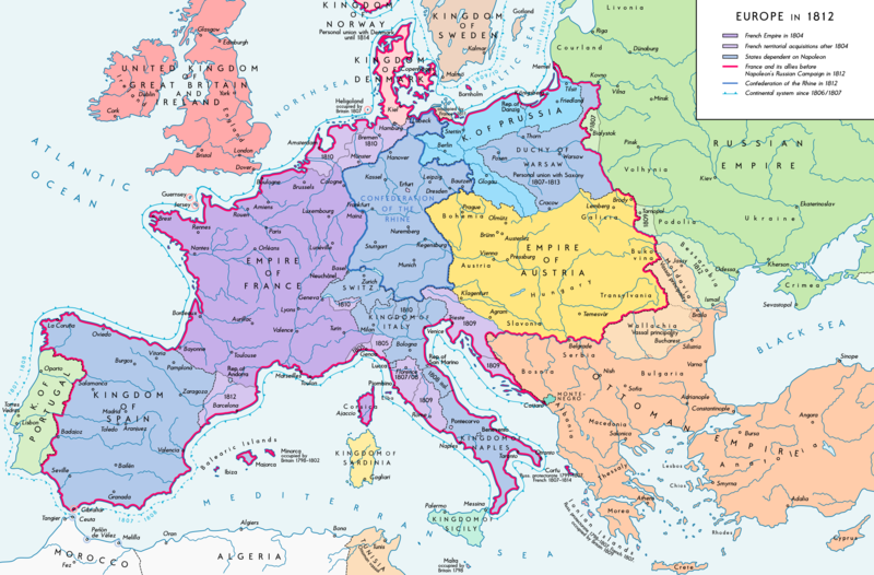
Deutsch: Europa 1812. Politische Ausgangslage vor Napeoleons Russlandfelzug.
English: Europe in 1812. Political situation before Napoleon's Russian Campaign.
Ημερομηνία
Πηγή Έργο αυτού που το ανεβάζει. Source of Information:
– Map "L'apogée de l'Empire Français (avant la campagne de Russie)" (Author unknown)(Link)
– Dr. Walter Leiserung (ed.): Historischer Weltatlas, Marix Verlag, Wiesbaden 2004, ISBN 978-3-937715-59-9
– Zentralinstitut für Geschichte der Akademie der Wissenschaften der DDR (ed.): Atlas zur Geschichte, Band 1, VEB Hermann Haack, Gotha 1989, ISBN 3-7301-0040-8
– Prof. Dr. Vadim Oswalt, Prof. Dr. Hans Ulrich Rudolf (ed.): Klett-Perthes Atlas zur Weltgeschichte, Ernst Klett Verlag, Stuttgart 2011, ISBN 978-3-12-828194-0
– Ferenc Majoros u. Bernd Rill: Das Osmanische Reich 1300-1922. Die Geschichte einer Großmacht, Lzenzausgabe für Weltbild Verlag, Augsburg 2000, ISBN 3-8289-0336-3
Δημιουργός Alexander Altenhof
άλλες εκδόσεις
Maps of the history of Europe
BCE
aC

Weichselian ice age (c. 113,000–9700) · Neolithic expansion (c. 7000–4500) · Middle Neolithic (c. 4500–4000) · Late Neolithic (c. 4000–3000) · Copper Age – Corded Ware culture (c. 2900–2350) · Copper Age – Bellbeaker culture (c. 2800–1800) · Early Bronze Age – Unetice culture (c. 2300–1600) · Late Bronze Age – Urnfield culture (c. 1300—750) · Migrations (c. 1000–100) · Hallstatt & La Tène cultures (c. 800–100) · Roman Republic (510–40) · 220 · 218 · 200 · 201–100 · 58 · 49 · 39 · 30 BCE–6 CE


CE
dC

14 · 14–37 · 60 · 60 · 69 · 80 · Migrations 100–500 · 117 · 117 · 125 · Migrations 150–774 · Economy 180 · 271 · 293–305 · 337 · 395 · c. 395 · 400 · 400 · 450 · 457–61 · 476 · 480 · Franks 481–814 · Early Slavs 500–700 · 500 · 526 · 526–600 · Christianisation to 600 · c. 550 · 650 · Pontic Steppe 650 · 665 · 800 · Vikings 800–1050 · 814 · 843–70 · 850 · 900 · 912 · 998 · 1000 · 1000 · 1054 · 1092 · First Crusade 1095–99 · 1097 · 1135 · 1142 · 1147–49 · 1190 · 1190 · 1250 · c. 1250 · 1301-1400 · 1301-1400 · 1328 · 1345 · Black Plague 1347–51 · 1360 · 1400 · Trade routes c. 1400 · 1430 · 1470 · 1490 · 1492 · 1500 · 1519 · 1550 · 1560 · Religion 1560 · Religion 1600 · Religion 1618 · 1618–48 · 1648 · 1683 · 1700 · 1701 · 1708 · 1714 · 1721 · 1725–30 · 1739–1740 · 1740 · 1748–66 · 1783–1792 · 1787 · 1787 · 1789 · 1799 · 1812 · 1812 · 1812 · 1812 · 1813 · 1815 · 1815 · 1815 · 1818 · Ottoman Empire 1830–1923 · 1848–49 · 1861 · 1867 · 1871 · 1878 · 1890 · 1905 · 1911 · 1914 · 1914 · 1919 · 1919–29 · 1923 · 1929 · 1930 · 1940 · 1941–42 · 1942–45 · Cold War 1947–91 · 1950 · 1993–2006 · 2006 to date

(this template: · view · discuss )

Αδειοδότηση

Εγώ, ο κάτοχος των πνευματικών δικαιωμάτων αυτού του έργου, το δημοσιεύω δια του παρόντος υπό την εξής άδεια χρήσης:
w:el:Creative Commons
αναφορά προέλευσης παρόμοια διανομή
Είστε ελεύθερος:
  • να μοιραστείτε – να αντιγράψετε, διανέμετε και να μεταδώσετε το έργο
  • να διασκευάσετε – να τροποποιήσετε το έργο
Υπό τις ακόλουθες προϋποθέσεις:
  • αναφορά προέλευσης – Θα πρέπει να κάνετε κατάλληλη αναφορά, να παρέχετε σύνδεσμο για την άδεια και να επισημάνετε εάν έγιναν αλλαγές. Μπορείτε να το κάνετε με οποιοδήποτε αιτιολογήσιμο λόγο, χωρίς όμως να εννοείται με οποιονδήποτε τρόπο ότι εγκρίνουν εσάς ή τη χρήση του έργου από εσάς.
  • παρόμοια διανομή – Εάν αλλάξετε, τροποποιήσετε ή δημιουργήσετε πάνω στο έργο αυτό, μπορείτε να διανείμετε αυτό που θα προκύψει μόνο υπό τους όρους της ίδιας ή συμβατής άδειας με το πρωτότυπο.

Λεζάντες

Δεν ορίστηκε λεζάντα
The Political situation of Europe in 1812, before the Russian campaign

Items portrayed in this file

απεικονίζει

Ιστορικό αρχείου

Κλικάρετε σε μια ημερομηνία/ώρα για να δείτε το αρχείο όπως εμφανιζόταν εκείνη τη στιγμή.

Ώρα/Ημερομ.ΜικρογραφίαΔιαστάσειςΧρήστηςΣχόλια
τελευταία15:26, 11 Σεπτεμβρίου 2016Μικρογραφία για την έκδοση της 15:26, 11 Σεπτεμβρίου 20162.284 × 1.503 (1,14 MB)KaterBegemotBorder corrections at Thorn and Tarnopol area, minor kerning and positioning changes
00:47, 20 Ιουλίου 2016Μικρογραφία για την έκδοση της 00:47, 20 Ιουλίου 20162.284 × 1.503 (1,14 MB)KaterBegemotAdded Bukovina / Corrected spelling of Sevastopol, Courland, Belgrade, Duchy of Warsaw / Marked Corfu as territory under French influence (red) / Correct position of city points of Basel, Geneva, Toulouse / Minor border corrections / Better kerning / T...
00:21, 14 Ιουλίου 2016Μικρογραφία για την έκδοση της 00:21, 14 Ιουλίου 20162.284 × 1.503 (1,14 MB)KaterBegemotAdded P. of Neuchatel, Ekaterinoslav, Varna, Brăila / Corrected borders of Montenegro, Milan-Genoa area
00:43, 3 Δεκεμβρίου 2015Μικρογραφία για την έκδοση της 00:43, 3 Δεκεμβρίου 20152.284 × 1.503 (1,09 MB)Ras67frame cropped
11:31, 29 Νοεμβρίου 2015Μικρογραφία για την έκδοση της 11:31, 29 Νοεμβρίου 20152.293 × 1.512 (1,12 MB)Spiridon Ion CepleanuSome details & corrections in the Austrian & Ottoman empires, according with « Grosser Atlas zur Weltgeschichte » (H.E.Stier, dir.) Westermann 1985, ISBN 3-14-100919-8, « Putzger historischer Weltatlas Cornelsen » 1990, ISBN 3-464-00176-8, « Atlas...
21:47, 5 Οκτωβρίου 2013Μικρογραφία για την έκδοση της 21:47, 5 Οκτωβρίου 20132.293 × 1.512 (1,01 MB)KaterBegemotCorrected boundaries of Switzerland, Prussia and Circassia
23:53, 15 Σεπτεμβρίου 2012Μικρογραφία για την έκδοση της 23:53, 15 Σεπτεμβρίου 20122.293 × 1.512 (1,01 MB)KaterBegemot== ((int:filedesc)) == ((Information |Description= ((de|1=Europa 1812. Politische Ausgangslage vor Napeoleons Russlandfelzug.))((en|1=Europe in 1812. Political situation before Napoleon's Russian Campaign.)) |Source=((Own)). Source of Information: </br...

Συνδέσεις αρχείου

Τα παρακάτω λήμματα συνδέουν σε αυτό το αρχείο:

Καθολική χρήση αρχείου

Τα ακόλουθα άλλα wiki χρησιμοποιούν αυτό το αρχείο:

Δείτε περισσότερη καθολική χρήση αυτού του αρχείου.

Μεταδεδομένα

{{bottomLinkPreText}} {{bottomLinkText}}
Αρχείο:Europe 1812 map en.png
Listen to this article

This browser is not supported by Wikiwand :(
Wikiwand requires a browser with modern capabilities in order to provide you with the best reading experience.
Please download and use one of the following browsers:

This article was just edited, click to reload
This article has been deleted on Wikipedia (Why?)

Back to homepage

Please click Add in the dialog above
Please click Allow in the top-left corner,
then click Install Now in the dialog
Please click Open in the download dialog,
then click Install
Please click the "Downloads" icon in the Safari toolbar, open the first download in the list,
then click Install
{{::$root.activation.text}}

Install Wikiwand

Install on Chrome Install on Firefox
Don't forget to rate us

Tell your friends about Wikiwand!

Gmail Facebook Twitter Link

Enjoying Wikiwand?

Tell your friends and spread the love:
Share on Gmail Share on Facebook Share on Twitter Share on Buffer

Our magic isn't perfect

You can help our automatic cover photo selection by reporting an unsuitable photo.

This photo is visually disturbing This photo is not a good choice

Thank you for helping!


Your input will affect cover photo selection, along with input from other users.

X

Get ready for Wikiwand 2.0 🎉! the new version arrives on September 1st! Don't want to wait?