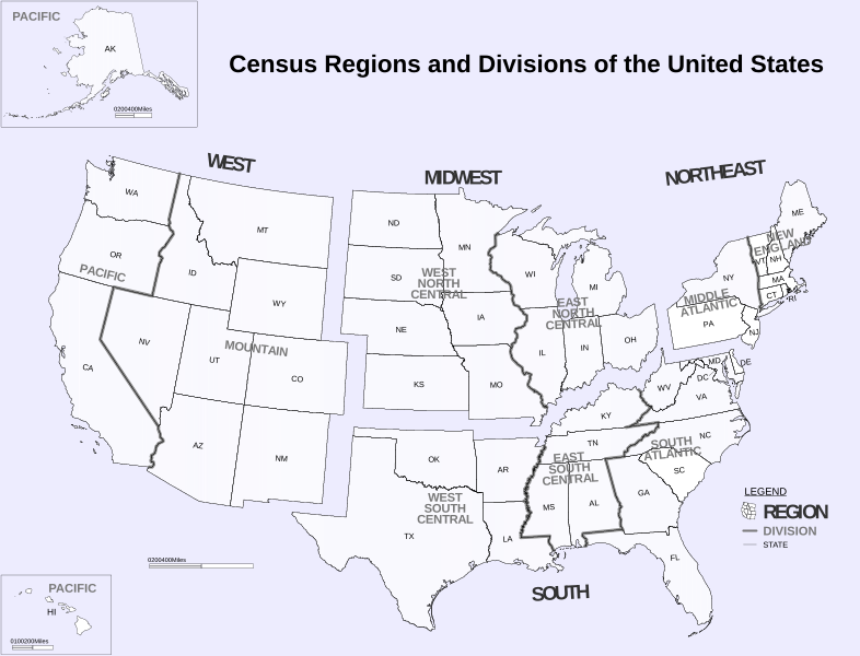
Αρχείο:Census Regions and Division of the United States.svg

Εικόνα σε υψηλότερη ανάλυση (Αρχείο SVG, ονομαστικό μέγεθος 942 × 719 εικονοστοιχεία, μέγεθος αρχείου: 1,27 MB)
Ιστορικό αρχείου
Κλικάρετε σε μια ημερομηνία/ώρα για να δείτε το αρχείο όπως εμφανιζόταν εκείνη τη στιγμή.
| Ώρα/Ημερομ. | Μικρογραφία | Διαστάσεις | Χρήστης | Σχόλια | |
|---|---|---|---|---|---|
| τελευταία | 06:02, 6 Νοεμβρίου 2018 |  | 942 × 719 (1,27 MB) | JoKalliauer | phab:35245 multiple xkoordinates |
| 23:10, 5 Νοεμβρίου 2018 |  | 942 × 719 (1,27 MB) | JoKalliauer | real text again | |
| 10:53, 26 Οκτωβρίου 2016 |  | 942 × 719 (2,07 MB) | Begoon | fix text | |
| 13:40, 8 Μαΐου 2011 |  | 942 × 719 (3,49 MB) | Ras67 | frame and watermark removed | |
| 18:14, 20 Ιουνίου 2010 |  | 942 × 719 (3,84 MB) | Smallman12q | ((Information |Description=((en|1=Census Regions and Division of the United States. ((Inkscape)))) |Source=http://www.census.gov/geo/www/us_regdiv.pdf |Author=US Census Bureau |Date=9-7-2000 (from pdf) |Permission=((PD-USGov-DOC-Census)) |other_versions=[ |
Συνδέσεις αρχείου
Τα παρακάτω λήμματα συνδέουν σε αυτό το αρχείο:
Καθολική χρήση αρχείου
Τα ακόλουθα άλλα wiki χρησιμοποιούν αυτό το αρχείο:
- Χρήση σε ar.wikipedia.org
- Χρήση σε ast.wikipedia.org
- Χρήση σε az.wikipedia.org
- Χρήση σε cs.wikipedia.org
- Χρήση σε da.wikipedia.org
- Χρήση σε de.wikipedia.org
- Χρήση σε en.wikipedia.org
- United States Census Bureau
- Mid-Atlantic (United States)
- List of regions of the United States
- Culture of the United States
- Category:Census regions of the United States
- Portal:U.S. roads/Selected picture/Regional balance
- Portal:U.S. roads/Selected article/Regional balance
- Portal:U.S. roads/Did you know/Regional balance
- User:SecretName101/Locations of major party United States presidential nominating conventions
- Χρήση σε eo.wikipedia.org
- Χρήση σε es.wikipedia.org
- Χρήση σε fa.wikipedia.org
- Χρήση σε fr.wikipedia.org
- Χρήση σε he.wikipedia.org
- Χρήση σε hy.wikipedia.org
- Χρήση σε ia.wikipedia.org
- Χρήση σε it.wikipedia.org
- Χρήση σε ja.wikipedia.org
- Χρήση σε nl.wikipedia.org
- Χρήση σε pt.wikipedia.org
- Χρήση σε ro.wikipedia.org
- Χρήση σε ru.wikipedia.org
- Χρήση σε ru.wikinews.org
- Χρήση σε sl.wikipedia.org
- Χρήση σε ta.wikipedia.org
- Χρήση σε tr.wikipedia.org
- Χρήση σε ur.wikipedia.org
- Χρήση σε www.wikidata.org
Μεταδεδομένα
Text is available under the CC BY-SA 4.0 license; additional terms may apply.
Images, videos and audio are available under their respective licenses.

