Viella (Gers)
aus Wikipedia, der freien Enzyklopädie
| Viella Vièla | ||
|---|---|---|
.svg)
|
| |
| Staat | Frankreich | |
| Region | Okzitanien | |
| Département (Nr.) | Gers (32) | |
| Arrondissement | Mirande | |
| Kanton | Adour-Gersoise | |
| Gemeindeverband | Armagnac Adour | |
| Koordinaten | 43° 36′ N, 0° 8′ W | |
| Höhe | 109–250 m | |
| Fläche | 22,02 km² | |
| Einwohner | 516 (1. Januar 2021) | |
| Bevölkerungsdichte | 23 Einw./km² | |
| Postleitzahl | 32400 | |
| INSEE-Code | 32463 | |
 Landschaft mit Weinberg in Viella | ||

Viella (gaskognisch: Vièla) ist eine französische Gemeinde mit 516 Einwohnern (Stand 1. Januar 2021) im Département Gers in der Region Okzitanien; sie gehört zum Arrondissement Mirande.
Geografie
[Bearbeiten | Quelltext bearbeiten]Viella liegt rund 15 Kilometer südöstlich der Kleinstadt Aire-sur-l’Adour im Westen des Départements Gers an der Grenze zu den Départements Hautes-Pyrénées und Pyrénées-Atlantiques. Die wichtigsten Gewässer sind die Flüsse Larcis und Saget, etliche Bäche sowie einige Staubecken und kleine Teiche. Wichtigste überregionale Verkehrsverbindung ist die wenige Kilometer westlich der Gemeinde verlaufende Autoroute A65 (Teil der Europastraße 7). Im nahen Riscle befindet sich die nächstgelegene Bushaltestelle (Buslinie 940 Aire-sur-l’Adour - Tarbes).
Umgeben wird Viella von den Nachbargemeinden Labarthète und Saint-Mont im Norden, Riscle im Nordosten, Maumusson-Laguian im Osten, Saint-Lanne (im Département Hautes-Pyrénées) im Südosten, Aydie und Aubous (beide im Département Pyrénées-Atlantiques) im Süden, Portet (im Département Pyrénées-Atlantiques) im Südwesten, Verlus im Westen sowie Aurensan im Nordwesten.
Geschichte
[Bearbeiten | Quelltext bearbeiten]Die Gemeinde lag in der Gascogne und gehörte dort zur Region Bas-Armagnac. Von 1793 bis 1801 gehörte Viella zum Distrikt Nogaro, von 1793–1801 und ab 1802 bis 2015 zum Wahlkreis (Kanton) Riscle (1801–1802 zum Kanton Barcelonne).
Bevölkerungsentwicklung
[Bearbeiten | Quelltext bearbeiten]| Jahr | 1962 | 1968 | 1975 | 1982 | 1990 | 1999 | 2006 | 2012 | 2020 |
| Einwohner | 705 | 674 | 595 | 626 | 580 | 560 | 538 | 534 | 509 |
| Quellen: Cassini und INSEE | |||||||||
Sehenswürdigkeiten
[Bearbeiten | Quelltext bearbeiten]- Kirche Saint-Pierre aus dem 18. Jahrhundert
- Schloss aus dem 18. Jahrhundert (früher im Besitz des Marquis de Viella)
- zahlreiche Flur- und Wegkreuze
-
 Schloss
 -
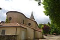 Kirche Saint-Pierre
 -
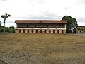
 Mairie (Rathaus)
 -
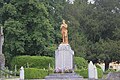 Denkmal für die Gefallenen
 -
 Boulodrome von Viella
 -
 Stierkampfarena


Weinbau
[Bearbeiten | Quelltext bearbeiten]Die Rebflächen in der Gemeinde sind Teil des Weinbaugebietes Béarn.
Weblinks
[Bearbeiten | Quelltext bearbeiten]Text is available under the CC BY-SA 4.0 license; additional terms may apply.
Images, videos and audio are available under their respective licenses.
