Valverde de Júcar
aus Wikipedia, der freien Enzyklopädie
| Gemeinde Valverde de Júcar | |||
|---|---|---|---|
 Valverde de Júcar | |||
| Wappen | Karte von Spanien | ||
.svg)
|
| ||
| Basisdaten | |||
| Land: | |||
| Autonome Gemeinschaft: | |||
| Provinz: | Cuenca | ||
| Comarca: | La Mancha de Cuenca | ||
| Gerichtsbezirk: | Cuenca | ||
| Koordinaten: | 39° 43′ N, 2° 13′ W | ||
| Höhe: | 828 msnm | ||
| Fläche: | 56,21 km² | ||
| Einwohner: | 1.091 (1. Jan. 2022)[1] | ||
| Bevölkerungsdichte: | 19 Einw./km² | ||
| Postleitzahl(en): | 16100 | ||
| Gemeindenummer (INE): | 16236 | ||
| Verwaltung | |||
| Bürgermeisterin: | Juliana Paula Bautista Alarcón (PP) | ||
| Website: | Valverde de Júcar | ||
| Lage des Ortes | |||
Karte anzeigen  | |||

Valverde de Júcar ist eine Gemeinde (Municipio) und ein Dorf mit 1091 Einwohnern (Stand 1. Januar 2022) in der Provinz Cuenca in der Autonomen Region Kastilien-La Mancha.
Lage
[Bearbeiten | Quelltext bearbeiten]Valverde de Júcar liegt etwa 55 Kilometer südsüdwestlich von Cuenca in einer Höhe von ca. 830 m. Der Júcar wird hier zur Embalse de Alarcón aufgestaut.
Bevölkerungsentwicklung
[Bearbeiten | Quelltext bearbeiten]| 1900 | 1950 | 1970 | 1981 | 1991 | 2001 | 2011 | 2021 |
|---|---|---|---|---|---|---|---|
| 1920 | 3177 | 1915 | 1603 | 1498 | 1326 | 1224 | 1108[2] |
Sehenswürdigkeiten
[Bearbeiten | Quelltext bearbeiten]- Magdalenenkirche
- Marienkapelle
- Christopheruskapelle
- Rathaus
-
 Magdalenenkirche
 -
 Marienkapelle
 -
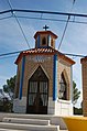 Christopheruskapelle
 -
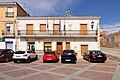 Rathaus


Weblinks
[Bearbeiten | Quelltext bearbeiten]Einzelnachweise
[Bearbeiten | Quelltext bearbeiten]- ↑ Cifras oficiales de población de los municipios españoles en aplicación de la Ley de Bases del Régimen Local (Art. 17). Instituto Nacional de Estadística (Bevölkerungsstatistiken des Instituto Nacional de Estadística, Stand 1. Januar 2022).
- ↑ Valverde de Júcar - Bevölkerungstabellen
Abia de la Obispalía | El Acebrón | Alarcón | Albaladejo del Cuende | Albalate de las Nogueras | Albendea | La Alberca de Záncara | Alcalá de la Vega | Alcantud | Alcázar del Rey | Alcohujate | Alconchel de la Estrella | Algarra | Aliaguilla | La Almarcha | Almendros | Almodóvar del Pinar | Almonacid del Marquesado | Altarejos | Arandilla del Arroyo | Arcas | Arcos de la Sierra | Arguisuelas | Arrancacepas | Atalaya del Cañavate | Barajas de Melo | Barchín del Hoyo | Bascuñana de San Pedro | Beamud | Belinchón | Belmonte | Belmontejo | Beteta | Boniches | Buciegas | Buenache de Alarcón | Buenache de la Sierra | Buendía | Campillo de Altobuey | Campillos-Paravientos | Campillos-Sierra | Campos del Paraíso | Canalejas del Arroyo | Cañada del Hoyo | Cañada Juncosa | Cañamares | El Cañavate | Cañaveras | Cañaveruelas | Cañete | Cañizares | Carboneras de Guadazaón | Cardenete | Carrascosa | Carrascosa de Haro | Casas de Benítez | Casas de Fernando Alonso | Casas de Garcimolina | Casas de Guijarro | Casas de Haro | Casas de los Pinos | Casasimarro | Castejón | Castillejo de Iniesta | Castillejo-Sierra | Castillo de Garcimuñoz | Castillo-Albaráñez | Cervera del Llano | La Cierva | Cuenca | Cueva del Hierro | Chillarón de Cuenca | Chumillas | Enguídanos | Fresneda de Altarejos | Fresneda de la Sierra | La Frontera | Fuente de Pedro Naharro | Fuentelespino de Haro | Fuentelespino de Moya | Fuentenava de Jábaga | Fuentes | Fuertescusa | Gabaldón | Garaballa | Gascueña | Graja de Campalbo | Graja de Iniesta | Henarejos | El Herrumblar | La Hinojosa | Los Hinojosos | El Hito | Honrubia | Hontanaya | Hontecillas | Horcajo de Santiago | Huélamo | Huelves | Huérguina | Huerta de la Obispalía | Huerta del Marquesado | Huete | Iniesta | Laguna del Marquesado | Lagunaseca | Landete | Ledaña | Leganiel | Las Majadas | Mariana | Masegosa | Las Mesas | Minglanilla | Mira | Monreal del Llano | Montalbanejo | Montalbo | Monteagudo de las Salinas | Mota de Altarejos | Mota del Cuervo | Motilla del Palancar | Moya | Narboneta | Olivares de Júcar | Olmeda de la Cuesta | Olmeda del Rey | Olmedilla de Alarcón | Olmedilla de Eliz | Osa de la Vega | Pajarón | Pajaroncillo | Palomares del Campo | Palomera | Paracuellos | Paredes | La Parra de las Vegas | El Pedernoso | Las Pedroñeras | El Peral | La Peraleja | La Pesquera | El Picazo | Pinarejo | Pineda de Gigüela | Piqueras del Castillo | Portalrubio de Guadamejud | Portilla | Poyatos | Pozoamargo | Pozorrubielos de la Mancha | Pozorrubio | El Pozuelo | Priego | El Provencio | Puebla de Almenara | Puebla del Salvador | Quintanar del Rey | Rada de Haro | Reíllo | Rozalén del Monte | Saceda-Trasierra | Saelices | Salinas del Manzano | Salmeroncillos | Salvacañete | San Clemente | San Lorenzo de la Parrilla | San Martín de Boniches | San Pedro Palmiches | Santa Cruz de Moya | Santa María de los Llanos | Santa María del Campo Rus | Santa María del Val | Sisante | Solera de Gabaldón | Sotorribas | Talayuelas | Tarancón | Tébar | Tejadillos | Tinajas | Torralba | Torrejoncillo del Rey | Torrubia del Campo | Torrubia del Castillo | Tragacete | Tresjuncos | Tribaldos | Uclés | Uña | Los Valdecolmenas | Valdemeca | Valdemorillo de la Sierra | Valdemoro-Sierra | Valdeolivas | Valdetórtola | Las Valeras | Valhermoso de la Fuente | El Valle de Altomira | Valsalobre | Valverde de Júcar | Valverdejo | Vara de Rey | Vega del Codorno | Vellisca | Villaconejos de Trabaque | Villaescusa de Haro | Villagarcía del Llano | Villalba de la Sierra | Villalba del Rey | Villalgordo del Marquesado | Villalpardo | Villamayor de Santiago | Villanueva de Guadamejud | Villanueva de la Jara | Villar de Cañas | Villar de Domingo García | Villar de la Encina | Villar de Olalla | Villar del Humo | Villar del Infantado | Villar y Velasco | Villarejo de Fuentes | Villarejo de la Peñuela | Villarejo-Periesteban | Villares del Saz | Villarrubio | Villarta | Villas de la Ventosa | Villaverde y Pasaconsol | Víllora | Vindel | Yémeda | Zafra de Záncara | Zafrilla | Zarza de Tajo | Zarzuela
Text is available under the CC BY-SA 4.0 license; additional terms may apply.
Images, videos and audio are available under their respective licenses.
