Distrikt Tanta
aus Wikipedia, der freien Enzyklopädie
| Distrikt Tanta | |
|---|---|
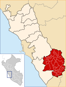
 Der Distrikt Tanta liegt im westlichen Norden der Provinz Yauyos (rot markiert) | |
| Basisdaten | |
| Staat | Peru |
| Region | Lima |
| Provinz | Yauyos |
| Sitz | Tanta |
| Fläche | 346 km² |
| Einwohner | 534 (2017) |
| Dichte | 1,5 Einwohner pro km² |
| Gründung | 2. Februar 1956 |
| ISO 3166-2 | PE-LIM |
| Politik | |
| Alcaldesa Distrital | Celestina Victoria Reyes Ysla (2019–2022) |
| Partei | Fuerza Popular |
 | |

Der Distrikt Tanta liegt in der Provinz Yauyos in der Region Lima im zentralen Westen von Peru. Der Distrikt wurde am 2. Februar 1956 gegründet. Er besitzt eine Fläche von 346 km². Beim Zensus 2017 wurden 534 Einwohner gezählt. Im Jahr 1993 lag die Einwohnerzahl bei 518, im Jahr 2007 bei 500. Sitz der Distriktverwaltung ist die 4278 m hoch gelegene Ortschaft Tanta mit 519 Einwohnern (Stand 2017). Tanta befindet sich 39 km nordnordwestlich der Provinzhauptstadt Yauyos. Der Distrikt befindet sich zum größten Teil innerhalb des Schutzgebietes Reserva Paisajística Nor Yauyos Cochas.
Geographische Lage
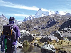
[Bearbeiten | Quelltext bearbeiten]Der Distrikt Tanta befindet sich in der peruanischen Westkordillere im westlichen Norden der Provinz Yauyos. Das Gebiet umfasst das Quellgebiet des Río Cañete. Dieser durchquert den aufgestauten See Laguna Paucarcocha. Im Süden des Distrikts befinden sich die Bergseen Laguna Ticllacocha, Laguna Piscococha und Laguna Chuspicocha. Im äußersten Süden liegt der Gipfel Nevado Ticlla (5897 m), im äußersten Nordwesten der Nevado Pariacaca (5758 m).
Der Distrikt Tanta grenzt im Südwesten an die Distrikte Quinches, Huañec und San Joaquín, im Westen an den Distrikt San Lorenzo de Quinti (Provinz Huarochirí), im Norden an den Distrikt Canchayllo (Provinz Jauja), im Osten an die Distrikte Huancaya, Vitis und Miraflores sowie im äußersten Süden an den Distrikt Ayaviri.
Weblinks
[Bearbeiten | Quelltext bearbeiten]- Peru: Region Lima (Provinzen und Bezirke) bei www.citypopulation.de
- INEI Perú
Text is available under the CC BY-SA 4.0 license; additional terms may apply.
Images, videos and audio are available under their respective licenses.
