Tambacounda (Département)
aus Wikipedia, der freien Enzyklopädie

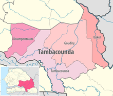
Das Département Tambacounda ist eines von 45 Départements, in die der Senegal, und eines von vier Départements, in die die Region Tambacounda gegliedert ist. Es liegt im Südosten des Senegal mit der Hauptstadt Tambacounda.
Das Département Tambacounda hatte bis 2008 eine Fläche von 20328 km².[1] In diesem Jahr wurde aus dem Westteil durch Ausgliederung ein neues Département mit der Präfektur Koumpentoum geschaffen, sodass sich das Département Tambacounda auf 13857 km² verkleinert hat.[2] Es gliedert sich wie folgt in Arrondissements, Kommunen (Communes) und Landgemeinden (Communautés rurales): [3][4][5]
| Commune / Arrondissement |
Communauté rurale |
Einwohner 2013 |
| Tambacounda | — | 107.293 |
| Koussanar | Koussanar | 26.362 |
| Koussanar | Sinthiou Malème | 20.002 |
| Makacolibantang | Makacolibantang | 37.572 |
| Makacolibantang | Ndoga Babacar | 20.153 |
| Makacolibantang | Niani Toucouleur | 10.974 |
| Missirah | Dialacoto | 16.450 |
| Missirah | Missirah | 41.659 |
| Missirah | Néttéboulou | 18.696 |
| Département | — | 299.163 |
Einzelnachweise
[Bearbeiten | Quelltext bearbeiten]- ↑ Service Régional de la Statistique et de la Démographie de Tambacounda: Situation economique et sociale regionale 2005 Fläche bis 2008: Seite 10 der PDF-Datei 0,37 MB
- ↑ Service Régional de la Statistique et de la Démographie de Tambacounda: Situation economique et sociale regionale 2014 Fläche seit 2008: Seite 27 der PDF-Datei 2,02 MB
- ↑ DECRET n° 2008-747 du 10 juillet 2008 portant création de départements et d’arrondissements ( vom 2. August 2018 im Internet Archive)
- ↑ Décret n° 2008-1025 du 10 septembre 2008 fixant le ressort territorial et le Chef-lieu des régions, départements et arrondissements ( vom 11. Januar 2019 im Internet Archive)
- ↑ Service Régional de la Statistique et de la Démographie de Tambacounda: Situation economique et sociale regionale 2013 ( vom 20. Oktober 2019 im Internet Archive) Einwohnerzahlen Seite 16 und 113 der PDF-Datei 1,10 MB
Koordinaten: 14° 50′ N, 12° 30′ W
Text is available under the CC BY-SA 4.0 license; additional terms may apply.
Images, videos and audio are available under their respective licenses.
