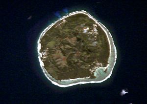
Rimatara
aus Wikipedia, der freien Enzyklopädie
| Rimatara | ||
|---|---|---|
 | ||
| Gewässer | Pazifischer Ozean | |
| Inselgruppe | Austral-Inseln | |
| Geographische Lage | 22° 39′ 5″ S, 152° 48′ 16″ W | |
|
| ||
| Fläche | 9 km² | |
| Höchste Erhebung | Mont Uahu 83 m | |
| Einwohner | 797 (2007) 89 Einw./km² | |
| Hauptort | Amaru | |
Rimatara ist die westlichste bewohnte Insel der Austral-Inseln und gehört zum Französischen Überseegebiet Französisch-Polynesien. Lediglich das unbewohnte Atoll Maria liegt noch weiter westlich.
Geografie
[Bearbeiten | Quelltext bearbeiten]Die Insel mit einem annähernd kreisförmigen Grundriss hat eine Landfläche von 8,6 km² und ist von einem Korallenriff umgeben. Die Fläche der Lagune misst zwei Quadratkilometer. Die Insel ist relativ flach: die höchste Erhebung, der Berg Uhau, ragt nur 106 Meter auf.[1] Rimatara ist fruchtbar und von Wald und Grasland bedeckt. Mit dem Rimatararohrsänger gibt es auf der Insel eine endemische Vogelart.
Die Bevölkerung im Jahr 2007 lag bei 797 Einwohnern, die in den drei Dörfern Amaru (im Osten), Anapoto (im Westen) und Mutuaura (im Süden) leben.
Der Flugplatz von Rimatara (IATA-Kennzeichen: RMT) befindet sich an der Nordseite der Insel. Air Tahiti fliegt unter anderem nach Tahiti.
Geschichte
[Bearbeiten | Quelltext bearbeiten]
Rimatara wurde erst im Jahr 1811 von dem auf Tahiti geborenen Kapitän Samuel Pinder Henry (* 8. Februar 1800; † 9. Juni 1852) entdeckt.[2] 1821 landete der Pfarrer William Henry hier an und gründete eine protestantische Missionsstation. Frankreich errichtete 1889 das Protektorat über die Insel und annektierte sie 1900.
Einzelnachweise
[Bearbeiten | Quelltext bearbeiten]- ↑ Bernard Salvat, Tamatoa Bambridge, Donatien Tanret, Jerôme Petit (eds.): Environnement Marin des Îles Australes. Polynésie Française, Tahiti 2015, S. 205
- ↑ Jaques-Antoine Moerenhout: Travels to the Islands of the Pacific Ocean. Lanham 1993, S. 459 (Übersetzung von Voyages aux îles du Grand Océan. Paris 1837) Nach Dunmore (Who's Who in Pacific Navigation) kann die Entdeckung jedoch nicht 1811 stattgefunden haben, da S. P. Henry zu diesem Zeitpunkt erst elf Jahre alt gewesen wäre. „This discovery was probably made during Henry's 1821 voyage.“ (ebd., S. 130)
Weblinks
[Bearbeiten | Quelltext bearbeiten]Text is available under the CC BY-SA 4.0 license; additional terms may apply.
Images, videos and audio are available under their respective licenses.

