Provinz Veraguas
aus Wikipedia, der freien Enzyklopädie
| Veraguas | |
|---|---|
 | |
| Daten | |
| Hauptstadt | Santiago de Veraguas |
| Einwohnerzahl | 259.791 |
| Fläche | 10.597,5 km² |
| Bevölkerungsdichte | 24,5 Ew./km² |
| Gliederung | 12 |
| Weitere Städte | El Tigre, Santa Fe |
| Flüsse | Rio Santa Maria, Rio San Pablo |
| ISO 3166-2 | PA-9 |
 | |
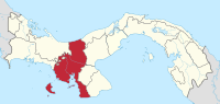
Veraguas ist die drittgrößte Provinz in Panama und grenzt als einzige sowohl an den Pazifik als auch an den Atlantik. Im Jahr 2023 hatte sie 259.791 Einwohner auf einer Fläche von 10.597,5 km².[1]
Die Hauptstadt von Veraguas ist Santiago de Veraguas im Osten der Provinz. Die Küstenlänge am Atlantik beträgt 43 Kilometer und am Pazifik 353 Kilometer. Zu Veraguas gehören rund 40 kleinere und größere Inseln, die größte darunter ist die Isla de Coiba im Golf von Chiriquí, die mit 493 km² die größte Insel Panamas ist.
Rund 4 % der Bevölkerung gehören der indigenen Bevölkerungsgruppe an. Die Hauptwirtschaftsfaktoren in Veraguas sind die Landwirtschaft (Reis, Mais, Zuckerrohr, Kaffee) und in den letzten Jahren im zunehmenden Ausmaß auch Tourismus (vor allem auf der Azuero-Halbinsel).
Die Provinz Veraguas ist ihrerseits wiederum in zwölf Bezirke (distritos) mit insgesamt 105 Gemeinden (corregimientos) unterteilt (in Klammern die jeweilige Bezirkshauptstadt):[1]
- Bezirk Atalaya (Atalaya)
- Bezirk Calobre (Calobre)
- Bezirk Cañazas (Cañazas)
- Bezirk La Mesa (La Mesa)
- Bezirk Las Palmas (Las Palmas)
- Bezirk Montijo (Montijo)
- Bezirk Río de Jesús (Río de Jesús)
- Bezirk San Francisco (San Francisco)
- Bezirk Santa Fe (Santa Fé)
- Bezirk Santiago (Santiago de Veraguas)
- Bezirk Soná (Soná)
- Bezirk Mariato (Mariato)
Siehe auch
[Bearbeiten | Quelltext bearbeiten]Weblinks
[Bearbeiten | Quelltext bearbeiten]Einzelnachweise
[Bearbeiten | Quelltext bearbeiten]- ↑ a b Superficie, población y densidad de población en la República, según provincia, comarca indígena, distrito y corregimiento: Censos de 2000, 2010 y 2023. (PDF) In: Instituto Nacional de Estadística y Censo – Panamá. Abgerufen am 23. Juli 2024.
Provinzen: Bocas del Toro | Chiriquí | Coclé | Colón | Darién | Herrera | Los Santos | Panamá | Panamá Oeste | Veraguas
Territorien: Emberá-Wounaan | Guna Yala | Naso Tjër Di | Ngöbe-Buglé – ohne Provinzstatus: Guna de Madugandí | Guna de Wargandí
Koordinaten: 8° 0′ N, 81° 12′ W
Text is available under the CC BY-SA 4.0 license; additional terms may apply.
Images, videos and audio are available under their respective licenses.
