Provinz Masvingo
aus Wikipedia, der freien Enzyklopädie
| Masvingo Provinz Masvingo
| |
|---|---|
 | |
| Basisdaten | |
| Staat | Simbabwe |
| Hauptstadt | Masvingo |
| Fläche | 56.456 km² |
| Einwohner | 1.638.528 (2022) |
| Dichte | 29 Einwohner pro km² |
| ISO 3166-2 | ZW-MV |

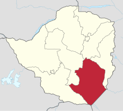
Masvingo ist eine Provinz im Südosten von Simbabwe. Sie umfasst ein Gebiet von 56.456 Quadratkilometern mit einer Bevölkerung von 1.638.528 Menschen (2022).[1] Sie ist nach ihrer Hauptstadt Masvingo benannt.
Geographie
[Bearbeiten | Quelltext bearbeiten]Die Provinz wird dominiert vom Karanga-Stamm, der zu den Shona zählt. Sie zählt zum semiariden Tiefland, was für die Rinderzucht günstige Bedingungen bietet. Außerhalb der Regenzeit ist das Gebiet staubig und trocken.
Im Wesentlichen finden sich offene Wälder mit Grasland und Granithügeln. Daneben gibt es etwas Bergbau und Zuckerrohranbau, der durch den Mukurikwi-Fluss bewässert wird. Im Osten grenzt die Provinz an Mosambik und im Süden an den Kruger-Nationalpark in Südafrika.
Entlang der Grenze zu Mosambik liegt der Gonarezhou-Nationalpark.
| Provinz Midlands | Provinz Mashonaland East | Provinz Manicaland |
| Provinz Midlands | .svg)
|
Provinz Manicaland |
| Provinz Matabeleland South | Provinz Limpopo, Südafrika | Provinz Gaza, Mosambik |
Distrikte
[Bearbeiten | Quelltext bearbeiten]
Masvingo besteht aus neun Distrikten (Stand 2022). Davon sind 7 Ländliche Distrikte (Rural) und 2 Städte mit Distrikt Status (Urban):[2]
| Distrikt | Fläche in [km²] | Einwohner 2012[3] | Einwohner 2022 | Bevölkerungsdichte 2022 [Einwohner/km²] |
|---|---|---|---|---|
| Bikita | 5180 | 162.356 | 176.835 | 34 |
| Chiredzi Rural | 17.401 | 275.759 | 303.503 | 17 |
| Chiredzi Urban | 22 | 30.448 | 40.457 | 1824 |
| Chivi | 3543 | 166.049 | 172.979 | 49 |
| Gutu | 7054 | 203.083 | 208.149 | 30 |
| Masvingo Rural | 6849 | 211.215 | 238.103 | 35 |
| Masvingo Urban | 72 | 87.886 | 90.286 | 1256 |
| Mwenezi | 13.210 | 166.993 | 209.327 | 16 |
| Zaka Rural | 3126 | 181.301 | 198.889 | 64 |
| Gesamt | 56.456 | 1.485.090 | 1.638.528 | 29 |
Weblinks
[Bearbeiten | Quelltext bearbeiten]Einzelnachweise
[Bearbeiten | Quelltext bearbeiten]Text is available under the CC BY-SA 4.0 license; additional terms may apply.
Images, videos and audio are available under their respective licenses.
