Poligné
aus Wikipedia, der freien Enzyklopädie
| Poligné | ||
|---|---|---|
| ||
| Staat | Frankreich | |
| Region | Bretagne | |
| Département (Nr.) | Ille-et-Vilaine (35) | |
| Arrondissement | Redon | |
| Kanton | Bain-de-Bretagne | |
| Gemeindeverband | Bretagne Porte de Loire Communauté | |
| Koordinaten | 47° 53′ N, 1° 41′ W | |
| Höhe | 12–93 m | |
| Fläche | 9,24 km² | |
| Einwohner | 1.228 (1. Januar 2021) | |
| Bevölkerungsdichte | 133 Einw./km² | |
| Postleitzahl | 35320 | |
| INSEE-Code | 35231 | |
 Die neue Mairie | ||

Poligné (auf Gallo Polinyae, auf Bretonisch Polinieg) ist eine Gemeinde im französischen Département Ille-et-Vilaine in der Bretagne. Sie gehört dort zum Kanton Bain-de-Bretagne im Arrondissement Redon. Sie grenzt im Norden an Bourg-des-Comptes, im Nordosten an Crevin, im Osten an Pancé und im Süden und im Westen an Pléchâtel. Das Siedlungsgebiet liegt durchschnittlich auf knapp 70 Metern über Meereshöhe.
Die Route nationale 137 führt über Poligné.
Sehenswürdigkeiten
[Bearbeiten | Quelltext bearbeiten]Siehe auch: Liste der Monuments historiques in Poligné
- Château du Bois-Glaume, Monument historique
- Kirche Saint-Donatien-Saint-Rogatien
- Kriegerdenkmal
-
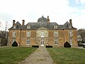 Château du Bois-Glaume
 -
 Die Kapelle des Schlosses Bois-Glaume
 -
 Kirche Saint-Donatien-Saint-Rogatien
 -
 Kriegerdenkmal


Bevölkerungsentwicklung
[Bearbeiten | Quelltext bearbeiten]| Jahr | 1962 | 1968 | 1975 | 1982 | 1990 | 1999 | 2008 | 2013 |
|---|---|---|---|---|---|---|---|---|
| Einwohner | 430 | 456 | 447 | 492 | 618 | 760 | 1099 | 1140 |
Literatur
[Bearbeiten | Quelltext bearbeiten]- Le Patrimoine des Communes d’Ille-et-Vilaine. Flohic Editions, Band 1, Paris 2000, ISBN 2-84234-072-8, S. 151–156.
Weblinks
[Bearbeiten | Quelltext bearbeiten]Commons: Poligné – Sammlung von Bildern, Videos und Audiodateien
Text is available under the CC BY-SA 4.0 license; additional terms may apply.
Images, videos and audio are available under their respective licenses.
Cover photo is available under {{::mainImage.info.license.name || 'Unknown'}} license.
Cover photo is available under {{::mainImage.info.license.name || 'Unknown'}} license.
Credit:
(see original file).
