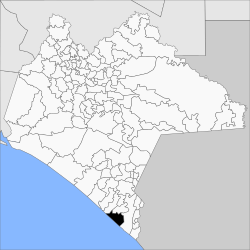
Municipio Mazatán (Chiapas)
aus Wikipedia, der freien Enzyklopädie
| Mazatán | ||
|---|---|---|

| ||
| Symbole | ||
| ||
| Basisdaten | ||
| Staat | Mexiko | |
| Bundesstaat | Chiapas | |
| Sitz | Mazatán | |
| Fläche | 384 km² | |
| Einwohner | 26.573 (2010) | |
| Dichte | 69,2 Einwohner pro km² | |
| Gründung | 1942 | |
| INEGI-Nr. | 07054 | |
| Politik | ||
| Presidente municipal | Gilberto Barrientos Coyotzi | |
Koordinaten: 14° 52′ N, 92° 27′ W
Mazatán ist ein Municipio im Südwesten des mexikanischen Bundesstaats Chiapas. Das Municipio hat 26.573 Einwohner und eine Fläche von 384 km². Verwaltungssitz und größter Ort des Municipios ist das gleichnamige Mazatán.
Der Name Mazatán kommt aus dem Nahuatl und bedeutet „Platz, wo es viel Wild gibt“. Das Municipio hat Anteil am Biosphärenreservat La Encrucijada.
Geographie
[Bearbeiten | Quelltext bearbeiten]Das Municipio Mazatán liegt im Süden des mexikanischen Bundesstaats Chiapas in der Region Soconusco auf Höhen unter 100 m. Es zählt zur Gänze zur physiographischen Provinz der Cordillera Centroamericana und liegt gänzlich in der hydrologischen Region Costa de Chiapas. Die Geologie des Municipios wird zu 66 % von Alluvionen bestimmt bei 19 % lakustrischen Ablagerungen; vorherrschende Bodentypen sind Phaeozem (65 %), Gleysol (16 %) und Solonchak (12 %). Etwa 57 % der Gemeindefläche werden ackerbaulich genutzt, 30 % sind von Feuchtland eingenommen.
Das Municipio Mazatán grenzt an die Municipios Huixtla, Huehuetán und Tapachula sowie an den Pazifik.
Bevölkerung
[Bearbeiten | Quelltext bearbeiten]Beim Zensus 2010 wurden im Municipio 26.573 Menschen in 6.905 Wohneinheiten gezählt. Davon wurden 101 Personen als Sprecher einer indigenen Sprache registriert. Gut 15 Prozent der Bevölkerung waren Analphabeten. 9.360 Einwohner wurden als Erwerbspersonen registriert, wovon knapp 80 % Männer bzw. 1,6 % arbeitslos waren. Über 28 % der Bevölkerung lebten in extremer Armut.
Orte
[Bearbeiten | Quelltext bearbeiten]Das Municipio Mazatán umfasst 129 bewohnte localidades, von denen der Hauptort sowie Buenos Aires vom INEGI als urban klassifiziert sind. Vier Orte wiesen beim Zensus 2010 eine Einwohnerzahl von über 1000 auf, 94 Orte hatten weniger als 100 Einwohner. Die größten Orte sind:
| Ort | Einwohner |
| Mazatán | 6838 |
| Buenos Aires | 4260 |
| Marte R. Gómez | 1263 |
| Aquiles Serdán | 1135 |
| Guanacastal | 966 |
| Adolfo Ruiz Cortines | 849 |
| San José de los Llanos | 815 |
| San José El Hueyate (Barra de San José) | 756 |
Weblinks
[Bearbeiten | Quelltext bearbeiten]- Enciclopedia de los Municipios y Delegaciones de México: Municipio Mazatán (spanisch)
- INEGI: Datos Geográficos: Municipio Mazatán (spanisch; PDF)
Text is available under the CC BY-SA 4.0 license; additional terms may apply.
Images, videos and audio are available under their respective licenses.


