Mont Fleuri
aus Wikipedia, der freien Enzyklopädie
| Bezirk der Seychellen Mont Fleuri | |
|---|---|
 |

|
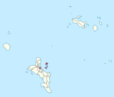
| Geographische Lage: |
Koordinaten: 4° 38′ S, 55° 27′ O |
| Insel: | Mahé (Seychellen) |
| Fläche: | 6,1 km²[1] |
| Einwohner: | 3607[2] |
| Bevölkerungsdichte: | 591 Einwohner/km² |
| Motto: | Surmount and Flourish |
| ISO 3166-2 code | SC-18 |

Mont Fleuri ist einer der 25 Verwaltungsbezirke der Seychellen. Der Distrikt bildet einen Teil der Hauptstadt Victoria und liegt südlich des Stadtzentrums. Mont Fleuri galt zu Kolonialzeiten als „Lower Middle Class“ Stadtteil. Heute befinden sich im Bezirk die großen Bildungseinrichtungen des Landes, darunter das Polytechnic College, Teachers Training College sowie die Französische und die Internationale Schule sowie andere Ausbildungsstätten. Weitere öffentliche Einrichtungen sind das Krankenhaus von Victoria und die Ministerien für Äußeres, Bildung und Umwelt. In Mont Fleuri siedelten entlang des Rochon River ab 1771 die ersten Siedler auf der Insel Mahé. Neben der Fläche auf der Hauptinsel Mahé, gehören die sechs im Sainte Anne Marine National Park liegenden Inseln vor dem Hafen von Victoria zum Bezirk, darunter Sainte Anne und Île au Cerf, auf denen sich Hotels befinden, sowie die Insel Moyenne, die sowohl Bestandteil der Ste Anne Marine Parks ist, wie auch den Status als eigenständigen Nationalpark besitzt. Eine Sehenswürdigkeit in Mont Fleuri ist der nach dem Bezirk benannte Botanische Garten.
Einzelnachweise
[Bearbeiten | Quelltext bearbeiten]- ↑ Website World Gazetteer: Seychellen: Verwaltungsgliederung (Bevölkerung und Fläche). ( des vom 29. Dezember 2011 im Internet Archive) Info: Der Archivlink wurde automatisch eingesetzt und noch nicht geprüft. Bitte prüfe Original- und Archivlink gemäß Anleitung und entferne dann diesen Hinweis. Abgefragt am 16. Dezember 2010.
- ↑ Government of the Seychelles: Statistical Bulletin, Population and Vital Statistics No. 2 of 2010. National Statistics Bureau, Victoria 2010. (PDF; 890 kB)
Anse aux Pins | Anse Boileau | Anse Etoile | Anse Royale | Au Cap | Baie Lazare | Baie Sainte Anne | Beau Vallon | Bel Air | Bel Ombre | Cascade | Glacis | Grand Anse (Mahé) | Grand Anse (Praslin) | La Digue and Inner Islands | La Rivière Anglaise | Les Mamelles | Mont Buxton | Mont Fleuri | Plaisance | Pointe La Rue | Port Glaud | Roche Caïman | Saint Louis | Takamaka
Kein Distrikt: Outer Islands
Text is available under the CC BY-SA 4.0 license; additional terms may apply.
Images, videos and audio are available under their respective licenses.
