Majerovce
aus Wikipedia, der freien Enzyklopädie
| Majerovce | |||
|---|---|---|---|
| Wappen | Karte | ||

|
| ||
| Basisdaten | |||
| Staat: | |||
| Kraj: | Prešovský kraj | ||
| Okres: | Vranov nad Topľou | ||
| Region: | Šariš | ||
| Fläche: | 3,54 km² | ||
| Einwohner: | 440 (31. Dez. 2022) | ||
| Bevölkerungsdichte: | 124 Einwohner je km² | ||
| Höhe: | 132 m n.m. | ||
| Postleitzahl: | 094 09 (Postamt Sedliská) | ||
| Telefonvorwahl: | 0 57 | ||
| Geographische Lage: | 48° 53′ N, 21° 43′ O | ||
| Kfz-Kennzeichen (vergeben bis 31.12.2022): |
VT | ||
| Kód obce: | 528838 | ||
| Struktur | |||
| Gemeindeart: | Gemeinde | ||
| Verwaltung (Stand: Oktober 2022) | |||
| Bürgermeister: | Ján Sarvaš | ||
| Adresse: | Obecný úrad Majerovce Sedliská 2 09409 Sedliská | ||
| Webpräsenz: | www.majerovce.eu | ||

Majerovce (bis 1927 „Majorovce“; ungarisch Majoros) ist eine kleine Gemeinde in der Ostslowakei.

Geografie
[Bearbeiten | Quelltext bearbeiten]Die Gemeinde Majerovce liegt nahe der Burgruine Čičava im Tal der Ondava, die hier aus dem Ondauer Bergland (Ondavská vrchovina) in das Ostslowakische Tiefland eintritt. Die Stadt Vranov nad Topľou ist nur vier Kilometer von Majerovce entfernt.
Geschichte
[Bearbeiten | Quelltext bearbeiten]Der Ort wurde im Jahr 1363 erstmals urkundlich erwähnt. Die römisch-katholische Kirche und die griechisch-katholische Kirche wurden erst in den 1990er Jahren erbaut.
-
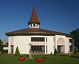 Römisch-katholische Kirche
 -
 Griechisch-katholische Kirche


Verkehrsanbindung
[Bearbeiten | Quelltext bearbeiten]Die Fernstraße 558 von Vranov nad Topľou nach Humenné führt durch die Gemeinde. Im nahen Vranov nad Topľou besteht Bahnanschluss (Bahnlinie Prešov–Michalovce).
Statistik
[Bearbeiten | Quelltext bearbeiten]Die Bevölkerung Majerovces besteht fast ausschließlich aus Slowaken. 80 % der Einwohner bekennen sich zur römisch-katholischen Kirche, 19 % gaben als Konfession griechisch-katholisch an.[1]
Einzelnachweise
[Bearbeiten | Quelltext bearbeiten]- ↑ (Seite nicht mehr abrufbar, festgestellt im April 2019. Suche in Webarchiven)
Weblinks
[Bearbeiten | Quelltext bearbeiten]Text is available under the CC BY-SA 4.0 license; additional terms may apply.
Images, videos and audio are available under their respective licenses.
