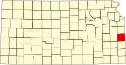
Linn County (Kansas)
aus Wikipedia, der freien Enzyklopädie
 Linn County Courthouse | |
| Verwaltung | |
|---|---|
| US-Bundesstaat: | Kansas |
| Verwaltungssitz: | Mound City |
| Adresse des Verwaltungssitzes: |
County Courthouse P.O. Box 350 Mound City, KS 66056-0350 |
| Gründung: | 26. Februar 1867 |
| Gebildet aus: | Indianerland |
| Vorwahl: | 001 913 |
| Demographie | |
| Einwohner: | 9.591 (Stand: 2020) |
| Bevölkerungsdichte: | 6,19 Einwohner/km2 |
| Geographie | |
| Fläche gesamt: | 1570 km² |
| Wasserfläche: | 20 km² |
| Karte | |
 | |
| Website: www.linncountyks.com | |
Das Linn County[1] ist ein County im US-Bundesstaat Kansas. Der Verwaltungssitz (County Seat) ist Mound City.[2] Das U.S. Census Bureau hat bei der Volkszählung 2020 eine Einwohnerzahl von 9591[3] ermittelt.
Das Linn County ist Bestandteil der Metropolregion Kansas City.
Geographie
[Bearbeiten | Quelltext bearbeiten]Das County liegt im Osten von Kansas, grenzt an Missouri und hat eine Fläche von 1570 Quadratkilometern, wovon 20 Quadratkilometer Wasserfläche sind. Es grenzt an folgende Countys:
| Franklin County | Miami County | |
| Anderson County | 
|
Bates County |
| Allen County | Bourbon County | Vernon County |
Geschichte
[Bearbeiten | Quelltext bearbeiten]
| Bevölkerungswachstum | |||
|---|---|---|---|
| Census | Einwohner | ± rel. | |
| 1860 | 6.336 | — | |
| 1870 | 12.174 | 92,1 % | |
| 1880 | 15.298 | 25,7 % | |
| 1890 | 17.215 | 12,5 % | |
| 1900 | 16.689 | −3,1 % | |
| 1910 | 14.735 | −11,7 % | |
| 1920 | 13.815 | −6,2 % | |
| 1930 | 13.534 | −2 % | |
| 1940 | 11.969 | −11,6 % | |
| 1950 | 10.053 | −16 % | |
| 1960 | 8.274 | −17,7 % | |
| 1970 | 7.770 | −6,1 % | |
| 1980 | 8.234 | 6 % | |
| 1990 | 8.254 | 0,2 % | |
| 2000 | 9.570 | 15,9 % | |
| 2010 | 9.656 | 0,9 % | |
| 2020 | 9.591 | −0,7 % | |
Vor 1900[4] 1900–1990[5] 2000 + 2010[6]
 | |||
Das Linn County wurde am 26. Februar 1867 aus als frei bezeichneten – in Wirklichkeit aber von Indianern besiedelten – Territorium gebildet. Benannt wurde es nach Lewis Fields Linn, einem US - Senator von Missouri.
Im Linn County liegt eine National Historic Landmark, die Marais des Cygnes Massacre Site.[7] Insgesamt sind 8 Bauwerke und Stätten des Countys im National Register of Historic Places eingetragen (Stand 30. August 2017).[8]
Demografische Daten
[Bearbeiten | Quelltext bearbeiten]Nach der Volkszählung im Jahr 2010 lebten im Linn County 9656 Menschen in 4022 Haushalten. Die Bevölkerungsdichte betrug 6,2 Einwohner pro Quadratkilometer.
Ethnisch betrachtet setzte sich die Bevölkerung zusammen aus 96,4 Prozent Weißen, 0,4 Prozent Afroamerikanern, 0,7 Prozent amerikanischen Ureinwohnern, 0,3 Prozent Asiaten sowie aus anderen ethnischen Gruppen; 1,5 Prozent stammten von zwei oder mehr Ethnien ab. Unabhängig von der ethnischen Zugehörigkeit waren 1,9 Prozent der Bevölkerung spanischer oder lateinamerikanischer Abstammung.
In den 4022 Haushalten lebten statistisch je 2,38 Personen.
23,2 Prozent der Bevölkerung waren unter 18 Jahre alt, 57,5 Prozent waren zwischen 18 und 64 und 19,3 Prozent waren 65 Jahre oder älter. 49,9 Prozent der Bevölkerung war weiblich.
Das jährliche Durchschnittseinkommen eines Haushalts lag bei 41.597 USD. Das Prokopfeinkommen betrug 21.731 USD. 12,8 Prozent der Einwohner lebten unterhalb der Armutsgrenze.[9]
Städte und Gemeinden
[Bearbeiten | Quelltext bearbeiten]
|
|
- Boicourt
- Cadmus
- Centerville
- Critzer
- Dunlay
- Farlinville
- Goodrich
- Mantey
- Trading Post
- Blue Mound Township
- Centerville Township
- Liberty Township
- Lincoln Township
- Mound City Township
- Paris Township
- Potosi Township
- Scott Township
- Sheridan Township
- Stanton Township
- Valley Township
Einzelnachweise
[Bearbeiten | Quelltext bearbeiten]- ↑ GNIS-ID: 485018. Abgerufen am 22. Februar 2011 (englisch).
- ↑ National Association of Counties, abgerufen am 24. Oktober 2011.
- ↑ US Census Bureau: Search Results Total Population in Linn County, Kansas. Abgerufen am 2. Februar 2024 (amerikanisches Englisch).
- ↑ U.S. Census Bureau - Census of Population and Housing, abgerufen am 15. März 2011.
- ↑ Auszug aus Census.gov, abgerufen am 17. Februar 2011.
- ↑ Auszug aus census.gov (2000+2010) ( des vom 14. Juli 2011 auf WebCite) Info: Der Archivlink wurde automatisch eingesetzt und noch nicht geprüft. Bitte prüfe Original- und Archivlink gemäß Anleitung und entferne dann diesen Hinweis., abgerufen am 2. April 2012.
- ↑ Listing of National Historic Landmarks by State: Kansas. National Park Service, abgerufen am 30. August 2017.
- ↑ Suchmaske Datenbank im National Register Information System. National Park Service, abgerufen am 30. August 2017.
- ↑ U.S. Census Buero, State & County QuickFacts - Linn County ( des vom 14. Juli 2011 auf WebCite) Info: Der Archivlink wurde automatisch eingesetzt und noch nicht geprüft. Bitte prüfe Original- und Archivlink gemäß Anleitung und entferne dann diesen Hinweis., abgerufen am 24. Oktober 2011.
Weblinks
[Bearbeiten | Quelltext bearbeiten]- U.S. Census Buero, State & County QuickFacts - Linn County
- Yahoo Bildersuche - Linn County
- www.city-data.com - Linn County
- Kansas Historical Society: Linn County. In: Kansapedia.
Koordinaten: 38° 6′ N, 95° 1′ W
Text is available under the CC BY-SA 4.0 license; additional terms may apply.
Images, videos and audio are available under their respective licenses.
