Lanciego
aus Wikipedia, der freien Enzyklopädie
| Gemeinde Lanciego/Lantziego | |||
|---|---|---|---|
 Lanciego/Lantziego (Herbstansicht) | |||
| Wappen | Karte von Spanien | ||

|
| ||
| Basisdaten | |||
| Land: | |||
| Autonome Gemeinschaft: | |||
| Provinz: | Álava | ||
| Comarca: | Rioja Alavesa | ||
| Gerichtsbezirk: | Vitoria-Gasteiz | ||
| Koordinaten: | 42° 34′ N, 2° 31′ W | ||
| Höhe: | 542 msnm | ||
| Fläche: | 24,20 km² | ||
| Einwohner: | 724 (1. Jan. 2022)[1] | ||
| Bevölkerungsdichte: | 30 Einw./km² | ||
| Postleitzahl(en): | 01308 | ||
| Gemeindenummer (INE): | 01032 | ||
| Verwaltung | |||
| Bürgermeister: | Itziar de Álava Martínez de Icaya (PNV) | ||
| Website: | Lanciego/Lantziego | ||
| Lage des Ortes | |||
Karte anzeigen  | |||

Lanciego (baskisch Lantziego; offiziell Lanciego/Lantziego) ist ein Ort und eine Gemeinde (municipio) mit 724 Einwohnern (Stand 1. Januar 2022) in der Provinz Álava in der Autonomen Gemeinschaft Baskenland im Norden Spaniens. Der Ort gehört zur Weinbauregion Rioja. Neben dem Hauptort Lanciego/Lantziego gehören auch die Ortschaft Viñaspre/Biasteri und die Wüstung Asa zur Gemeinde.
Lage
[Bearbeiten | Quelltext bearbeiten]Lanciego/Lantziego liegt in einer Höhe von etwa 540 Metern ü. d. M. im Osten der Provinz Álava an der Grenze zur Autonomen Gemeinschaft Navarra. Die Provinzhauptstadt Vitoria-Gasteiz liegt in etwa 40 Kilometer nordnordwestlicher Entfernung. Bei der Wüstung Asa bildet der Ebro einen Teil der südlichen Gemeindegrenze.
Bevölkerungsentwicklung
[Bearbeiten | Quelltext bearbeiten]| Jahr | 1960 | 1970 | 1981 | 1991 | 2001 | 2011 | 2021 |
| Einwohner | 858 | 699 | 575 | 641 | 654 | 682 | 692[2] |
Sehenswürdigkeiten
[Bearbeiten | Quelltext bearbeiten]- Im Gebiet der Wüstung Assa befindet sich die römische Brücke von Mantible aus dem zweiten nachchristlichen Jahrhundert
- Kirche des heiligen Ascylus und der heiligen Viktoria (Iglesia de San Acisclo y Santa Victoria)
- Marienkapelle (Ermita de Santa María del Campo)
-
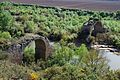 Römische Brücke von Mantible
 -
 Kirche des heiligen Ascylus und der heiligen Viktoria

.jpg)
Weblinks
[Bearbeiten | Quelltext bearbeiten]Einzelnachweise
[Bearbeiten | Quelltext bearbeiten]- ↑ Cifras oficiales de población de los municipios españoles en aplicación de la Ley de Bases del Régimen Local (Art. 17). Instituto Nacional de Estadística (Bevölkerungsstatistiken des Instituto Nacional de Estadística, Stand 1. Januar 2022).
- ↑ Lanciego/Lantziego - Bevölkerungstabellen
Alegría-Dulantzi | Amurrio | Añana | Aramaio | Armiñón | Arraia-Maeztu | Arratzua-Ubarrundia | Artziniega | Asparrena | Ayala/Aiara | Baños de Ebro/Mañueta | Barrundia | Berantevilla | Bernedo | Campezo/Kanpezu | Elburgo/Burgelu | Elciego | Elvillar/Bilar | Erriberagoitia/Ribera Alta | Harana/Valle de Arana | Iruña Oka/Iruña de Oca | Iruraiz-Gauna | Kripan | Kuartango | Labastida/Bastida | Lagrán | Laguardia | Lanciego/Lantziego | Lantarón | Lapuebla de Labarca | Laudio/Llodio | Legutio | Leza | Moreda de Álava/Moreda Araba | Navaridas | Okondo | Oyón-Oion | Peñacerrada-Urizaharra | Ribera Baja/Erriberabeitia | Salvatierra/Agurain | Samaniego | San Millán/Donemiliaga | Urkabustaiz | Valdegovía/Gaubea | Villabuena de Álava/Eskuernaga | Vitoria-Gasteiz | Yécora/Iekora | Zalduondo | Zambrana | Zigoitia | Zuia
Text is available under the CC BY-SA 4.0 license; additional terms may apply.
Images, videos and audio are available under their respective licenses.
