Kreis Komárom
aus Wikipedia, der freien Enzyklopädie
| Kreis Komáromi járás
Komárom | |
|---|---|
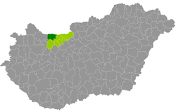
 Lage des Kreises in Ungarn | |
| Basisdaten | |
| Staat | Ungarn |
| Komitat | Komárom-Esztergom |
| Sitz | Komárom |
| Fläche | 378,5 km² |
| Einwohner | 38.970 (1. Januar 2016) |
| Dichte | 103 Einwohner pro km² |
Der Kreis Komárom (ungarisch Komáromi járás) ist ein Kreis im nordungarischen Komitat Komárom-Esztergom. Er grenzt im Westen an den Kreis Tata und im Südwesten an den Kreis Tatabánya. Im Norden bildet die Donau die Staatsgrenze zur Slowakei, 3 Grenzgemeinden liegen an dem Fluss.
Geschichte
[Bearbeiten | Quelltext bearbeiten]Der Kreis ging während der ungarischen Verwaltungsreform Anfang 2013 als Nachfolger des gleichnamigen Kleingebiets (ungarisch Komáromi kistérség) in unveränderter Gemeindezuordnung hervor (9 Gemeinden).
Gemeindeübersicht
[Bearbeiten | Quelltext bearbeiten]Der Kreis Komárom hat eine durchschnittliche Gemeindegröße von 4.330 Einwohnern auf einer Fläche von 42,06 Quadratkilometern. Die Bevölkerungsdichte liegt unter der für das gesamte Komitat. Der Verwaltungssitz befindet sich in der größten Stadt, Komárom, im Norden des Kreises gelegen.
| Gemeinde | Status | Herkunft Kleingebiet |
Einwohnerzahl | Fläche (km²) | Bevölkerungs- dichte (Ew./km²) | ||
|---|---|---|---|---|---|---|---|
| 01.10.2011 | 01.01.2013 | 01.01.2016 | |||||
| Ács * | Stadt | Komárom | 6.875 | 6.808 | 6.793 | 103,83 | 65,4 |
| Almásfüzitő * | Gemeinde | Komárom | 2.144 | 2.089 | 2.090 | 8,19 | 255,2 |
| Bábolna | Stadt | Komárom | 3.808 | 3.774 | 3.840 | 33,55 | 114,5 |
| Bana | Gemeinde | Komárom | 1.649 | 1.630 | 1.633 | 25,11 | 65,0 |
| Csém | Gemeinde | Komárom | 421 | 416 | 393 | 6,28 | 62,6 |
| Kisigmánd | Gemeinde | Komárom | 518 | 475 | 462 | 13,13 | 35,2 |
| Komárom * | Stadt | Komárom | 19.284 | 19.200 | 18.786 | 69,90 | 268,8 |
| Mocsa | Gemeinde | Komárom | 2.192 | 2.142 | 2.095 | 67,20 | 31,2 |
| Nagyigmánd | Großgemeinde | Komárom | 2.972 | 3.025 | 2.878 | 51,35 | 56,0 |
| Kreis Komárom | 39.863 | 39.559 | 38.970 | 378,54 | 102,9 | ||
* Grenzorte zur Slowakei
Quellen
[Bearbeiten | Quelltext bearbeiten]PDF- und XLS-Dateien:
Volkszählung 2011: [1][2]
2013: [3];
2016: [4]
Einzelnachweise
[Bearbeiten | Quelltext bearbeiten]- ↑ KSH: 2011. Évi Népszámlálás. In: 3. Területi adatok. KSH, abgerufen am 26. Dezember 2016 (ungarisch, auch über: https://terezvaros.hu/testuleti/nepsz2011-3/pdf/nepsz2011_03_11.pdf).
- ↑ KSH: Regional data – Komárom-Esztergom county. KSH, abgerufen am 26. Dezember 2016 (englisch, 4. Data on Localities).
- ↑ KSH: Gazetteer of Hungary, 1st January, 2013. KSH, abgerufen am 25. März 2017 (ungarisch/englisch).
- ↑ KSH: Gazetteer of Hungary, 1st January, 2016. KSH, abgerufen am 25. März 2017 (ungarisch/englisch).
Text is available under the CC BY-SA 4.0 license; additional terms may apply.
Images, videos and audio are available under their respective licenses.
