Huntingdonshire
aus Wikipedia, der freien Enzyklopädie
| Huntingdonshire District | |
|---|---|
 Lage in Cambridgeshire | |
| Status | District |
| Region | East of England |
| Verw.grafschaft | Cambridgeshire |
| Verwaltungssitz | Huntingdon |
| Fläche | 912,47 km² (34.) |
| Einwohner | 167.700 (92.) |
| ONS-Code | 12UE |
| Website | www.huntsdc.gov.uk |
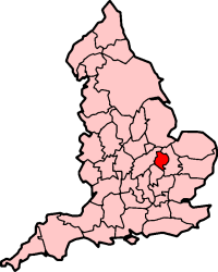
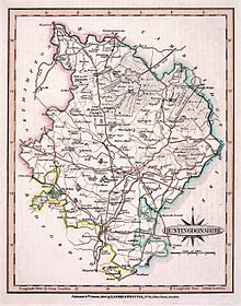
Huntingdonshire (abgekürzt Hunts) war eine der 39 traditionellen Grafschaften Englands; heute ist Huntingdonshire ein Distrikt der Grafschaft Cambridgeshire.
Geschichte
[Bearbeiten | Quelltext bearbeiten]Die Grafschaft Huntingdonshire war die drittkleinste Grafschaft Englands und wurde 1965 mit dem Soke of Peterborough zur neuen Grafschaft Huntingdon and Peterborough vereinigt. 1974 wurde Huntingdonshire der Grafschaft Cambridgeshire zugeordnet, zunächst als Distrikt Huntingdon; seit 1984 trägt der Distrikt seinen heutigen Namen.
Huntingdonshire wird noch heute von vielen als Grafschaft angesehen. Obwohl bei der Kommunalreform in den 1990er Jahren die Grafschaften Rutland und Herefordshire wiederhergestellt wurden, blieb es beim jetzigen Status von Huntingdonshire.
Der heutige Distrikt stimmt nicht genau mit den traditionellen Grenzen der Grafschaft überein. Der Ort Fletton gehört heute zu City of Peterborough, Everton zu Bedfordshire; auch Swineshead wird von dort verwaltet. Dafür erhielt Huntingdonshire Eaton Ford und Eaton Socon von Bedfordshire. Der Verwaltungssitz befindet sich in Huntingdon.
Städte und Orte
[Bearbeiten | Quelltext bearbeiten]

Städte
[Bearbeiten | Quelltext bearbeiten]- Huntingdon
- Ramsey
- St Ives
- St Neots
Andere Orte
[Bearbeiten | Quelltext bearbeiten]- Alconbury, Alconbury Weston
- Bury, Bluntisham, Brampton, Buckden
- Catworth, Cofford D’Arcy, Colne, Covington
- Earith, Ellington, Elton, Everton
- Fletton, Fenstanton
- Glatton, Great Gransden, Great Paxton, Great Stukeley, Great Staughton
- Hilton, Holme
- Keystone, Kimbolton, Kings Ripton
- Leighton Bromswold, Little Paxton, Little Stukeley
- Molesworth
- Offord Cluny, Old Weston, Orton Longville
- Sawtry, Somersham, Stilton, Stanground, Swineshead
- Upthorn, Upwood
- Warboys, Water Newton, Woolley
- Yelling
Weblinks
[Bearbeiten | Quelltext bearbeiten]- Huntingdonshire District Council (englisch)
- Huntingdonshire (englisch)
- The Huntingdonshire Society (englisch)
- Literatur von und über Huntingdonshire im Katalog der Deutschen Nationalbibliothek
Koordinaten: 52° 25′ N, 0° 15′ W
Text is available under the CC BY-SA 4.0 license; additional terms may apply.
Images, videos and audio are available under their respective licenses.
