Fuentesaúco de Fuentidueña
aus Wikipedia, der freien Enzyklopädie
| Gemeinde Fuentesaúco de Fuentidueña | |||
|---|---|---|---|
| Wappen | Karte von Spanien | ||

|
| ||
| Basisdaten | |||
| Land: | |||
| Autonome Gemeinschaft: | |||
| Provinz: | Segovia | ||
| Comarca: | Sepúlveda | ||
| Gerichtsbezirk: | Cuéllar | ||
| Koordinaten: | 41° 25′ N, 4° 4′ W | ||
| Höhe: | 892 msnm | ||
| Fläche: | 25,85 km² | ||
| Einwohner: | 237 (1. Jan. 2022)[1] | ||
| Bevölkerungsdichte: | 9 Einw./km² | ||
| Postleitzahl(en): | 40355 | ||
| Gemeindenummer (INE): | 40089 | ||
| Verwaltung | |||
| Bürgermeister: | Javier Polo García (PP) | ||
| Website: | Fuentesaúco de Fuentidueña | ||
| Lage des Ortes | |||
Karte anzeigen  | |||

Fuentesaúco de Fuentidueña ist ein Ort und eine nordspanische Gemeinde (municipio) mit insgesamt 237 Einwohnern (Stand 1. Januar 2022) in der Provinz Segovia in der Autonomen Gemeinschaft Kastilien-León.
Lage und Klima
[Bearbeiten | Quelltext bearbeiten]Die Gemeinde Fuentesaúco de Fuentidueña liegt etwa 55 km (Fahrtstrecke) nördlich von Segovia in einer mittleren Höhe von ca. 890 m. Das Klima ist im Winter rau, im Sommer dagegen gemäßigt bis warm; Regen (ca. 499 mm/Jahr) fällt übers Jahr verteilt.[2]
Bevölkerungsentwicklung
[Bearbeiten | Quelltext bearbeiten]| Jahr | 1970 | 1981 | 1991 | 2001 | 2011 | 2021 |
| Einwohner | 918 | 788 | 406 | 307 | 274 | 234[3] |
Sehenswürdigkeiten
[Bearbeiten | Quelltext bearbeiten]- Dominikuskirche
-
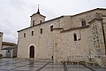 Dominikuskirche

Weblinks
[Bearbeiten | Quelltext bearbeiten]Einzelnachweise
[Bearbeiten | Quelltext bearbeiten]- ↑ Cifras oficiales de población de los municipios españoles en aplicación de la Ley de Bases del Régimen Local (Art. 17). Instituto Nacional de Estadística (Bevölkerungsstatistiken des Instituto Nacional de Estadística, Stand 1. Januar 2022).
- ↑ Fuentesaúco de Fuentidueña – Klimatabellen
- ↑ Fuentesaúco de Fuentidueña – Bevölkerungsentwicklung
Abades | Adrada de Pirón | Adrados | Aguilafuente | Alconada de Maderuelo | Aldea Real | Aldealcorvo | Aldealengua de Pedraza | Aldealengua de Santa María | Aldeanueva de la Serrezuela | Aldeanueva del Codonal | Aldeasoña | Aldehorno | Aldehuela del Codonal | Aldeonte | Anaya | Añe | Arahuetes | Arcones | Arevalillo de Cega | Armuña | Ayllón | Barbolla | Basardilla | Bercial | Bercimuel | Bernardos | Bernuy de Porreros | Boceguillas | Brieva | Caballar | Cabañas de Polendos | Cabezuela | Calabazas de Fuentidueña | Campo de San Pedro | Cantalejo | Cantimpalos | Carabias | Carbonero el Mayor | Carrascal del Río | Casla | Castillejo de Mesleón | Castro de Fuentidueña | Castrojimeno | Castroserna de Abajo | Castroserracín | Cedillo de la Torre | Cerezo de Abajo | Cerezo de Arriba | Chañe | Cilleruelo de San Mamés | Cobos de Fuentidueña | Coca | Codorniz | Collado Hermoso | Condado de Castilnovo | Corral de Ayllón | Cozuelos de Fuentidueña | Cubillo | Cuéllar | Cuevas de Provanco | Domingo García | Donhierro | Duruelo | Encinas | Encinillas | Escalona del Prado | Escarabajosa de Cabezas | Escobar de Polendos | El Espinar | Espirdo | Fresneda de Cuéllar | Fresno de Cantespino | Fresno de la Fuente | Frumales | Fuente de Santa Cruz | Fuente el Olmo de Fuentidueña | Fuente el Olmo de Íscar | Fuentepelayo | Fuentepiñel | Fuenterrebollo | Fuentesaúco de Fuentidueña | Fuentesoto | Fuentidueña | Gallegos | Garcillán | Gomezserracín | Grajera | Honrubia de la Cuesta | Hontalbilla | Hontanares de Eresma | Los Huertos | Ituero y Lama | Juarros de Riomoros | Juarros de Voltoya | Labajos | Laguna de Contreras | Languilla | Lastras de Cuéllar | Lastras del Pozo | La Lastrilla | La Losa | Maderuelo | Marazoleja | Marazuela | Martín Miguel | Martín Muñoz de la Dehesa | Martín Muñoz de las Posadas | Marugán | Mata de Cuéllar | Matabuena | La Matilla | Melque de Cercos | Membibre de la Hoz | Migueláñez | Montejo de Arévalo | Montejo de la Vega de la Serrezuela | Monterrubio | Moral de Hornuez | Mozoncillo | Muñopedro | Muñoveros | Nava de la Asunción | Navafría | Navalilla | Navalmanzano | Navares de Ayuso | Navares de Enmedio | Navares de las Cuevas | Navas de Oro | Navas de Riofrío | Navas de San Antonio | Nieva | Olombrada | Orejana | Ortigosa de Pestaño | Ortigosa del Monte | Otero de Herreros | Pajarejos | Palazuelos de Eresma | Pedraza | Pelayos del Arroyo | Perosillo | Pinarejos | Pinarnegrillo | Prádena | Puebla de Pedraza | Rapariegos | Rebollo | Remondo | Riaguas de San Bartolomé | Riaza | Ribota | Riofrío de Riaza | Roda de Eresma | Sacramenia | Samboal | San Cristóbal de Cuéllar | San Cristóbal de la Vega | San Cristóbal de Segovia | Real Sitio de San Ildefonso | San Martín y Mudrián | San Miguel de Bernuy | San Pedro de Gaíllos | Sanchonuño | Sangarcía | Santa María la Real de Nieva | Santa Marta del Cerro | Santiuste de Pedraza | Santiuste de San Juan Bautista | Santo Domingo de Pirón | Santo Tomé del Puerto | Sauquillo de Cabezas | Sebúlcor | Segovia | Sepúlveda | Sequera de Fresno | Sotillo | Sotosalbos | Tabanera la Luenga | Tolocirio | Torre Val de San Pedro | Torreadrada | Torrecaballeros | Torrecilla del Pinar | Torreiglesias | Trescasas | Turégano | Urueñas | Valdeprados | Valdevacas de Montejo | Valdevacas y Guijar | Valle de Tabladillo | Vallelado | Valleruela de Pedraza | Valleruela de Sepúlveda | Valseca | Valtiendas | Valverde del Majano | Veganzones | Vegas de Matute | Ventosilla y Tejadilla | Villacastín | Villaverde de Íscar | Villaverde de Montejo | Villeguillo | Yanguas de Eresma | Zarzuela del Monte | Zarzuela del Pinar
Text is available under the CC BY-SA 4.0 license; additional terms may apply.
Images, videos and audio are available under their respective licenses.
